
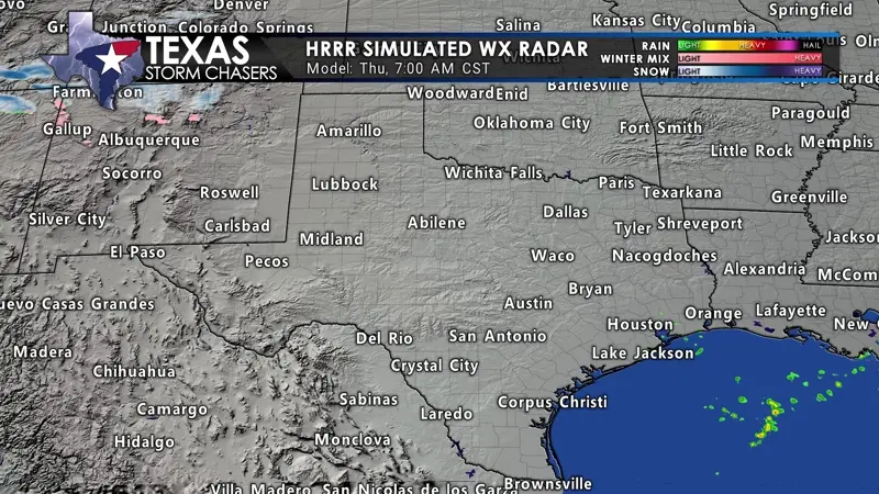
Simulated weather model radar this evening through Friday morning.
TSC Mobile App Users will need to click the black image/? Boxes to view animations.
A line of strong to severe thunderstorms are possible late tonight into Friday’s pre-dawn hours in North Texas, Northeast Texas, the Ark-La-Tex, and East Texas. The primary timeframe is 10 PM through 5 AM, though it may be closer to midnight to 5 AM. A strong cold front will move east across Texas today, tonight, and Friday. Gusty southeast winds ahead of the front will give way to strong westerly winds. Wind gusts may exceed 50 MPH, just like a few nights ago. As that cold front approaches Interstate 35 tonight, scattered to a nearly solid line of thunderstorms will erupt from the Red River south into Central Texas. Those storms will quickly march east early Friday morning. Storms will exit Texas into Louisiana by sunrise Friday.
Severe Thunderstorm Outlook
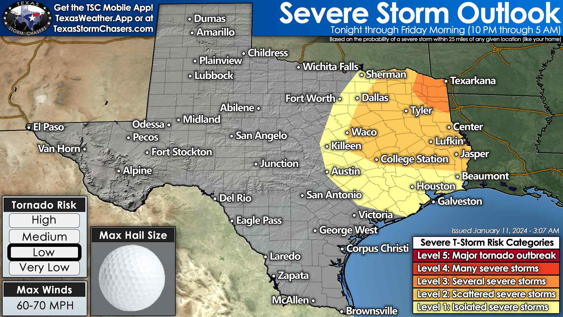
Strong wind shear and a modestly unstable environment will support organized thunderstorms. Damaging straight-line winds, large hail, and spinup tornadoes are possible. The tornado threat will increase if any storms develop ahead of the squall line in Northeast Texas and the Ark-La-Tex. If we see any storms in the squall line try to go rogue, the tornado threat will increase. Tonight’s threat will be completely nocturnal and occur during the early morning hours of Friday. Rain chances and the severe thunderstorm threat will end by sunrise in Texas.
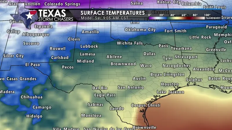
Before we have storms tonight in the eastern third of Texas, we may have snow in the Panhandle and West Texas. As a strong cold front moves southeast, snow showers may fire up in the aforementioned regions. A dusting to perhaps one inch of blowing snow may fall. We don’t anticipate a significant winter storm, but with frigid temperatures, snow could stick. Strong winds will kick it up and blow it around, too. Snow will move out of the region late tonight.
Brutal Cold Temperatures Arrive This Weekend
A arctic cold front will blast south across Texas on Saturday into Sunday morning. Strong north winds and a drastic drop in temperatures will occur behind the front.
It’ll be cooler across Texas on Friday and Saturday. Our much-anticipated arctic cold front begins crashing south into Texas on Saturday. Not surprisingly, the timing of its arrival has sped up. The cold front should make it through most of Texas by Sunday morning. Temperatures will drop thirty to forty degrees with strong north winds. A brutally cold airmass will spread across the northern half to the northern two-thirds of Texas on Sunday and Monday. A statewide freeze is expected on Sunday night and Monday night. Temperatures will fall below zero in the Texas Panhandle, with temperatures dangerously close to zero across West Texas, Northwest Texas, Texoma, North Texas, and Northeast Texas both nights. The northern half of Texas will remain below freezing from Sunday through Tuesday afternoon.
-
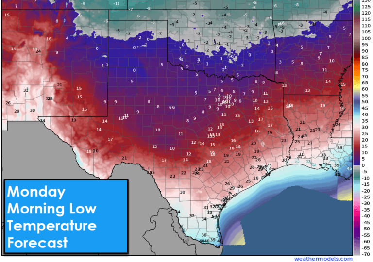
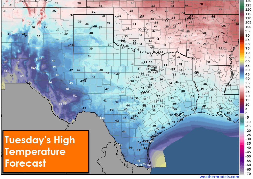
- Monday Morning Low Temperatures

-
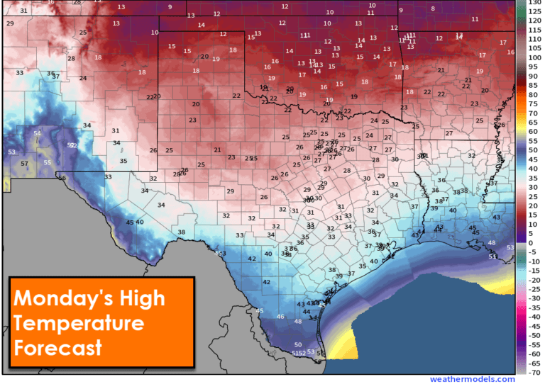
- Monday Afternoon High Temperatures
-
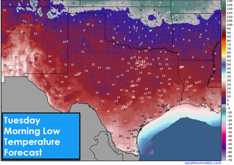
- Tuesday Morning Low Temperatures

-
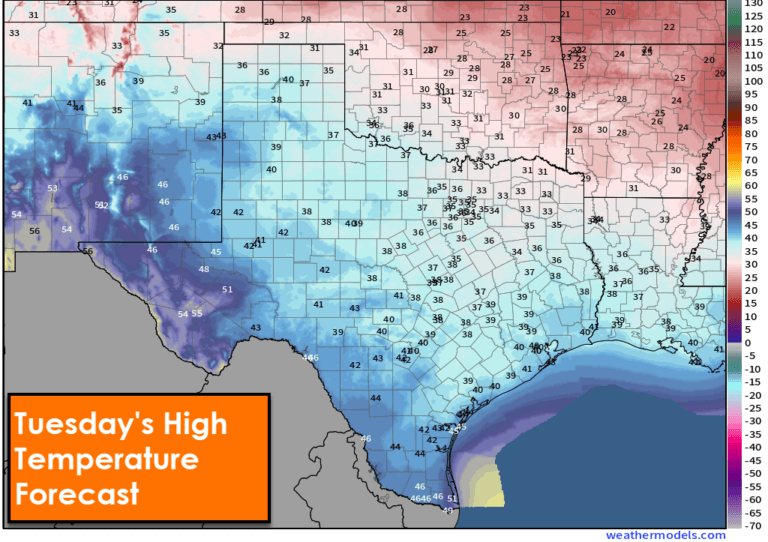
- Tuesday Afternoon High Temperatures
-
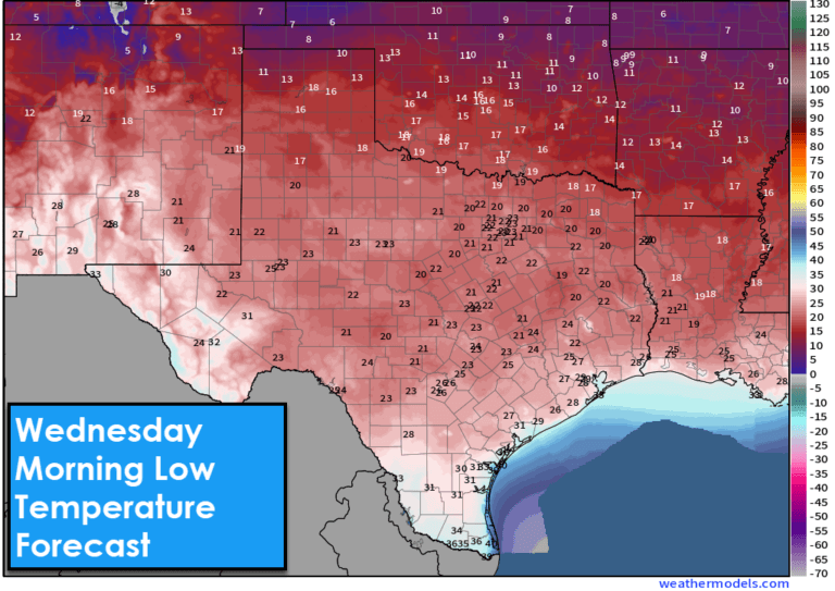
- Wednesday Morning Low Temperatures

-
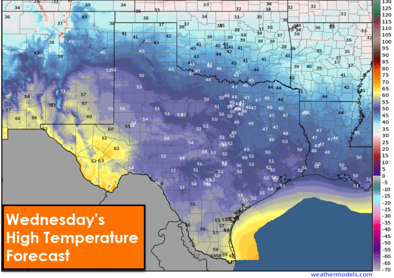
- Wednesday Afternoon High Temperatures

Northeast Texas may stay below freezing from Sunday through Wednesday afternoon. Wind chill temperatures will average ten to twenty degrees below the actual air temperature. Considering low temperatures will be below zero to the single digits above zero, wind chills may be twenty below at times. Low temperatures will fall into the teens as far south as San Antonio and Houston on Tuesday morning. Most of Texas will climb above freezing for several hours Tuesday afternoon before falling under Tuesday night. A more pronounced warmup will bring the 40s, 50s, and even 60s to Texas Wednesday afternoon – ending our arctic intrusion… until another wave tries to pounce in about a week.
Winter mischief Sunday Night and Monday?
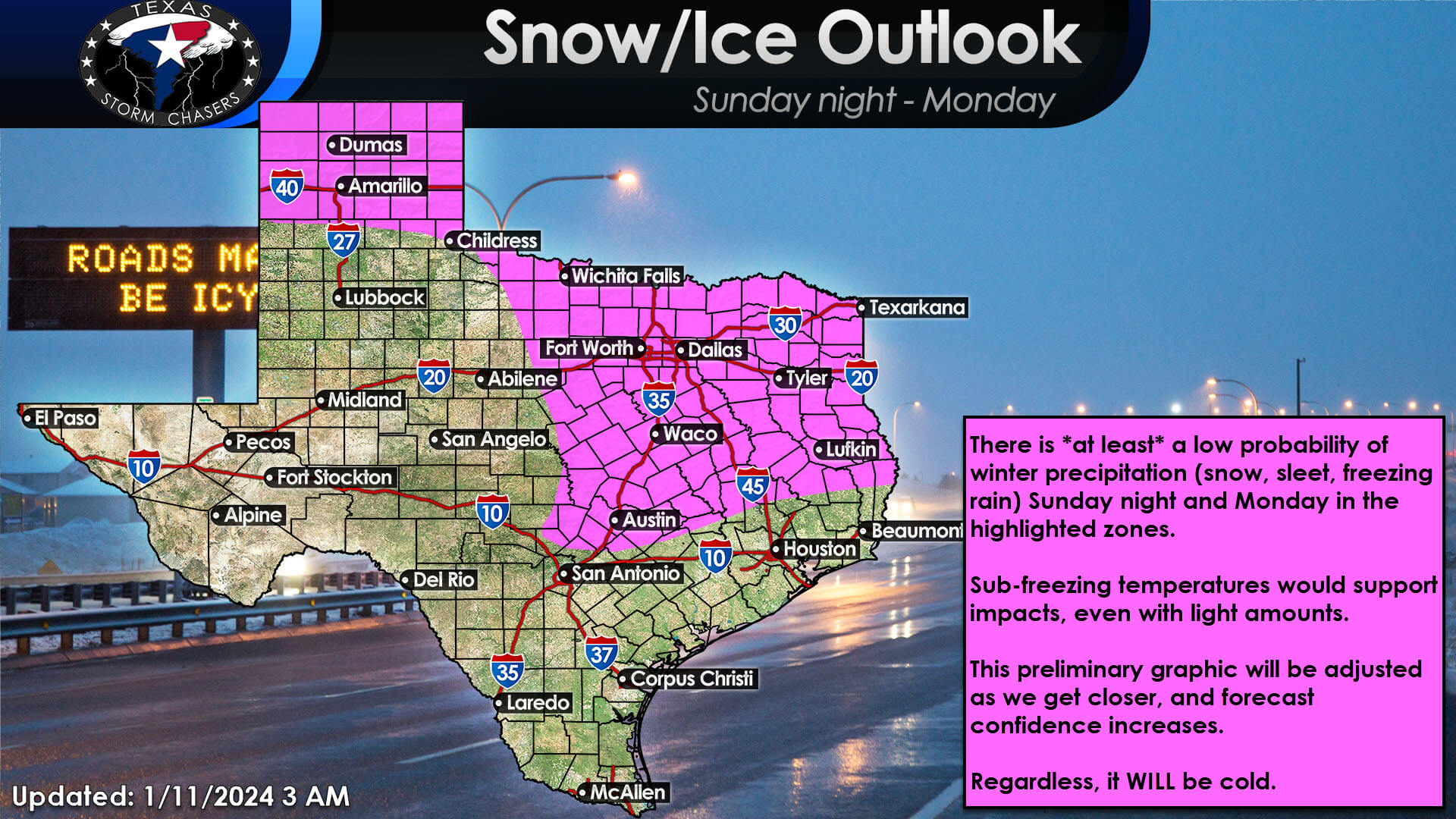
There is at least a low probability of winter precipitation (snow, sleet, freezing rain) Sunday night and on Monday from the Texas Panhandle southeast through Texoma, North Texas, Central Texas, the Hill Country, the Brazos Valley, East Texas, Northeast Texas, and the Ark-La-Tex. Confidence in the very cold air is high. Confidence in the timing, location, and extent of any winter mischief outside of hte cold is much lower. Any winter precipitation that does fall, even light, will be problematic given the cold temperatures. As we get closer to Monday, we’ll be able to get more specific and narrow down potential impacts, if any.
Video
Get the FREE Texas Storm Chasers Mobile App for your local weather forecast, interactive weather radars, live Texas weather coverage, and more! Available in your device’s app store.
Best weather reporter out there!! ✅
This looks very suspect