
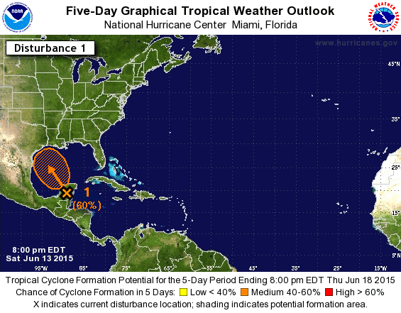
Chance of becoming a tropical depression or weak tropical storm is now at 60% before the system arrives in Texas.
A broad area of low pressure located over the Yucatan Peninsula this evening. This low will move north/northwest into the southwest Gulf of Mexico on Sunday. Weather model guidance is in general agreement of a northwest track towards the Texas coast. Until the broad low pressure tightens up I can’t accurately tell you where it will make landfall or at what time. There remains a 12-18 hour difference between two sets of weather model ‘camps’ but the storm system should arrive sometime on Tuesday. Regardless of the system becoming a tropical depression, tropical storm, or simply a broad low pressure, it will bring increasing moisture and rain chances to Southeast and East Texas on Tuesday and Wednesday. The southeast winds with the storm system will push copious amounts of moisture inland allowing for efficient and very heavy rainfall production. Typically we will see the heaviest rains along and east of the low pressure area but we’ll continue to refine that aspect of the forecast.
Are we expecting a hurricane with this system?
I’m very confident in saying this system will not become a hurricane. Weather models say this system could become a tropical depression or weak tropical storm. A tropical storm has winds over 38 MPH and I don’t expect we’ll see a storm much stronger then that at this time.
Will this be like May for all of Texas?
The heavy/widespread rains will be along and east of the storm. That puts Northeast Texas, East Texas, and Southeast Texas in the favored zone for potential flooding. While popup storms and rain will be possible in other parts of Texas that will be from typical summer thunderstorms.
What about storm surge or high winds?
Based on the current expectations of this system if it is able to become a tropical depression or weak tropical storm the overall storm surge impacts would be minimal. Only a small portion of the storm system itself would contain the 35+ MPH winds. Lets be honest – we see those kind of winds in a typical afternoon thunderstorm. One possible threat will be brief spin up tornadoes in the eastern quadrant of the low pressure though since wind shear will be enhanced.
Rain Forecast and Totals

Rain forecast through Thursday
The Weather Prediction Center has indicated widespread rain totals of 2 to 4 inches will be possible across Northeast Texas and East Texas. 3 to 5 inches of rain will be possible in Southeast Texas. Isolated rain totals of 5 to 8 inches could occur in localized areas. The heaviest rains will fall along and east of the storm’s track. If the forecast shifts the storm west more of Texas will have a rain threat. Widespread flooding is not in the forecast at this time. Since most of the region has dried out over the past two weeks soils are once again able to take some rain. Localized flooding will certainly be possible but we’ll continue to refine that aspect of the forecast.
Latest Forecast Track
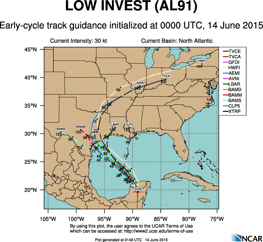
June 13, 2015 7 PM CDT Model Runs of potential track of system SHOULD IT DEVELOP.
* WEATHER MODEL DATA – NOT AN OFFICIAL FORECAST *
Once we get a focused area of low pressure we’ll be able to start pinning down the storm’s track more accurately. Honestly it doesn’t matter too much because we’ll be talking about a relatively disorganized system – not a tightened up hurricane. The eventual track of the storm both in the Gulf of Mexico and in Texas is dependent on another storm system located in the northern plains of the United States since the jetstream would pick up the storm and get it out of Texas. The slower the storm system moves the more rain some locations will pick up. We should have a better idea of many things come Sunday.
The Hurricane Hunters are scheduled to fly out tomorrow and investigate this system if it is necessary.


0 Comments