
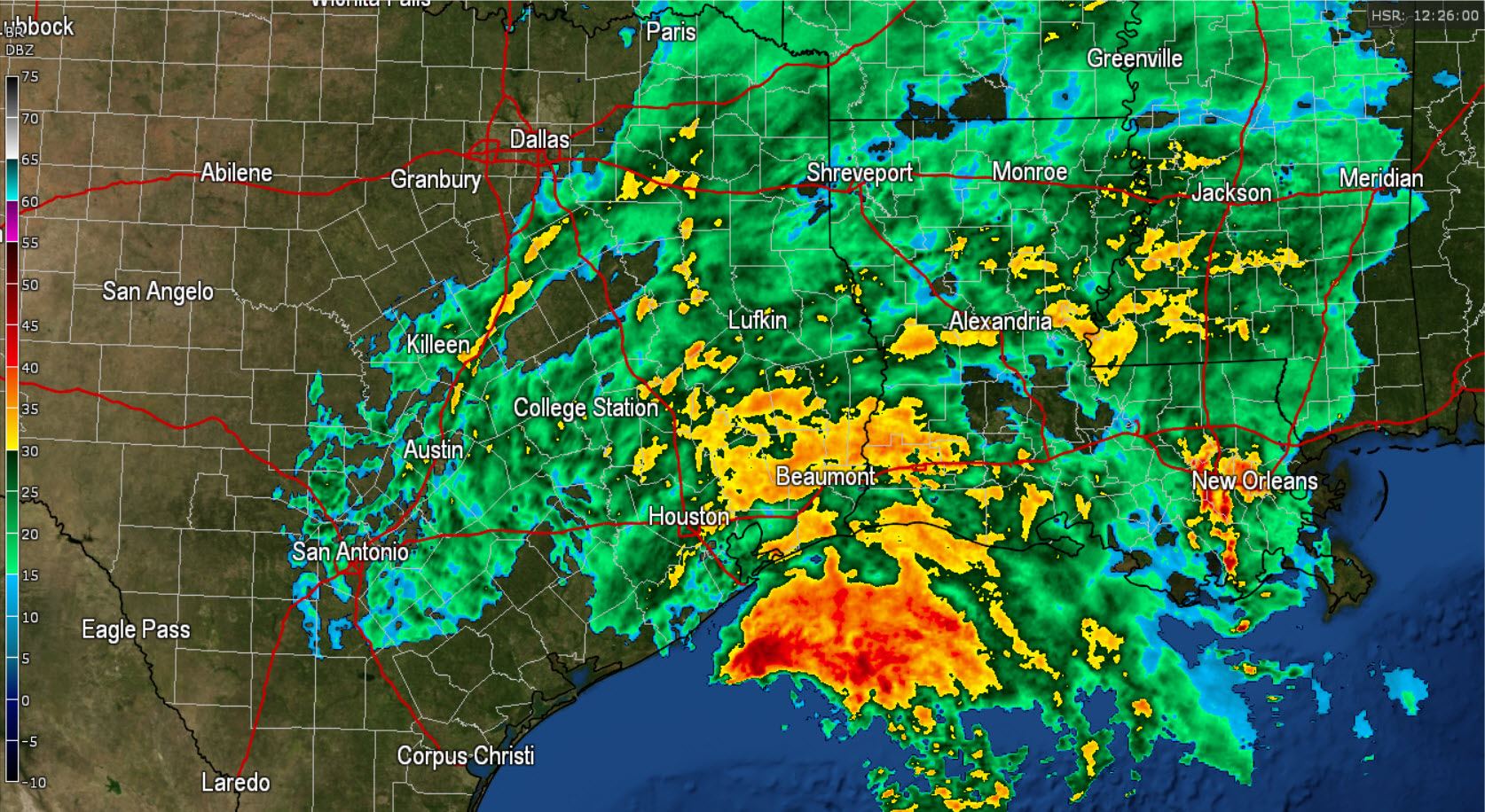
Good Sunday Morning! Northeast Texas, East Texas, Southeast Texas, and parts of Central Texas are waking up to a wet morning. There are pockets of locally heavy rain across Southeast Texas generally from Livingston to Liberty and Beaumont. The extremely heavy rain is offshore and we should be thankful for that.
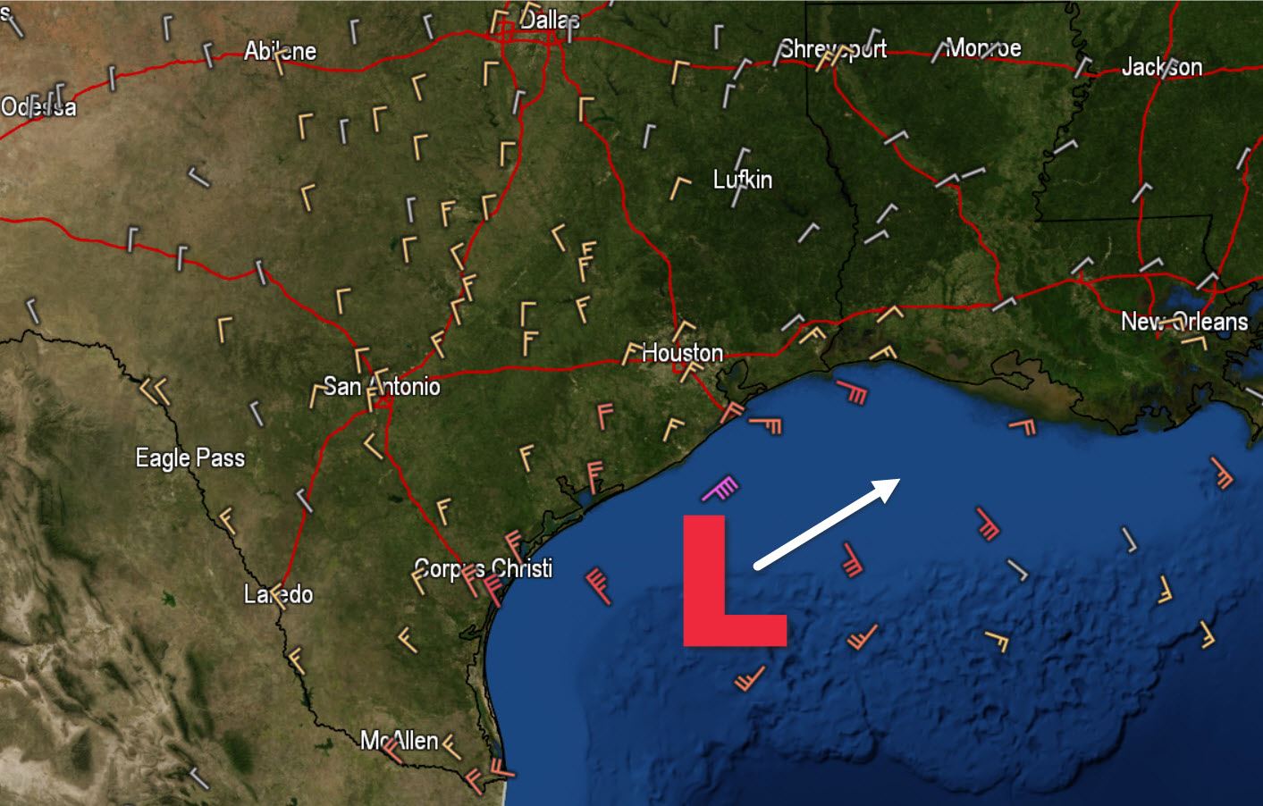
The ongoing rain is being caused by an area of low pressure located about 60 miles south of Galveston. This low is not tropical in nature but is producing sustained winds near tropical storm force off-shore. Several buoy and rig readings have wind gusts in the 50-55 MPH range. As the day proceeds the low pressure will move northeast and eventually move onshore in southern Louisiana later tonight. With the eastward progression we’ll see the rain also start ending from west to east throughout the day.
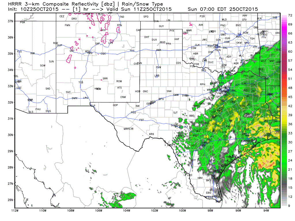
The 5 AM run of the High Resolution Rapid Refresh (HRRR) weather model shows the rain’s progression from west to end pretty well. As we continue through the day rain rain will move out of Central Texas by mid-afternoon. By dinner-time light rain is still possible across East Texas and extreme Southeast Texas. All that rain will continue to move east overnight. As ongoing rain totals are fairly light we’re not expecting much in the way of additional flash flooding. There remain a couple troublespots from the heavy rain over the past few days. In addition we’ll be dealing with river flooding for most of this week as water moves downstream across Texas rivers.

With clear skies and a much cooler airmass in place across the Texas Panhandle and West Texas we’ve seen temperatures drop off overnight. Most locations are in the 30s this morning with a couple just above freezing. A repeat is anticipated tonight with the 30s becoming more widespread.
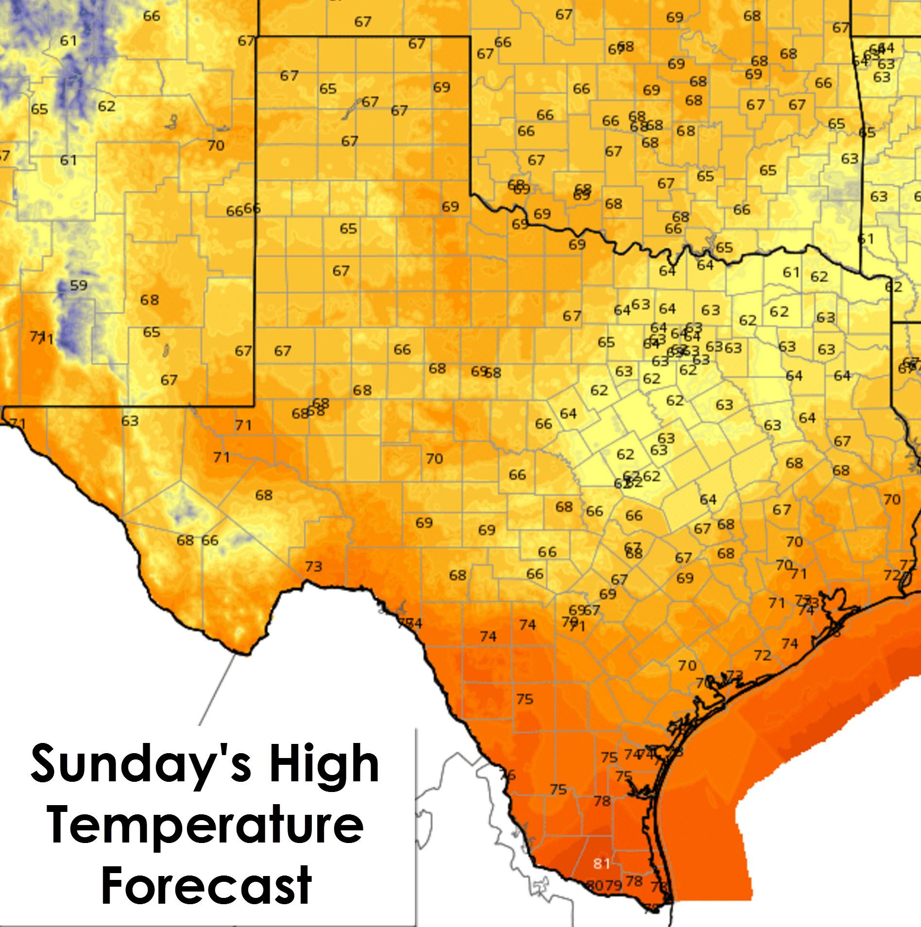
High temperatures today are going to be right around or a few degrees below seasonal averages for late October. Outside of the Rio Grande Valley and immediate cost most locations will top out in the upper 60s to right around 70 degrees today. Northeast Texas and parts of North Texas may be a few degrees cooler with highs only in the mid 60s this afternoon. Compare that to high temperatures in the upper 80s to mid 90s about a week ago. The Rio Grande Valley will be in the upper 70s this afternoon where the gulf moisture is never too far away.
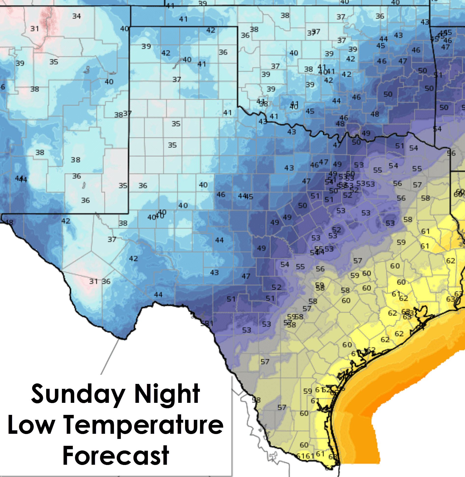
For tonight the low temperature forecast map is looking mighty blue. That’s because low temperatures across the Texas Panhandle, South Plains, Permian Basin, and Northwest Texas are forecast to drop into the mid 30s to low 40s. One or two of the colder spots may briefly hit freezing along with more widespread frost. North Texas and the hill Country will top out in the upper 40s to low 50s. Northeast Texas, East Texas, Central Texas, and South-Central Texas will enjoy a cool night with upper 50s to low 60s. Even Southeast Texas, Deep South Texas, and the Rio Grande Valley are going to get in on the cooler air as low temperatures tonight drop into the upper 50s to low 60s.

We’ll enjoy a few days of dry weather before another upper level low begins to approach in the Thursday timeframe. Rain chances look to go right back up for parts of Texas by Thursday, Friday, and even Saturday. At this point there is no accurate way to say who will still be getting rain during the Saturday evening festivities. Current weather model guidance does indicate some locations may receive 3+ inches of rain. Additional flooding is a possibility with this system so we’ll watch it closely as we continue into the work week.


0 Comments