
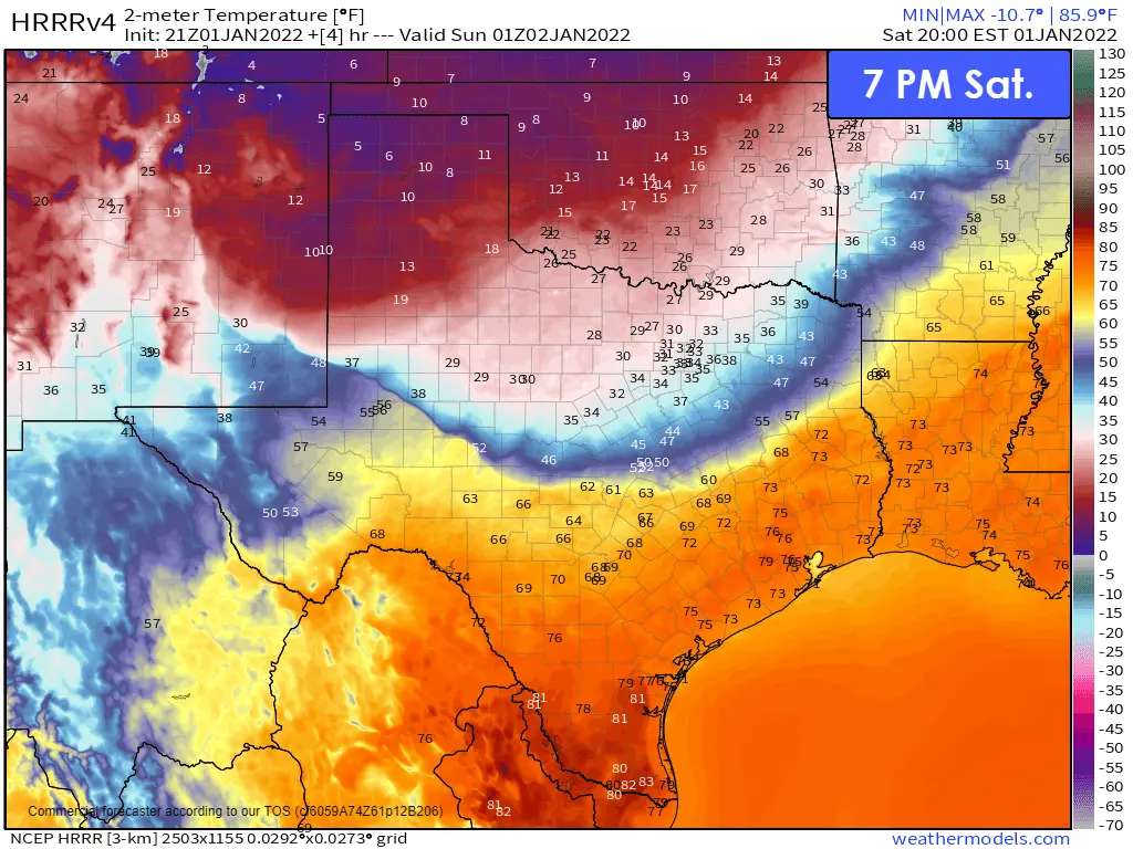
After a record-warm December, it appears Mother Nature has decided to welcome 2022 with a pretty gnarly arctic cold front. At 5 PM today, the cold front was near Seminole to Big Spring to Ballinger to Waco to Canton to Texarkana. Temperatures south of the cold front are well up into the 70s and 80s. Don’t yall worry, though; crashy the cold front will bring winter to the rest of Texas later tonight. Light snow is falling in the Texas Panhandle and West Texas – where temperatures are down into the single digits and teens. The front will continue to move south tonight steadily.
Ongoing Snow in West Texas & Panhandle
Ongoing light snow across the Texas Panhandle and West Texas may produce one to perhaps two inches of snow accumulation. The snow itself is moving east/northeast and will conclude this evening. Travel issues are being reported on Interstate 27 between Canyon and north of Lubbock, so it seems reasonable that road conditions will go downhill between Amarillo, Lubbock, Shamrock, and Childress. Temperatures will be in the single digits by morning, so don’t expect too much melting to occur.
Very Cold Temperatures Tonight for the northern half of Texas
Wind chill temperatures will range from near zero to the single digits from the Davis Mountains east to the Hill Country – and north. Below zero wind chill temperatures are expected by morning across the Texas Panhandle, West Texas, into Texoma. It’ll be pretty darn chilly down into South Texas by Sunday morning. Actual low temperatures will drop below freezing across the northern two-thirds of Texas tonight.
No comparison to last February’s week of hell
For those comparing last February’s temperatures to our current event, actual temperatures and wind chill temperatures will remain about 30 to 40 degrees warmer. We’re dealing with a ‘typical’ winter cold snap that’ll last about two days, not a week-long journey down the most frigid temperatures Texas has seen in 50-100 years.
Sunday through Monday Morning
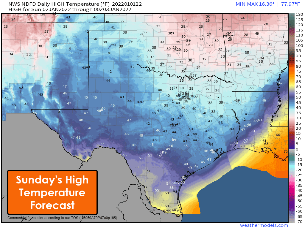
Temperatures will struggle to rise much above freezing on Sunday across North Texas, Texoma, and Northeast Texas. It will be a chilly and brisk day across Texas. High temperatures are shown across South Texas, and the Rio Grande Valley will occur around sunrise – with dropping temperatures for the remainder of Sunday. Gusty north winds will make it feel about ten to fifteen degrees colder than the actual air temperature.
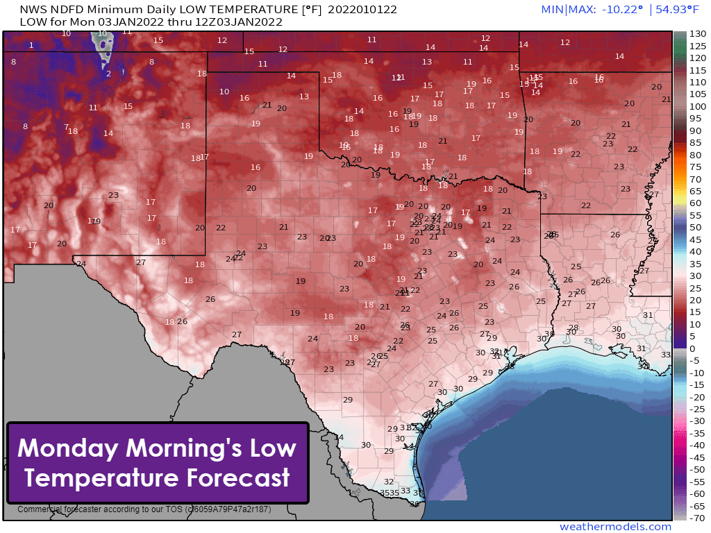
All of Texas, minus Laredo, McAllen, east to Brownsville, will experience freezing temperatures Monday morning. For most of Texas, temperatures will drop into the teens and twenties. A chilly night for sure, but again, we’re talking about temperatures thirty to fifty degrees above what we had back in February. Make sure you remember to bring your pets indoors, secure your outdoor water faucets, and all the usual cold weather routines.
Rebounding Temperatures on Monday & Tuesday
We’ll start heading up the temperature roller-coaster on Monday. A rapid warm-up will commence on Tuesday with high temperatures across Texas ranging from the upper 50s in Northeast Texas up into the middle 70s from the Big Country down into the Trans-Pecos and South Texas. Our warming trend will continue into Wednesday before another arctic cold front arrives late in the workweek. There are not any indications of winter precipitation with our late-week system.


0 Comments