
A particularly dangerous situation tornado watch has been issued for the eastern Texas Panhandle and far Northwest Texas. This is a PDS watch which means there is a significant risk of strong, long-lived tornadoes. This is easily the highest tornado risk the Panhandle has seen since November 16, 2015. Before that we have to go back several years into the late 2000s. Understood that this is a serious situation, but as long as you have a way to receive warnings and take shelter, you’ll be good to go! We’re chasing so this may be our last in-depth update until the event is concluded.
Advertisements
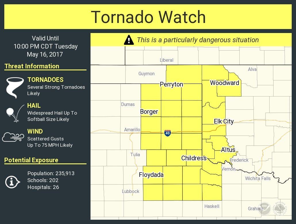
 Tornado Watch Number 220
   NWS Storm Prediction Center Norman OK
   150 PM CDT Tue May 16 2017

   The NWS Storm Prediction Center has issued a

   * Tornado Watch for portions of
     Western Oklahoma
     Eastern Texas Panhandle

   * Effective this Tuesday afternoon and evening from 150 PM until
     1000 PM CDT.

   ...THIS IS A PARTICULARLY DANGEROUS SITUATION...

   * Primary threats include...
     Several tornadoes and a few intense tornadoes likely
     Widespread large hail and isolated very large hail events to 4
       inches in diameter likely
     Scattered damaging winds likely with isolated significant gusts
       to 75 mph possible

   SUMMARY...Isolated supercell thunderstorms are expected to form
   along the dryline over the eastern Texas Panhandle and track across
   the watch area this afternoon and evening.  Very large hail and
   isolated strong tornadoes are possible in this area.

   The tornado watch area is approximately along and 55 statute miles
   east and west of a line from 75 miles south southwest of Childress
   TX to 55 miles north northwest of Gage OK. For a complete depiction
   of the watch see the associated watch outline update (WOUS64 KWNS
   WOU0).

   PRECAUTIONARY/PREPAREDNESS ACTIONS...

   REMEMBER...A Tornado Watch means conditions are favorable for
   tornadoes and severe thunderstorms in and close to the watch
   area. Persons in these areas should be on the lookout for
   threatening weather conditions and listen for later statements
   and possible warnings.


0 Comments