
A relatively low-probability severe weather threat is possible later today and again during the afternoon hours on Tuesday. Things begin to ramp up by Tuesday Night in West Texas before the risks move east on Wednesday and Thursday. After a week of quiet weather we’re shifting back into an active weather pattern. We’ll be sharing several severe weather outlooks in this blog and in the days forthcoming. Remember that these risks are drawn based on the probability of severe weather within a local region. You can learn more about how severe weather outlooks are created in our severe weather center.
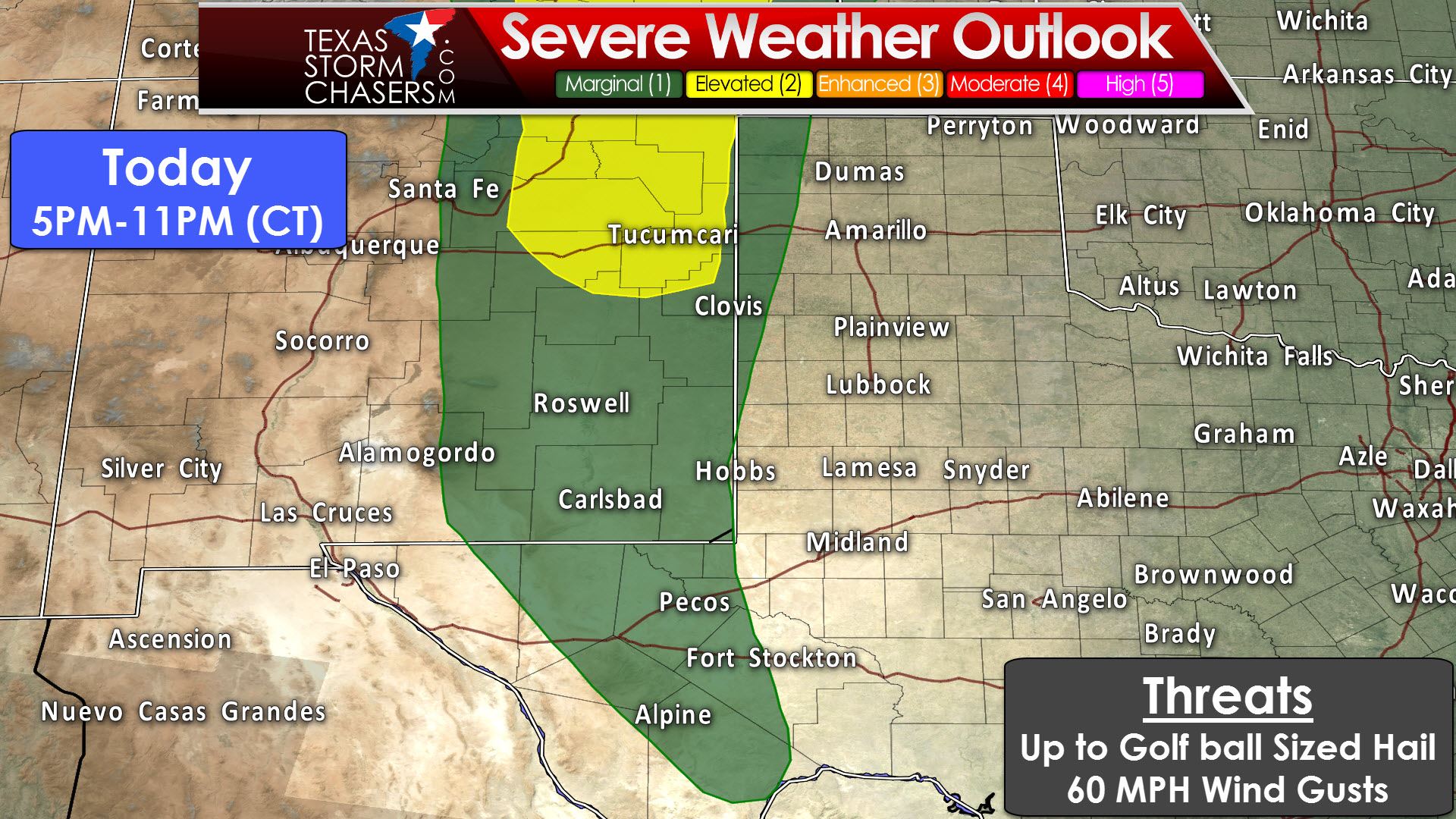
Today (May 8): Our first chance for severe weather will be late this afternoon in the Trans-Pecos northward into the extreme western sections of the Texas Panhandle. Alpine, Fort Stockton, Pecos, Bovina, Adrian, Dalhart, and Texline. Those locations are included in a “marginal” level 1 risk of severe weather. The higher probabilities for severe weather will be in eastern New Mexico into Colorado. We may see isolated storms fire up in the Trans-Pecos during peak heating late this afternoon. Those storms that do develop will be in an enviornment supportive of organized convection. Hail up to the size of golfballs and localized wind gusts over 60 MPH would be the primary severe weather threats. A slightly more likely zone for supercells may be from Roswell to Clovis to Tucumcari. Don’t be surprised if some impressive storm structure images/video come out of that area later on.

Tuesday, May 9: Severe weather chances will expand spatially into more of Texas on Tuesday. We could see two time-windows for potential organized convection. A “slight/elevated” level 2 risk of severe weather is in place across the Permian Basin, West Texas, and the southern Texas Panhandle. Fort Stockton, Pecos, Midland, Big Spring, Andrews, Seminole, Lamesa, Post, Bornfield, Morton, Lubbock, Ralls, Littlefield, Plainview, Tulia, Hereford, and Canyon are a few towns included. A “marginal” level 1 risk includes the remainder of the Texas Panhandle, western sections of the Big Country, the Concho Valley, Trans-Pecos, and Southwest Texas. Del Rio, Ozona, Sanderson, Alpine, San Angelo, Paducah, Shamrock, Amarillo, Dumas, Dalhart, Stratford, Perryton, Pampa, and Canadian are a few towns included.
Simulated Model Radar at 7 PM Tuesday from 12Z 3KM North American Model
The first round of potential storms may come in the late afternoon hours in eastern New Mexico and western sections of West Texas and the Permain Basin. There remains some uncertainty on the number of potential storms in this timeframe. About 5PM through 9PM will be the time-frame for discrete supercells. The strongest of those supercells could produce large hail and localized damaging wind gusts. The tornado threat looks low, but not totally zero. We could see low-level shear enhanced by any residual outflow boundaries left over from today’s storms. By the mid-evening hours we may either see these storms dissipate – or they may be the first of a growing complex/squall line. That leads us into round two.

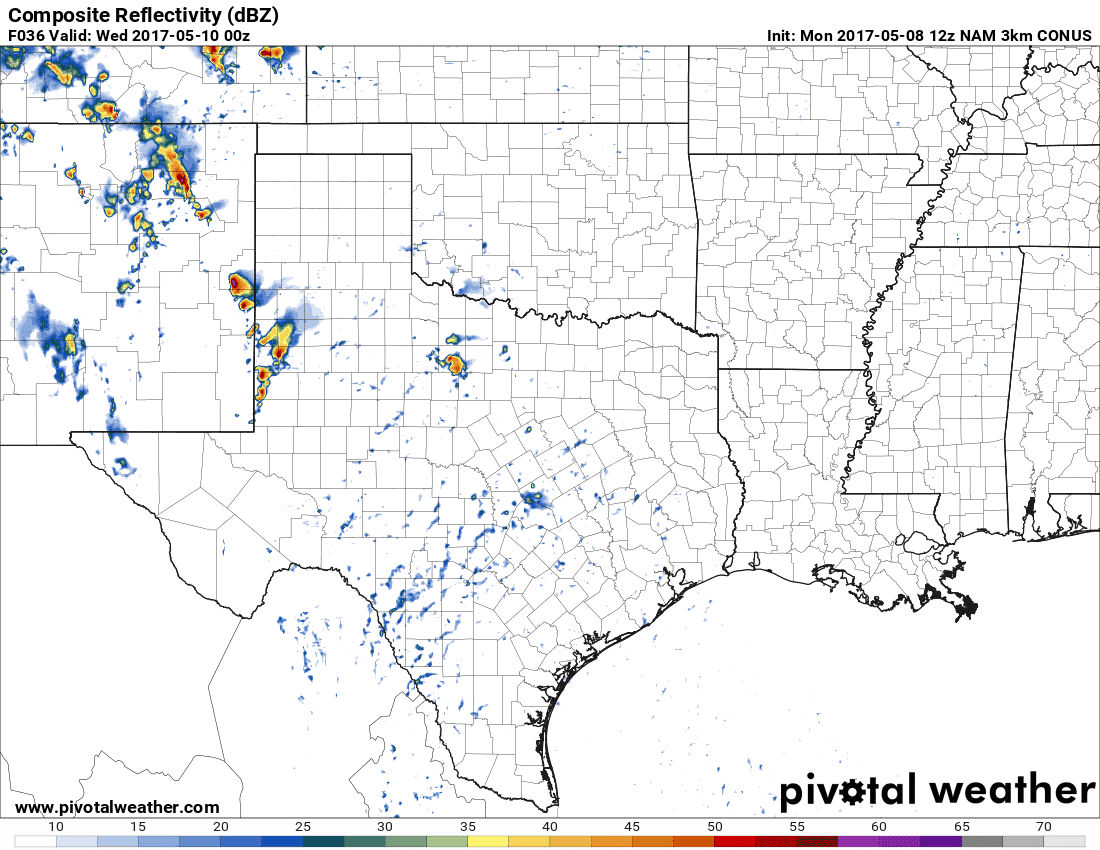
Simulated Model Radar at 3 AM Wednesday from 12Z 3KM North American Model
Tuesday Night/Wednesday Morning: The second round of storms will be more widespread and could be where the most severe weather reports are received. This threat will be during the late evening hours Tuesday into the predawn hours Wednesday. A squall line or cluster of thunderstorms will likely develop in eastern New Mexico or far western sections of West Texas. This area of thunderstorms will move east/northeast across the Texas Panhandle and West Texas early Wednesday morning. Some storms in the squall line may produce damaging wind gusts and hail. The threat for severe weather will decrease by sunrise, but storms will continue to move east/northeast through mid-morning. They should exit the Texas Panhandle and move into Oklahoma by 9-10AM. Localized minor flooding is possible in the typical trouble spots (poor-drainage, farm roads, etc). This isn’t a big flood maker, but folks should be able to wrangle out one-half to one inch of rain. It is not out of the realm of possibility that the squall line extends farther south then the simulated radar images above show. Should that southward extension occur the threat for some gusty winds would include Northwest Texas and western North Texas. Those risk zones are included in the severe weather outlook below.

Wednesday, May 10: The severe weather outlook for Wednesday starts up at 7 AM and does include the possibility of some gusty winds with the morning squall line in Northwest Texas and western North Texas (should the squall line be in progress that far south). We’ll see a lull in severe weather chances late Wednesday morning through the mid-afternoon hours. This is the time frame where we may see the atmosphere destabilize behind the first round of storms. A risk of new severe thunderstorm development is possible by the late afternoon hours Wednesday in the eastern Texas Panhandle into Northwest Texas. This afternoon risk will be dependent on how quickly morning storms can clear out. If we see morning rain/clouds stick around longer, the severity of the afternoon storm chances may decrease. If we get several hours of sunshine after the morning storms then we’ll see a higher threat of discrete storms in the afternoon. Those factors won’t be clearly determined until we’re within 12-24 hours. The Storm Prediction Center has a “slight/elevated” level 2 risk of severe weather in place across the eastern half of the Texas Panhandle and Northwest Texas. Stamford, Seymour, Vernon, Spur, Paducah, Childress, Shamrock, Pampa, Stinnett, Gruver, Perryton, and Canadian are a few towns included. A “marginal” level 1 risk includes the central Texas Panhandle, West Texas, the Big Country, Concho Valley, Southwest Texas, and western North Texas. Del Rio, Sonora, Junction, Big Lake, San Angelo, Brady, Brownwood, Midland, Abilene, Post, Graham, Gainesville, Wichita Falls, Lubbock, Hereford, Amarillo, Dumas, and Dalhart are included in this risk. The extent and aerial coverage of Wednesday’s severe weather threat will be dictated by the morning convection. Expect changes in future severe weather outlooks as spatial and mesoscale features become more clear.
Isolated supercellular development is possible across the eastern Texas Panhandle and Northwest Texas late Wednesday afternoon. These storms would fire up just east of a sharp surface dryline. The eventual position of that dryline will dictate the western edge of the severe weather risk. A strong upper level jet-steak is anticipated to be entering the region right around 4-7 PM. Combined with an increasing low-level jet we should see an enviornment supportive of organized storms. Very large hail, localized damaging winds, and a tornado threat would be possible. There remain several caveats that will need to be worked out as we get closer to Wednesday afternoon’s setup. Storms that develop will tend to move east/northeast. A strong cap will limit southward development further down the dryline, but models tend to do poorly on how far south storms can develop. Assuming we get several hours of good heating in Northwest Texas and the Big Country I wouldn’t be surprised to see isolated storm development occur down to Interstate 20 on the dryline. Those storms that do develop would also be severe with a risk of very large hail. We’ll have to see if we can get another late-night cluster of storms in Southwest Texas and the Concho Valley, but that potential looks low at this time.
Thursday, May 11: If the next three days weren’t enough to discuss we have to look ahead to Thursday as well. Our strong upper-level jet will still be in place. The dryline by late Thursday afternoon could be near Highway 281, although the exact positioning is still to be determined. It will be locations along and east of the dryline that will need to be watched for isolated to scattered thunderstorm development. Isolated to scattered severe storms are likely across portions of North Texas by late Thursday afternoon into Thursday evening. The strongest storms may produce very large hail and localized damaging wind gusts. Weak low-level shear looks to keep the tornado threat low, but we’ll have to watch for any boundaries or other mesoscale features that could enhanced the tornado threat. Regardless, the primary hazard looks to be damaging hail. Yesterday’s weather models had the dryline just west of I-35/35W. This morning they’re closer to Highway 281. Either solution would have the D/FW Metroplex in the risk zone. Not everyone is going to see severe storms, but I think we are going to have issues. Isolated storm development is possible all the way south into Central Texas and the Hill Country just ahead of the dryline – those storms also being severe with large hail. A squall line or cluster may develop and move east/southeast as a cold front arrives late Thursday Night into Friday. Being four days out there remain numerous questions, so expect changes to the forecast. I wouldn’t be surprised to see portions of Thursday’s severe weather outlook upgraded down the road as confidence in where the highest storm coverage increases.


0 Comments