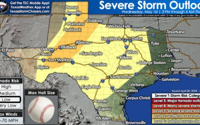
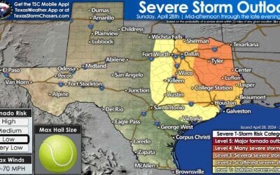
One knows fall has arrived when the weather in Texas starts to get active after the summer doldrums. That’ll be very much the case over the next week as we deal with the potential of impactful weather each day. Heavy rains and severe storms will be dual hazards. The good news is the rains will be across areas that actually need it (farther west and north than earlier than last month). Unfourtinietly, some droughts do end in a flood. That’ll probably be the case too this weekend and next week. Severe thunderstorms could also be an issue, especially by Monday and Tuesday as our upper-level storm system begins to move east. Remember, not everyone is going to get rained on, have a flood, or get hit by severe storms. Someone will always be the one to ‘get left out’.
Heavy Rain and Flooding Threats
Several episodes of heavy rain will bring an increasing threat of flooding to parts of Texas in the coming days. Flash flooding will be the initial concern, but river flooding will be a longer-term threat next week in and downstream of the heavy rain zone. This could be a particular hazard to agricultural interests who may have livestock in low-lying areas or adjacent to rivers. This will be a frog-strangler, gully-washer, or your personal favorite term for a good soaker.
Through tonight the most probable corridor of localized flooding will be in proximity of a slow-moving cold front from the Permian Basin and Concho Valley northeast through Texoma and into Oklahoma. I don’t think we’ll see widespread flooding tonight, but any rain that falls now will only make it harder for the ground to soak up the heavy rains to come.
A moderate risk of flash flooding has been issued for West-Central Texas, the eastern Texas Panhandle, and far Northwest Texas for Sunday and especially Sunday Night. A slight and marginal risk of flash flooding surround the moderate risk and include portions of the Permian Basin, West Texas, and the remainder of the Texas Panhandle. A moderate risk means flash flooding is probable, with localized significant flooding possible.
A moderate risk of flash flooding is also in effect for Monday across West Texas, the eastern half of the Texas Panhandle, into portions of Northwest Texas. The eventual corridor of heaviest rains and highest flood potential may be shifted a bit to the west or east, but flooding will probably be underway by Monday due to continuing heavy rainfall. Not everyone will see flooding, but some locations will already have seen five inches of rain by Monday morning. Not only will we have to watch for flash flooding (rapidly rising water), but a longer-term issue of river flooding will continue through all of next week in the heavy rain zone and downstream.
The risk of flash flooding will continue into Tuesday, but spread east toward Interstate 35 as our upper-level storm system finally begins to get a move on. River flooding is probable and would continue through all of next week (and beyond) as flood waters move downstream through their respetive basins. A great resource to track all things water in Texas is with the Texas Water Dashboard from the USGS.
How much rain could I get?
On a regional level, I’d guesstimate to say this could be the most impressive rain event the Panhandle and Northwest Texas have seen since the fall of 2015. That’s just from my personal recollection and I’m sure the scientific data would dispute that, but alas. Widespread rain totals across the Texas Panhandle, West Texas, and Northwest Texas should range from 1 to 2 inches all the way up to 5 to 7 inches. We note that some data suggests rain totals could approach 8″+ in localized spots in the eastern/southeastern Texas Panhandle, Northwest Texas, into western Oklahoma. That kind of rainfall isn’t seen too often in a 2-3 day span in those parts, so flash flooding is a significant concern.
Rainfall amounts of 1 to 3 inches across North Texas, Central Texas, west into the Hill Country and Concho Valley. Some will see far less and some may see more. These graphics are meant to convey potential rains on a regional basis and obviously can’t take into account how much rain a specific blade of grass in your backyard might receive.
Severe Thunderstorm Threats
Severe thunderstorms will be possible each day through at least Tuesday. There are a few factors that will dictate the scope of each day’s severe weather threat and potential localized zones of enhanced potential. The more sunshine a risk area receives the higher the chance of severe storms. Wind shear will be ample and supportive of organized thunderstorms throughout this event. A primary question for each day is how much instability will be available. More clouds and more rain would help keep the threat lower and/or isolated.
Ongoing severe weather through this evening and Sunday
Severe storms ongoing in the Trans-Pecos and Permian Basin at the time of this writing will primarily be hail and localized damaging wind producers. Tomorrow’s severe weather threat looks to be highest in eastern New Mexico and far West Texas. There could be a low-end tornado risk introduced tomorrow there, but hail/wind should still be the primary severe threat. Isolated stronger storms with hail are possible across the western half of Texas (areas south of the cold front) both tonight, on Sunday, and especially on Monday.
Severe weather threat expands on Monday
Monday’s overall severe weather threat still has several caveats that could reduce or enhance the overall event. If widespread precipitation keeps the atmosphere from becoming overly unstable the threat of severe weather would be limited. A strong high pressure over the eastern United States is going to keep the upper-level storm system responsible for all this from moving too quickly over the coming days. Exactly where that system is on Monday will help dictate the position of surface fronts. Mainly, the dryline’s position as the threat of severe storms would be along and east of the dryline. Those of you who checked in with us a few days ago may notice this system has ‘slowed down’, thus instead of a Saturday/Sunday, we’re now looking at threats well into Tuesday.
The dryline/cold front marches east for more severe storms on Tuesday

Tuesday’s extended-range severe weather outlook. Expect refinements to this as we get into Sunday and Monday.
A linear storm mode on Monday would result in damaging straight-line winds and brief tornadoes being the primary severe threats. If we had a mixed mode of line segments and semi-discrete supercells we’d have all modes of severe weather possible, including the possibility of a couple of tornadoes. The same goes for Tuesday as the risk of severe weather moves into Northwest Texas, the Big Country, the Concho Valley, east into Texoma and North Texas. We’ll be able to refine those zones once we get closer to Tuesday. The upper-level lift will be quite strong along with wind shear values on Sunday, Monday, and Tuesday.
Future Tropical Storm Michael throwing a forecast curveball
Another interesting curveball is the soon to be Tropical Storm Michael near the Yucatan Peninsula. That system will not approach Texas thanks to the strong upper-level storm system that is bringing us all the active weather. However, as the system organizes and moves toward the northern Gulf Coast in a few days, it may actually help low-level winds across Texas to become more southeasterly or easterly. That ‘curvature’ of southeast or easterly surface winds, veering to the southwest as you increase in height could actually cause an increased threat of some tornadic mischief. That potential may become evident on Monday and Tuesday closer to Interstate 35 across Central and North Texas. That’ll be something we’ll watch for closely.
Looking ahead to late next week
After this multi-day system moves out we should have a day or two of calmer weather before our next system could bring more rains. Hurricane Sergio in the eastern Pacific is expected to impact Baja California in the middle of this upcoming week. After landfall, the general upper-level pattern would suggest that remanent moisture and energy from Sergio could move toward Texas. That possibility would bring another round of heavy rain and potential storms to various parts of Texas. It is way too soon to speculate on any flooding or severe possibilities, but keep this tidbit in the back of your mind until we get this first system out of the way.


0 Comments