

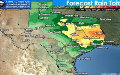
Temperatures across most of Texas have warmed into the lower 90s at the lunch hour. The exception is out in the Permian Basin and Far West Texas where clouds have kept temperatures cooler. With temperatures now in the 90s any cap we’ve had this morning is just about gone. You can tell that by the rapidly increasing cumulus clouds on visible satellite. In fact we now have several showers and thunderstorms developing across the state. These first storms will produce outflow boundaries and help fire up even more storms through the afternoon. A rapid increase in thunderstorm coverage is expected by 2 PM. The strongest storms may produce strong microburst winds up to 60 MPH, locally heavy rain, and frequent cloud to ground lightning. Any one storm shouldn’t last longer than an hour since wind shear values in the atmosphere are non-existent. An Individual storm will go up quickly, peak, and quickly weaken in a 45 minute period. Its when the storms are collapsing when we have to be concerned about the strong wind gusts. Storms will continue into the early evening before coverage goes downhill.
0 Comments