
The weather highlight today will be the risk of a few strong to severe storms across parts of north central and northeast Texas later this evening and into the early overnight hours. Moisture and clouds have already begun to stream northwards out of central Texas this morning. As we get into the early afternoon hours, scattered showers are expected to develop across south central and central Texas, then build northward into the late afternoon and evening hours as a piece of upper level energy arrives. Best chances for strong to severe storms will be in the Marginal Risk area mainly to the east of the I-35 corridor…southeast from a Paris to Killeen line. Marginally severe hail (up to 1 inch) will be the greatest threat along with lightning and gusty winds. Thankfully, the threat of tornadoes is pretty much zero as these storms will be more elevated in nature.

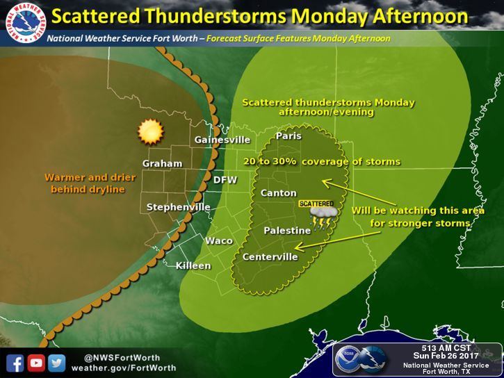
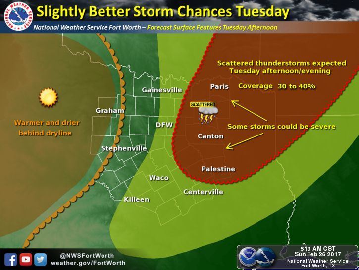
Looking ahead to Monday and Tuesday, additional rounds of storms are expected each afternoon and evening with Tuesday carrying the greatest threat for seeing severe weather. Once again, this will pertain to residents along and east of the I-35 corridor. Monday’s storm potential looks pretty scattered, but any storms that do form have the potential to become strong with a marginally severe hail threat, frequent lightning and gusty winds. Tuesday, as stronger upper level lift arrives, storm coverage is expected to be greater with the best chances across northeast Texas. The most severe weather on Tuesday is expected to remain northeast of our state…across central and northern Arkansas…but we’ll still have the chance for seeing strong storm development along the dryline Tuesday afternoon with the threat of large hail and damaging winds. Timing is still being worked out with regard to the arrival of the best upper level energy on Tuesday, which could make a significant difference in the timing of storms, so it’s likely that we’ll see some updates between now and early Tuesday.
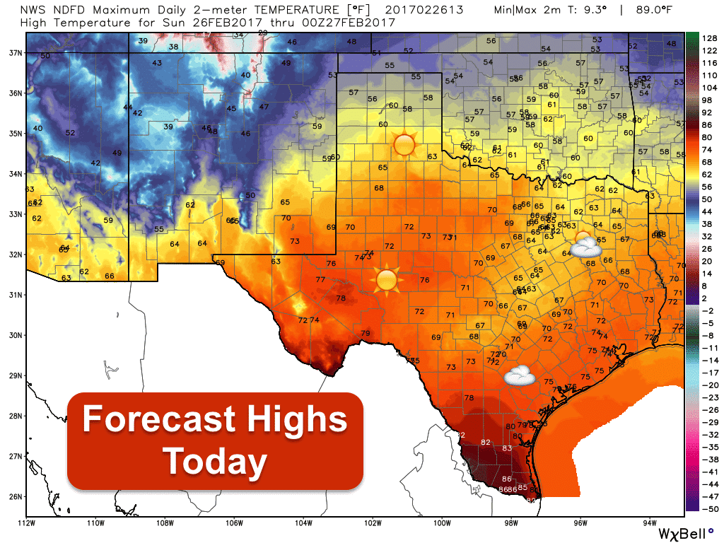
For today…pleasant highs with increasing clouds across south central and central Texas which will stream northward through the afternoon hours. Temperatures today will be fairly seasonal. Lows overnight will be pretty close to seasonal as well. Tomorrow and Tuesday, we heat up again to levels well above normal for this time of the year. Although we still have a few more days left in February, it’s highly likely that we’ll end up with the the winter of 2016-17 (Dec, Jan, Feb) being the warmest on record across much of the state. Before anyone screams global warming, just remember the winter of 2013-14 when we ended up in the 20th coldest (DFW area) and had the most freezes we’d seen in over 30 years. Just goes to show you how variable our seasons can be here in Texas year over year!
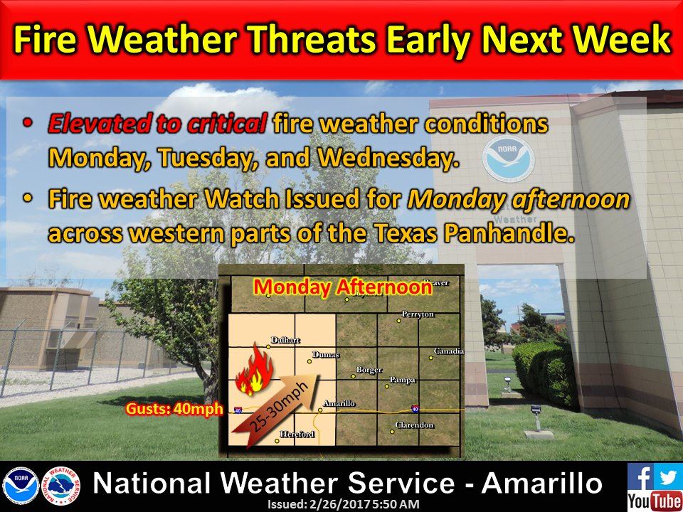
Last but not least, we’re not done with the threat of wildfires across western Texas over the next several days. Gusty winds and low humidity values will remain in place over the next several days with winds increasing each afternoon across far western Texas up into the panhandle region through Tuesday. Red Flag Warnings are in place today for the El Paso region. Monday through Tuesday, we’ll likely see that threat extended north into eastern New Mexico and the western Texas panhandle. Last week, we saw one fire break out northeast of Amarillo which ended up burning over 7,000 acres before it was extinguished. Another fire south of Amarillo destroyed 3 homes and a community water well. That fire was sparked while a resident was attempting to cook on a backyard grille. We can’t say it enough, please heed these Red Flag warnings and exercise some common sense by avoiding any activity that could cause a spark or flame.


0 Comments