
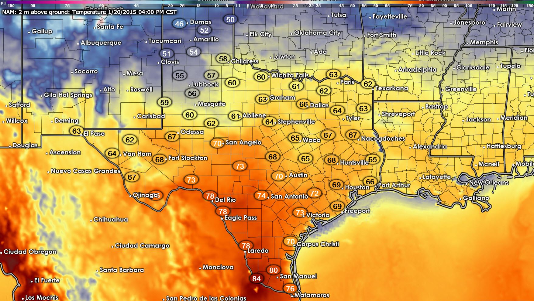
Good Morning Texas and welcome to your Tuesday morning weather roundup! Clouds will move out of our state by this afternoon resulting in mostly sunny skies for all. Today will be the calm before the storm as big weather changes are on the way. We’re going to see a forty degree temperatures difference later today with 40s in the Panhandle and 80s across South Texas. At least skies will be mostly clear. Here’s a comprehensive list of today’s forecast high temperatures for cities across the state.
Austin: 72F
Beaumont: 72F
Bowie: 62F
Breckenridge: 64F
Brownsville: 79F
Childress: 57F
Corpus Christi: 75F
Dumas: 49F
El Paso: 68F
Falfurrias: 79F
Freer: 81F
Galveston: 67F
Haskell: 61F
Houston: 73F
Junction: 78F
Kingsville: 79F
Longview: 68F
Lubbock: 60F
Lufkin: 71F
Midland: 67F
Mount Pleasant: 66F
Odessa: 68F
Palestine: 69F
Paris: 64F
Plainview: 54F
Rio Grande City: 81F
San Angelo: 72F
San Antonio: 76F
Sherman: 63F
Sonora: 74F
Spur: 55F
Tyler: 67F
Victoria: 78F
Wichita Falls: 60F
Zapata: 81F
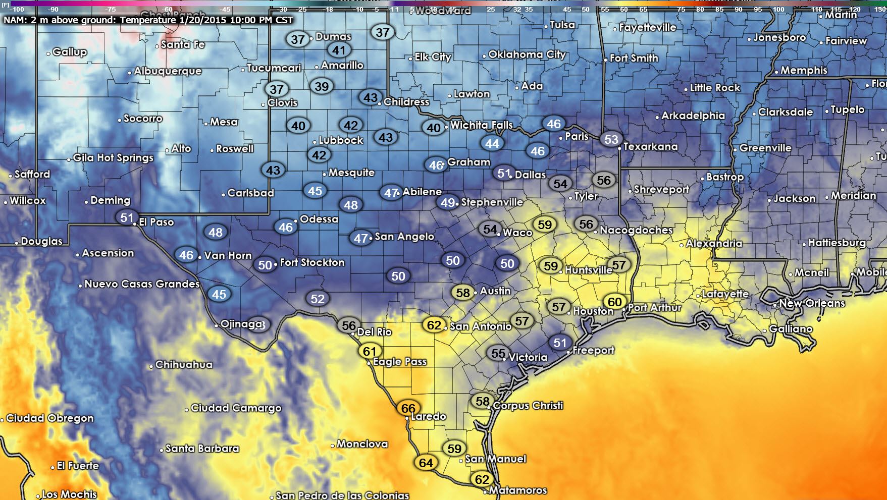
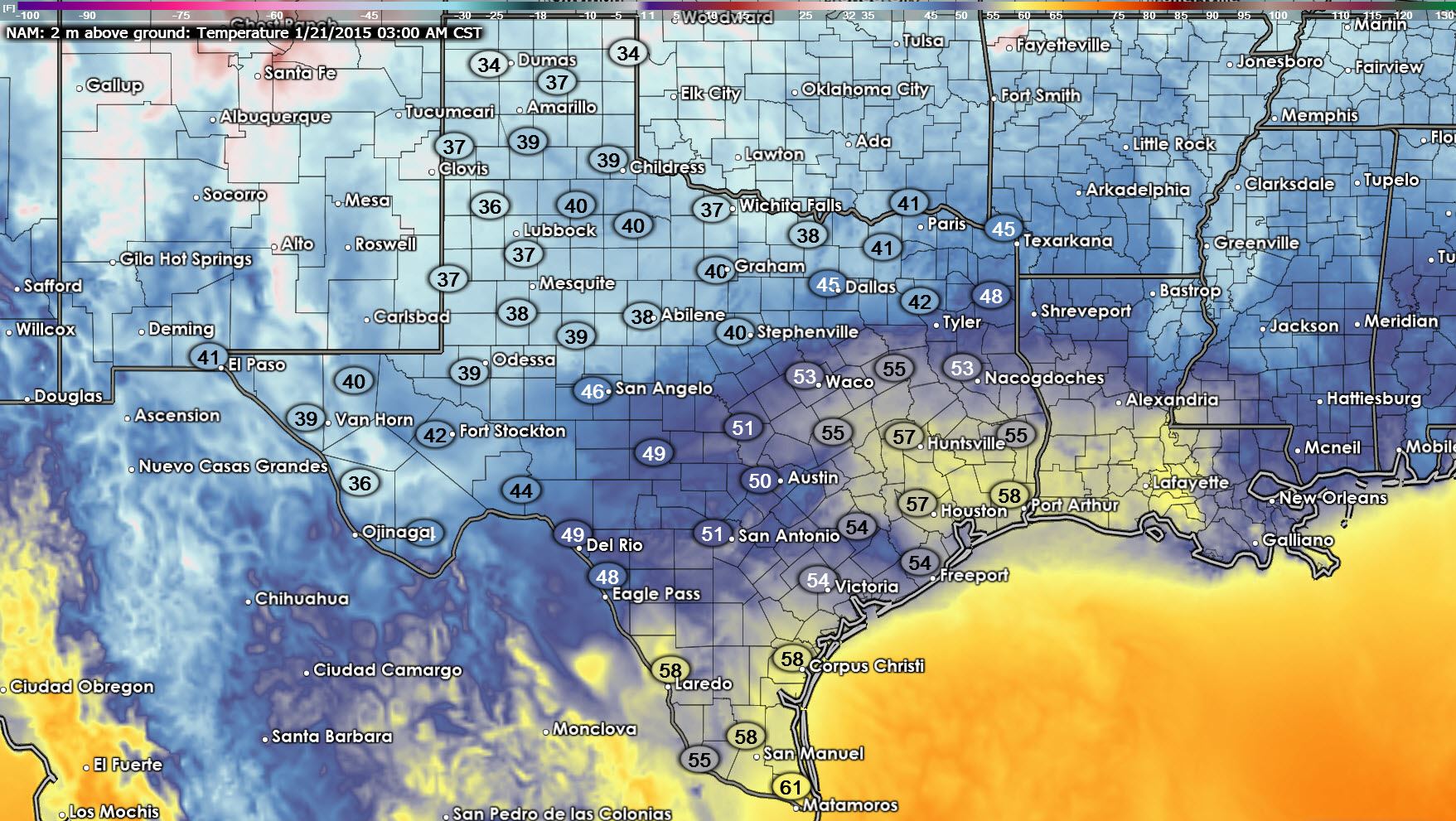
Clouds will increase across Texas tonight as moisture moves in ahead of our Wednesday Night through Friday storm system. Temperatures will be typical of January nights with the coldest temperatures in the north with the warmest temperatures along the coast and in the Rio Grande Valley. Here’s a look at how temperatures will progress this evening into the overnight hours from the North American Model.
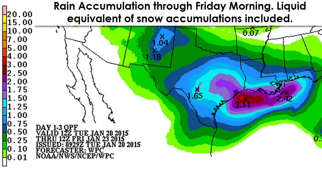
Our main focus this morning is on the increasing potential for a winter storm in the Texas Panhandle and South Plains beginning Wednesday Night and continuing into Thursday. Last night’s weather model data came in with more moisture and a tad cooler. Thus the forecast snow accumulations will need to be increased as well. We still believe the western Texas Panhandle will see the most snow accumulation which could top out near 6 inches with lighter accumulations in the Central and Eastern Panhandle into the South Plains. I’m not going to post an accumulation graphic with this morning’s post because I want to wait until this afternoon so we’re within 30 hours. If models continue to trend higher with precipitation totals then snow accumulations will need to be increased again across the Panhandle and South Plains. I do anticipate travel impacts will develop late Wednesday Night into Thursday across the Texas Panhandle and South Plains especially in areas that see heavy snow.
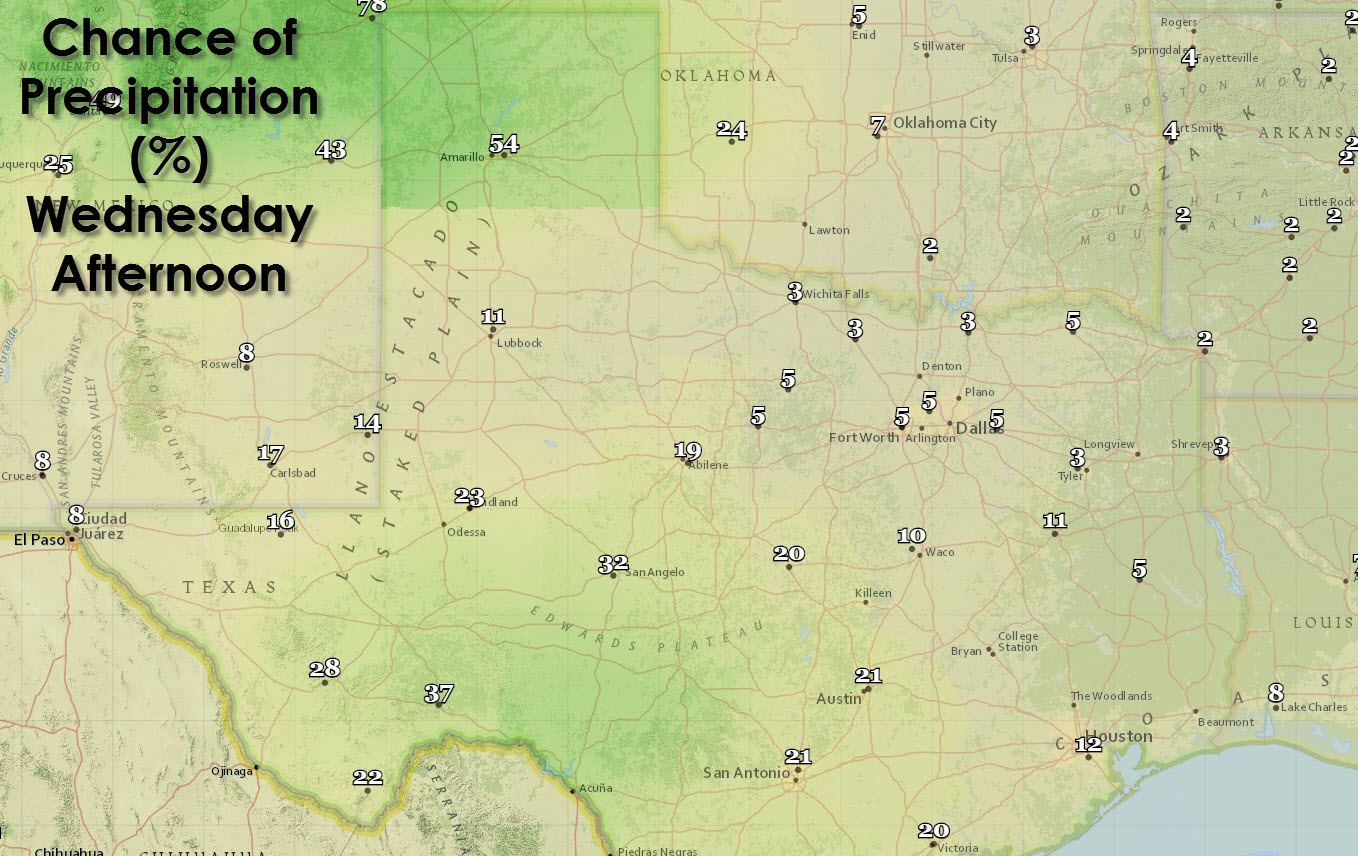
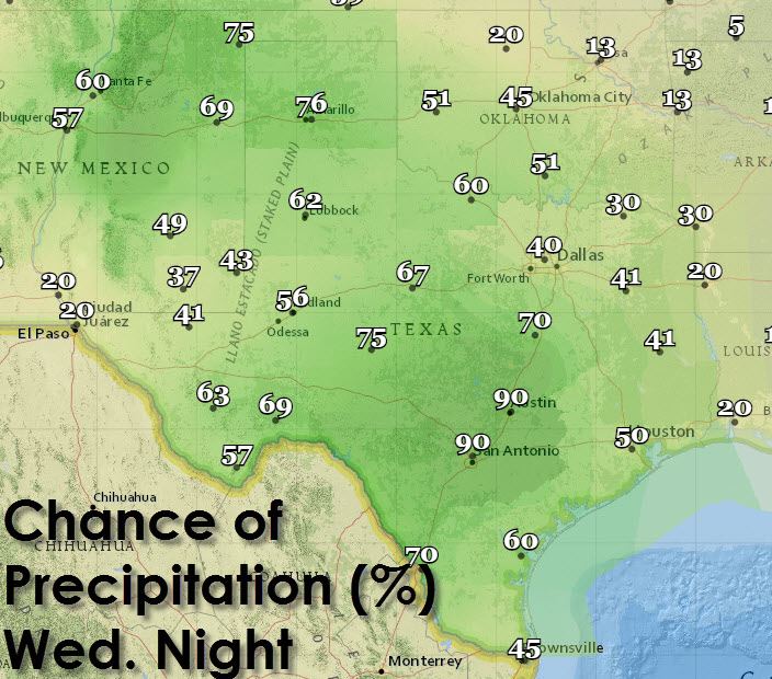
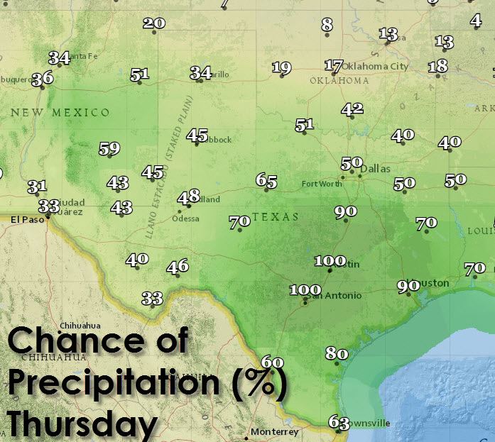
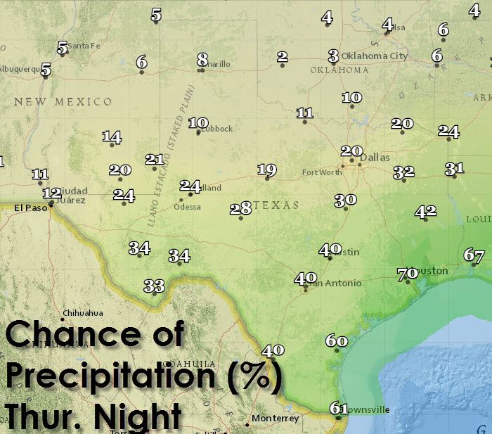
Temperatures at the surface will be too warm to support winter precipitation across North, Central, South, East, Northeast, or Southeast Texas. Rain accumulations of 1 to 2 inches will be possible through Friday morning. Flooding and severe weather is not expected. We may see a brief opportunity for light snow across western portions of North Texas and Northwest Texas on Thursday as colder air filters into the region. At this time surface temperatures are expected to remain above freezing with little snow accumulation expected. We’ll be watching data closely today just in case the system comes in cooler and we need to adjust that snow line into parts of West-Central and Northwest Texas from the Panhandle. I’m very confident in saying there will be no winter weather accumulations or impacts in the I-35 cities in Texas even if we end up a tad bit cooler. We’d have to see a massive shift in weather model guidance and I simply don’t expect that to happen.
This is a fluid situation and some changes can be expected as we continue to refine the forecast. Please check back later today for the latest forecast regarding snow chances for the Panhandle and South Plains and rain chances elsewhere. We’ll keep you updated on our website along with our social media platforms.


0 Comments