
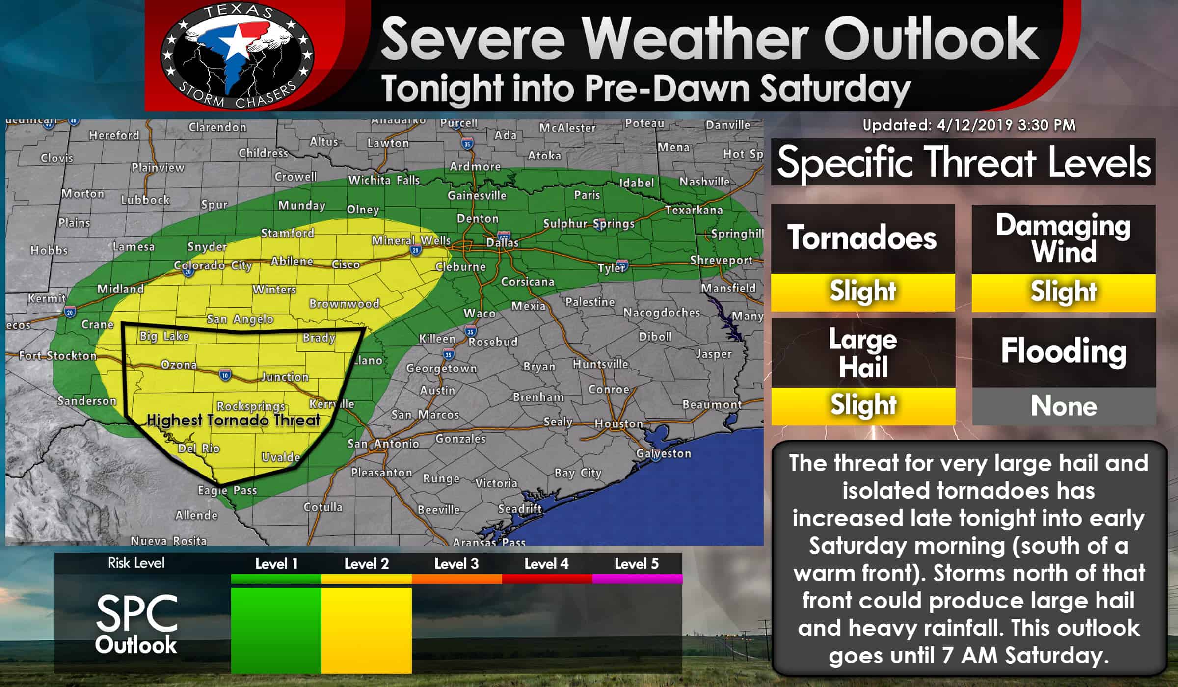
A level two risk of severe weather includes the Edwards Plateau, Concho Valley, eastern Permian Basin, Big Country, and western North Texas tonight and into the morning hours on Saturday. Isolated thunderstorms may develop as soon as dinner-time across West-Central Texas. Those storms could have hail, but the primary threat of severe weather is not expected until around or after midnight Saturday.
Thunderstorms will increase in coverage as upper-level lift arrives. These storms will initially fire up in the eastern Permian Basin into western sections of the Concho Valley. Large hail will be likely with the strongest storms. Those storms will likely grow upscale into a cluster or line as they move east into the Big Country and western North Texas by 6 AM. An isolated tornado cannot be ruled out in the southern Concho Valley or in the Edwards Plateau (south of a warm front). We note that showers and storms will also be underway across Northwest Texas, Texoma, and North Texas early tomorrow morning. Some of those storms may become strong and produce hail.
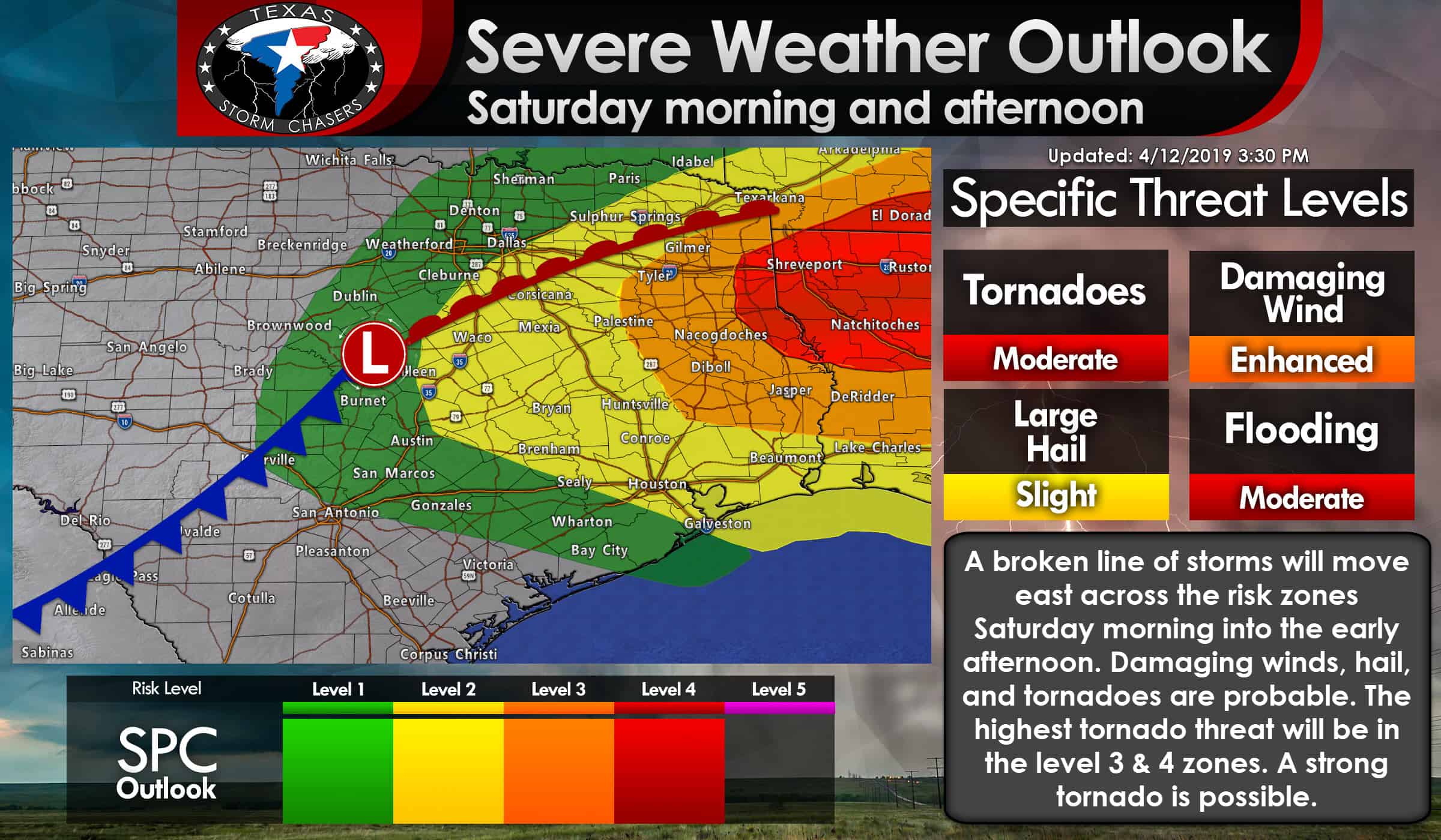
An area of low pressure will organize tomorrow morning in the Hill Country. A surface warm front will lift north to the east of that low pressure. The result will be increasing surface dewpoint values along with instability values across East Texas tomorrow morning. How far north that front goes by lunch-time will be important to determine the northward extent of any tornado risk. Storm mode will also play a role in specific severe weather threats. Discrete storms in the level 3/4 risks could have a significant tornado risk. A line of storms will move east across all four risk zones tomorrow morning into the mid-afternoon hours (in Texas). Damaging winds, hail, and brief tornadoes are possible. If the squall line ends up being more of a broken line of storms we would see the threat for tornadoes increase, in addition to any storms that form out ahead of that line.
I’ll be honest here. Ingredients will be in place to support a severe weather outbreak tomorrow morning into the afternoon across East Texas. A big reason we’re not calling for a major tornado outbreak is that we’re not sure we’ll get many discrete storms in East Texas. The potential for discrete/semi-discrete supercells seems to be higher just east of the Texas/Lousiana state line. Ingredients in East Texas will support a significant tornado risk *if* storms are able to take advantage of them. A line of storms will produce all modes of severe weather, but the threat for longer-lived/significant tornadoes would be higher with semi-discrete or discrete storms. We’re going to keep a very close eye on this, but as of now, we continue to think that threat will be higher in Lousiana and Mississippi.
The key message is that there is a substantial severe weather risk across East Texas from 10 AM to 4 PM. All modes of severe weather will be possible. A strong tornado cannot be ruled out. If this system ‘slows down’ or it becomes apparent that discrete storms will develop earlier (in Texas versus later in Lousiana) the potential for signfiicant tornadoes will increase. Ingredients will be in place to support a severe weather outbreak. Have multiple ways to receive weather warnings and know where you’ll go if dangerous weather approaches. Click here for tornado safety tips.

18Z HRRR Simulated Weather from 7 PM this evening until 7 PM Saturday. This is only a simulation from a weather model. Things could change, but severe weather is likely.


0 Comments