
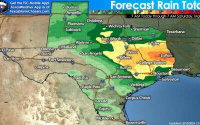
Scattered thunderstorms impacted the Texas Panhandle overnight. At the time of this writing a strong storm was moving southeast into Childress. Other showers are near Plainview to Vega. This activity is not severe and is not expected to become severe this morning. A few spots have picked up over an inch of rain. We’ll have a rain accumulation graphic later this morning. Other storms are just off the Southeast Texas and Coastal Plains coastline. Folks down there are getting a nice lightning show.


The main weather story for the next few days will be increasing heat levels. The upper level heat ridge is building back in after temporarily shifting into the Southwest US earlier this week. Afternoon high temperatures will climb back into the middle 90s to mid 100s over the next five days. Heat index values look to become oppressive by Sunday into Monday with values of 105 to 110 degrees possible along/east of Interstate 35. Isolated afternoon storms will be possible each afternoon but most folks will stay dry. Depending on activity in the Central Plains we may have one or more weakening thunderstorm complexes impact northern sections of Texas at points over the next week. Those chances will be determined each day and really depend on what happens 300+ miles upstream. Otherwise our typical summer weather in Texas continues with the next week looking hot and humid.
0 Comments