
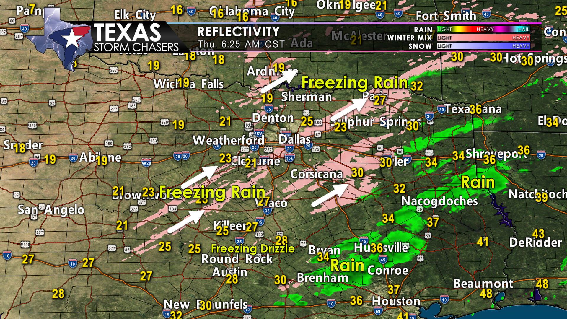
This morning, freezing drizzle is making a mess of things across the Hill Country, Central Texas, the northern Brazos Valley – all the way north to the Red River from Childress to De Kalb. The freezing drizzle is too shallow and weak to be detected by weather radars. We are seeing pockets of heavier freezing rain and sleet develop across the eastern half of North Texas into Northeast Texas. You can check on road conditions in your neck of the woods on the TxDOT Road Conditions website at DriveTexas.org.
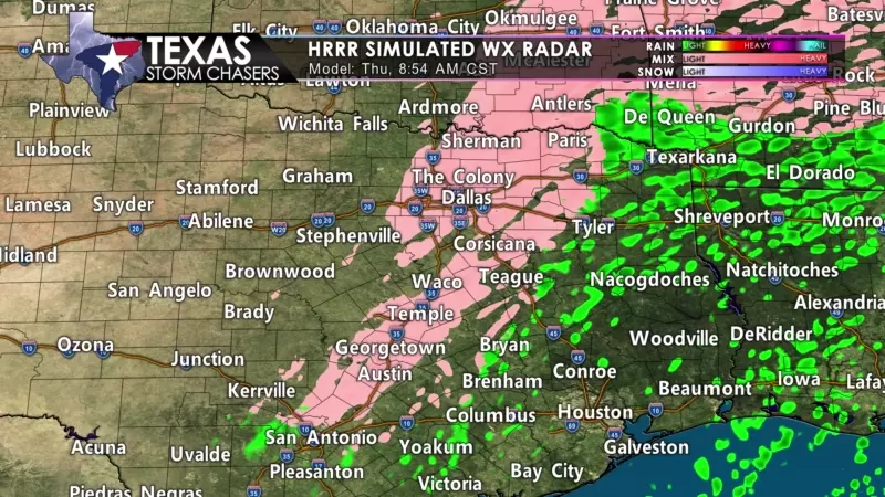
As far as additional ice accumulations – we’re anticipating the freezing drizzle to continue through the late morning hours. We should start drying out from west to east this afternoon as the upper-level lift departs. The wintry rain/sleet showers will be most likely from the D/FW Metroplex and Gainesville east into Northeast Texas through 2 PM. Up to 0.1″ inches, or 1/10th of an inch, of freezing rain accumulation, are possible, along with some sleet, for folks who end up under those heavier ‘showers’ or bands.
We’re not expecting a significant ice storm, but we indeed are experiencing slick roads. It may not look like winter outside, but the drizzle is causing problems. For those asking, yes – we did expect more in the way of ‘heavier freezing rain and sleet’ in North Texas overnight. However, there’s still enough freezing drizzle to cause problems.
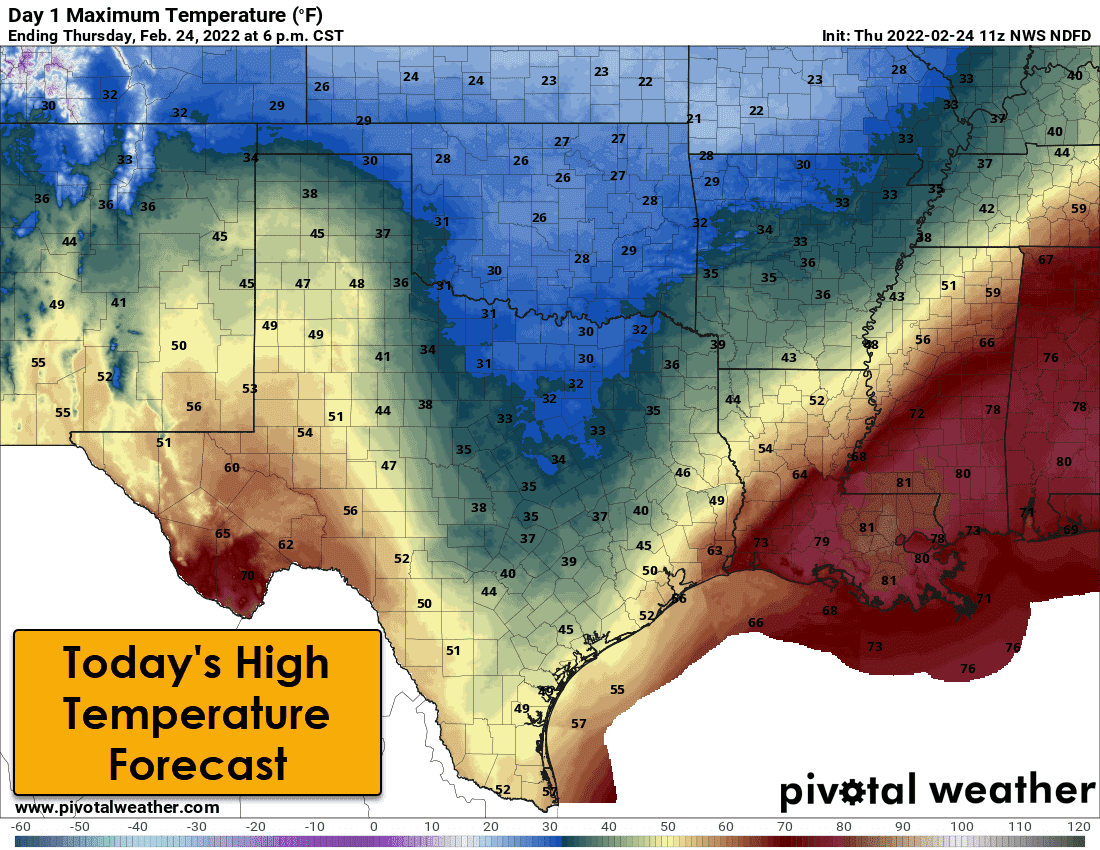
Winter precipitation will conclude by mid-afternoon as precipitation moves northeast into the ArkLaTex – and temperatures rise above freezing in those areas. We are going to see temperatures climb this afternoon. Several regions that are below freezing this morning will climb above freezing this afternoon. We should see some sublimation (melting) occur thanks to the wind, even for folks who stay below freezing. This afternoon, travel conditions should improve as roads start thawing out and road crews continue treatment. Any water or slush on roads will refreeze after sunset as we lose the afternoon ‘sun’ and temperatures dive back below freezing.
Heading into the weekend
We’ll be gradually warming up across Texas tomorrow and on Saturday. Rain chances return to the eastern two-thirds of Texas on Saturday as another upper-level storm system moves overhead. Rain totals will remain below one inch. One-quarter to three-quarters of an inch of rain is possible across North Texas, Central Texas, the Brazos Valley, and across East Texas and the ArkLaTex. Temperatures Saturday morning are expected to be near or below freezing in the Big Country, Texoma, and in areas north/west of the D/FW Metroplex. We’ll have to keep an eye on data for another chance of a light wintery mix. We’ll deal with any ‘winter chances’ once we get past this morning. Rain chances will continue across eastern Texas Saturday night.
A more significant warm-up will occur on Sunday and Monday. By early next week, we’ll be back to the typical ‘spring-like warmth’ and dry weather we’ve enjoyed for the majority of the winter. Quiet weather, precipitation-wise, looks likely for several days next week.

0 Comments