
Multiple tornadoes are underway in eastern New Mexico at this hour. Those storms are already growing upscale into a squall line. That squall is going to move east into the western Texas Panhandle and West Texas after 8:30 to 9 PM. Severe weather is expected with damaging straight-line winds, brief tornadoes, and some hail risk. The potential for hail will decrease as the evening goes on. A new severe weather watch will likely be issued soon across parts of the Texas Panhandle, West Texas, and the Permian Basin to cover the eastward progression/expansion of the severe weather risk.
Mesoscale Discussion 0183
NWS Storm Prediction Center Norman OK
0725 PM CDT Tue Mar 12 2019
Areas affected…Eastern NM and West TX
Concerning…Tornado Watch 17…
Valid 130025Z – 130230Z
The severe weather threat for Tornado Watch 17 continues.
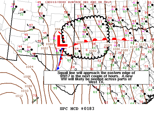
SUMMARY…Line of severe storms over eastern NM will continue to
track eastward into west TX. A new watch will likely be needed in
1-2 hours as storms approach the eastern edge of WW17.
DISCUSSION…Thunderstorms continue to intensify along a line from
near Carlsbad, NM northward into De Baca county NM. These storms
are moving eastward at 40+ knots and will move into west TX around
0130z. The environment ahead of the line is slowly destabilizing as
the warm front lifts northward across west TX. The 00z MAF sounding
shows less cap than forecast by recent model guidance. Given
current trends and recent CAM solutions, the threat of damaging wind
gusts and isolated tornadoes along the line will persist through the
evening. Therefore, a new watch is likely in the next 1-2 hours.


0 Comments