
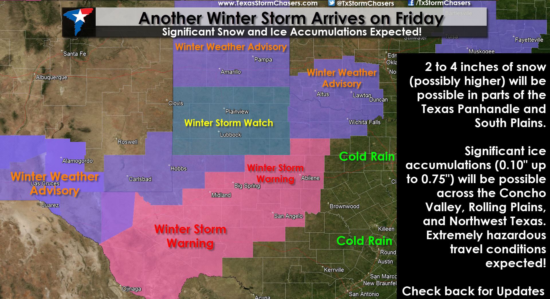
* WINTER STORM WARNING for the Permian Basin and Concho Valley until 12 PM Friday. Alpine, Pecos, Odessa, Midland, Big Spring, Snyder, Throckmorton, Abilene, and San Angelo are a few cities included. Travel remains hazardous across the warned area today as temperatures remain below freezing. Additional freezing rain will occur tonight which will deposit an additional 0.10″ to 0.25″ of ice on top of what has already fallen resulting in continued hazardous driving conditions.
* WINTER WEATHER ADVISORY for all of the Texas Panhandle and Northwest Texas from Friday through Saturday afternoon. Dalhart, Dumas, Spearman, Canadian, Amarillo, Pampa, Shamrock, Quanah, Vernon, Seymour, Wichita Falls, Archer City, and Henrietta are all cities included. Precipitation is expected to begin on Friday as the next piece of upper level energy enters the region. Snow totals of 2 to 4 inches will be possible in the Texas Panhandle with significant ice accumulations up to 0.50″ in Northwest Texas. Hazardous travel conditions will develop and travel will become difficult and dangerous.
* WINTER STORM WATCH for the South Plains and Rolling Plains from Friday Morning through Saturday morning. Muleshoe, Dimmitt, Tulia, Plainview, Lubbock, Brownfield, Post, Spur, Paducah, and Childress are cities included in the watch. Significant accumulations of snow and ice are possible during the second half of Friday into Saturday as our next winter storm pushes into the region. The overall temperature profile will determine exact precipitation types and accumulations. We’ll have time tonight to refine the forecast and nail down the accumulation forecast.
______________________________
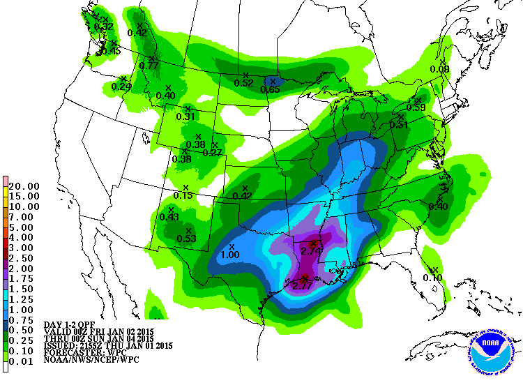
Confidence is how our next winter storm will play out remains low. This morning’s weather model guidance has come in with more moisture which raises the concern for significant accumulations of snow and ice across the Panhandle, South Plains, Rolling Plains, and Northwest Texas where temperatures will be below freezing. Temperatures in North and Central Texas and points east will be above freezing so we’re not worried about winter weather for the eastern half of Texas. It’s going to be a cold, wet day though with high chances for rain. Here’s the liquid rain forecast for through Saturday across Texas. Please note this graphic includes the liquid equivalent of winter precipitation that falls as well.
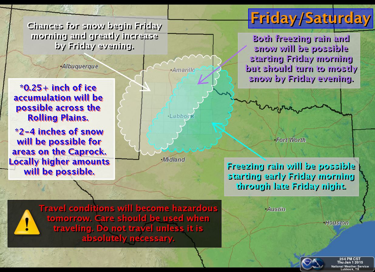
Since we’re still about 24-30 hours out from the upcoming winter storm we still have time to look at this evening’s weather model data and hopefully get a good consensus on where the heaviest snow and ice amounts will accumulate. Here are the latest forecasts from National Weather Service offices across the impacted areas. Please note the forecast will likely change including where/how much winter precipitation falls. Check back for forecast updates later tonight and on Friday.


0 Comments