
Oh no, it’s gonna snow! Alrighty, with that bit of hysteria out of the way let’s actually talk about today’s interesting weather forecast. To quote the forecast discussion from the National Weather Service in Houston yesterday afternoon…
Odds are, any precip that is generated evaporates/sublimates and nothing reaches the surface. This would be in line with what the HRRR and RAP suggest. Indeed, the general trend in the models is a drier one. Still…that dry air allows for a wet bulb profile that is entirely below zero…and just screams to me, “lots of people are gonna get cell phone video of about 10 sleet pellets pinging off tin roofs and cars”. So, in deference to the fact that if we get enough precip to evaporate and saturate a wet bulb profile, a few sleet pellets might just survive to the ground. Indeed, if we`re cold enough that ice crystals are generated, there`s an even smaller chance of a snowflake or two. I begrudgingly added these to the grids in the morning, on the off chance it happens.
That forecast tidbit applies to the Brazos Valley and Southeast Texas, although the layer of dry air in the atmosphere will be universal across much of the state tomorrow. So now that we’ve gone over the hysteria section and disgruntled section, we will finally go over what could unfold today. We’ll actually see a fairly widespread area of precipitation falling across South-Central Texas, the Hill Country, Central Texas, into North Texas at points this morning, afternoon, through mid-evening.
What the heck is wet-bulb cooling?
However, that dry airmass above the surface will result in most precipitation evaporating before reaching the ground. The wet-bulb process results when enough precipitation falls to raise moisture levels – while cooling temperatures. Think of it as when you get out of a pool on a summer afternoon. Even though temperatures could be in the 90s or 100s, you still feel a bit cool as the water evaporates off your body. That effect is exacerbated when coming out of a hot shower into a cool room. The same process occurs with precipitation, and in today’s case, could result in temperatures aloft falling below freezing from the cloud base all the way down to just above the surface.
The result? Yet another case of some sleet pellets and snow flurries while surface temperatures are a couple degrees above freezing. We’ve seen this unfold several times this winter thanks to dynamic cooling (the process in which a strong storm-system aloft cools the entire atmospheric column) with today’s effect being more wet-bulb driven (evaporating precipitation cooling the atmosphere, eventually leading to saturation and temperatures falling to wet-bulb). A majority of precipitation will evaporate, even when wet-bulb is reached and the atmosphere becomes more saturated.
A bit of everything possible today, but not very much of it
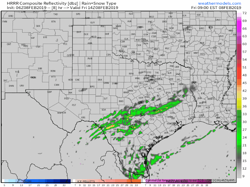
*SIMULATED* model radar this morning through the evening hours. Don’t place too much trust in the model’s precipitation type depiction, and use this as it is intended – a guideline.
The High-Resolution Rapid Refresh model seems to have a decent depiction of precipitation this morning through the evening hours. You can see we never really do see anything more than light precipitation across the aforementioned regions. It also keeps most precipitation predominantly rain with some mixing possible at times. Given the fact surface temperatures will be above freezing we’re not expecting accumulations and no travel issues.
There is a small chance that we could see a very localized band of heavier sleet/snow set-up over the eastern Hill Country and Central Texas this afternoon or this evening. This scenario could result in a very small area of minor accumulations that could make for some icy spots. However, any accumulations and limited travel impacts would be short-lived (as in hours). Sorry folks, no snowmen or other ‘snow’ creations today, except maybe a kid-sized snowcone.
Chilly tonight, but not as cold as this morning
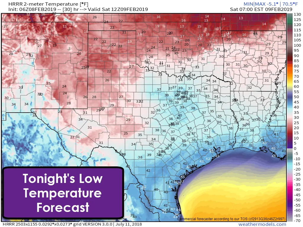
Low temperatures tonight will be warmer than this morning, but still in the chilly to the cold department. The freezing line will retreat farther to the west and north with wind chills not being as obnoxious. Overall, Saturday morning will be chilly, but not anything unusual for early February.
Saturday? Yeah, not an outside kind of day
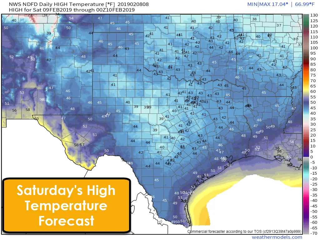
Widespread cloud cover will keep high temperatures in the below-average department on Saturday. High temperatures across Texas will be fairly uniform (for once) with mainly 40s. El Paso toward Alpine wants to be exceptions with the upper 50s for highs. Temperatures will be too warm to support winter precipitation.
Oh good! More rain chances… for days.
A brief lull in precipitation is expected this evening before we move on to our next precipitation event. This next event will be all rain as temperatures rise safely above freezing. Rain chances will increase on Saturday and especially Saturday Night across the eastern half of Texas. These rain chances will continue into Sunday, Monday, and Tuesday. Finally, we should start to see precipitation come to an end on Wednesday.
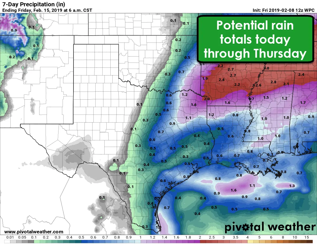
Rain totals from today through Wednesday are expected to be between one to two inches across Northeast Texas. Totals will be lighter and between one-half inch and one inch across the eastern half of North Texas (east of a Sherman to Dallas to Waco line) and across the Coastal Plains. The western half of Texas, generally west of Highway 281, should remain fairly dry for the next seven days. Projected rain totals are not high enough to raise any alarm bells in the flash flooding department. Severe thunderstorms are not expected at this time, nor is any more winter mischief.
Extended range temperature outlook
We’ll start the warming trend on Sunday as we see daily high temperatures start climbing back toward average and then eventually above-average. We may see another period of ‘spring’ after Monday and Tuesday before a strong storm system takes shape toward Thursday and Friday. We’re getting toward the time of year where we have to keep an eye on both winter and severe weather prospects.


0 Comments