
Fall is our secondary severe weather season in Texas as the jet stream dips farther south and we start to encounter airmass changes. That’ll pretty much sum up how tomorrow is going to place out in places like Kansas, the Oklahoma Panhandle, southward into the Texas Panhandle and northern sections of the South Plains and Rolling Plains. The fine folks over at the Storm Prediction Center have included all those regions in a severe weather risk zone for the late afternoon and evening hours tomorrow (Friday, October 6).
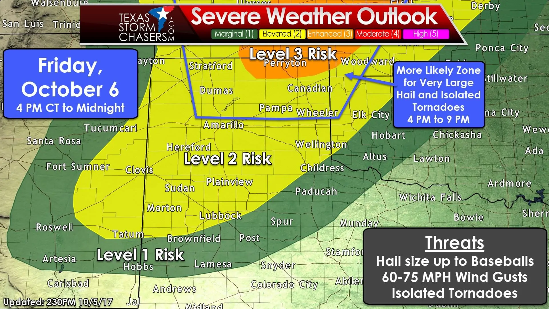
We have the standard level 2 risk zone encompassing all of the Texas Panhandle, the Caprock, extending southward into most of the South Plains and a sliver of the Rolling Plains. A level 1 risk zone – where isolated severe wind/hail will be possible – runs along and north of a line from Hobbs (NM) to Lamesa to Vernon. A level 3 risk for severe weather – an enhanced risk – does include the eastern Oklahoma Panhandle and extreme northeastern Texas Panhandle near Perryton. That increased risk zone essentially is where a higher frequency of severe weather occurrences is expected. Don’t pay too much attention to where that line is drawn today as we’ll likely see it refined in future outlooks on Friday. I have included a zone where I believe the highest relative risk for destructive hail and perhaps an isolated tornado or two may occur. That zone includes the northern/northeastern half of the Texas Panhandle. A severe thunderstorm is defined as one producing wind gusts over 58 MPH, hail of at least 1 inch in diameter (quarter size), and/or a tornado.
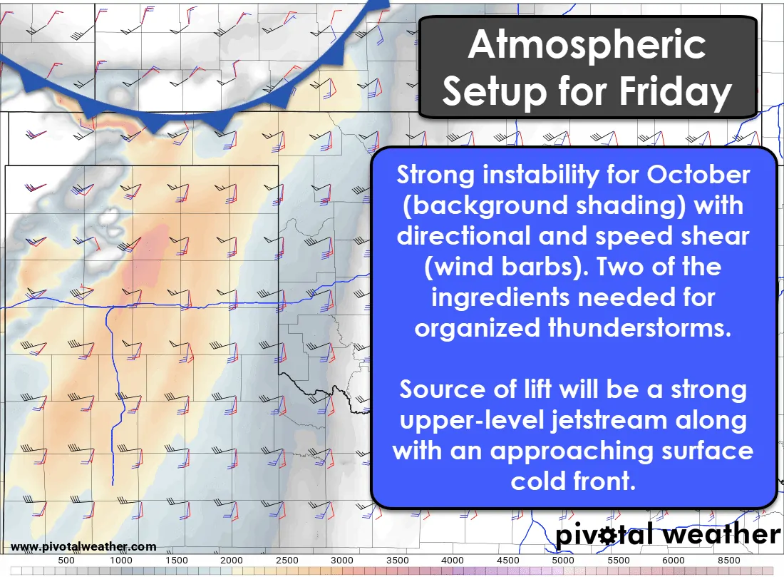
I’m not going to bore you with the meteorological aspects expected for tomorrow’s storm setup, but we’ll go over a few items real quick. Clearing skies across the Panhandle tomorrow should allow temperatures to rise into the 80s. Surface dewpoint values in the 60s – a way to measure moisture – will be supportive for organized thunderstorms. Both of those values will combine to help destabilize the atmosphere. If we do attain several hours of sunshine tomorrow across the Panhandle we’ll see the atmosphere become quite unstable for a fall severe weather event. Wind barbs on the graphic indicate wind direction and speeds at various levels in the atmosphere. You can see we’ve got winds at the surface coming out of the south/southeast (red barb) while winds in the middle levels of the atmosphere will be screaming at over 60 MPH out of the west. That is what we call wind shear and we’ll have plenty of it for tomorrow. That means instability, wind shear, and moisture values will support organized thunderstorms in general. Low-level wind shear will be on the weaker side during the afternoon but will increase toward sunset as winds just above the surface ramp up. That’s why the tornado threat for tomorrow currently looks low, but an isolated tornado will be possible.
The first thunderstorms of the day should fire up between 3 and 5 PM across western to central portions of the Texas Panhandle. By that point, storms will already be underway farther north into Kansas where the cold front will be located. The initial storms tomorrow afternoon in the Panhandle could be more isolated and discrete – supercellular in nature. The strongest supercells could produce some pretty big hail as those seasonably high instability values will support good hail growth. Not all storms tomorrow will produce very large hail, but I expect I’ll probably be under the one storm that does produce baseballs. As the cold front moves south and we get into the middle-evening hours’ thunderstorms should grow upscale into a squall line in the Panhandle. Additional thunderstorms will also be underway by the early evening hours across parts of West Texas. Once storms grow upscale into a squall line the threat for very large hail will decrease, but we may see more of a tendency for those straight-line wind gusts to approach 70 MPH. There will be a small window for a tornado threat in the northern/northeastern Texas Panhandle from about 5 PM to 9 PM tomorrow. We’d need to see all the ingredients come together just right, but a substantial tornado threat is not expected at this time. A majority of the team will be chasing in the Panhandle tomorrow, so be sure to follow our social media feeds for chase updates.


0 Comments