
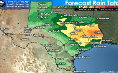
We continue to monitor the storm situation in the Texas panhandle this evening. Scattered supercell thunderstorms have developed over the past few hours. So far, no confirmed reports of tornadoes, but the storm currently northeast of Matador has the best potential we’ve seen so far. Winds in excess of 70mph and hail up to 2 inches is possible with these storms as they continue to move northeast this evening. A Tornado Watch remains in effect for the southern Texas panhandle and rolling plains of west central Texas until 11pm. A Severe Thunderstorm Watch is also in effect for much of the Texas panhandle until 11pm as well. Not everyone will see severe weather as these storms are widely scattered, but if you’re under one of these supercells, they pack a punch.

Further south across central Texas, we will be monitoring for scattered storm development later this evening and into the early overnight hours. The storms across the panhandle will not impact north Texas this evening, but the development anticipated across central Texas later this evening will move up into north Texas overnight into an atmosphere that will become increasingly unstable through the early morning hours. Large hail will be the main threat overnight mainly north of the I-20 corridor towards the Red River counties.

0 Comments