
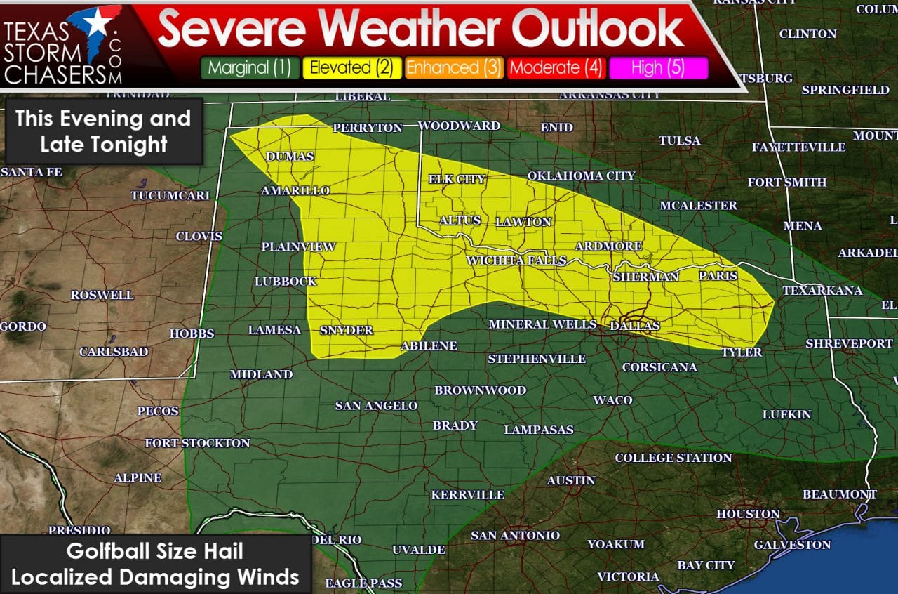
There will be two potential regions of thunderstorm potential through the morning hours Friday. The first region is across the Texas Panhandle, South Plains, and West-Central Texas late this afternoon and early this evening. A surface low pressure taking shape in eastern New Mexico will cause favorable wind shear for organized thunderstorms. At the same time marginal moisture levels will be on the increase across the aforementioned regions throughout the day. The quality of moisture looks limited which will likely keep storms that develop this afternoon high-based. I mention high-based storms because they typically have only a very low risk of producing tornadoes. The overall tornado risk today is very low, fortunately. The primary severe weather threat with the strongest storms this afternoon and early evening will be large hail up to the size of golfballs and localized damaging wind gusts over 65 MPH. As storms move northeast they should begin to weaken by the early evening hours as they move into a more stable environment. That leads us into the second region of potential thunderstorm activity. A warm front will be moving north tonight. As the warm front moves north moisture levels will quickly increase and the atmosphere will become more stable. Lift associated with the warm front will help generate scattered thunderstorms overnight across Northwest Texas, Texoma, and portions of North Texas. Right now the highest chance for a few severe storms with hail will be within 50 to 70 miles of the Red River. The strongest storms will be elevated (rooted above the cap) with a threat of hail up to the size of ping-pong balls. Otherwise storms will produce frequent cloud to ground lightning and brief heavy rain. Don’t be surprised if you get woken up by a boomer overnight if you live in the aforementioned regions.
Friday is setting up to be a potentially busy severe weather day. The warm front that will be moving north tonight should push north of Interstate 40 in Oklahoma by Friday afternoon. At the same time a dryline will surge east into the Big Country, Northwest Texas, and Western Oklahoma. The surface low in New Mexico today will be located near Amarillo by the afternoon hours tomorrow. Wind shear values will support organized thunderstorms while the atmosphere – assuming we don’t have widespread clouds/rain hold around – should become very unstable. If we have widespread rain continue near/east of the dryline the atmosphere will be less unstable and the threat for significant severe weather will be lower.
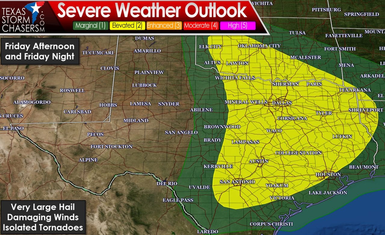
The Storm Prediction Center has highlighted a category 2 severe weather risk for North Texas, Central Texas, South-Central Texas, the Brazos Valley, East Texas, and Northeast Texas. Isolated to widely-spaced supercell thunderstorms may develop after 3 PM just east of the dryline. The strongest storms would become intense with very large hail larger than the size of baseballs, localized damaging wind gusts over 70 MPH, and a threat for isolated tornadoes. Those storms would move east/northeast through the early evening hours. As a cool front overtakes the dryline by early evening more widespread thunderstorm development should occur as the dryline ‘unzips’ from north to south. Another squall line – similar to the one on Tuesday – would move east into the late night and early morning hours on Saturday. That squall line would be capable of producing damaging straight-line winds, hail up to the size of ping-pong balls, and brief tornadoes. There are still uncertainties which is why we’re looking at a broad category 2 risk area. Once confidence increases on where the highest coverage of severe weather will occur there may be upgrades in the risk zone. MayFest also starts up tomorrow and something always seems to happen during that period soooooooooo we’ll be watching it closely.
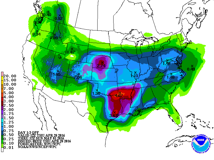
Widespread precipitation starting Friday evening through Saturday could bring one to four inches of rain to locations along and east of Interstate 35 from the Red River through the Brazos Valley. Soils remain saturated and some flash flooding is anticipated. If we can get all that rain to fall over a period of a day we shouldn’t see too much flash flooding. If we have all that rain fall in the period of a few hours I do expect flash flood warnings will light up East Texas. Additional river rises are anticipated although the extent of which will depend on how much rain falls upstream. This shouldn’t be a major flood event but after last week we’ll be watching it closely.


0 Comments