
The Storm Prediction Center has upgraded all of Northwest Texas, Texoma, the eastern Big Country, North Texas, and portions of Central Texas to a category 4 (moderate) risk of severe weather for this afternoon and tonight. This upgrade is due to increased confidence in multiple severe thunderstorms capable of producing very large hail and damaging winds. Tornadoes are also a threat – especially in the enhanced and moderate risk zones. The remainder of the severe weather outlook remains unchanged. Please see our full thoughts below for timing and threat details.
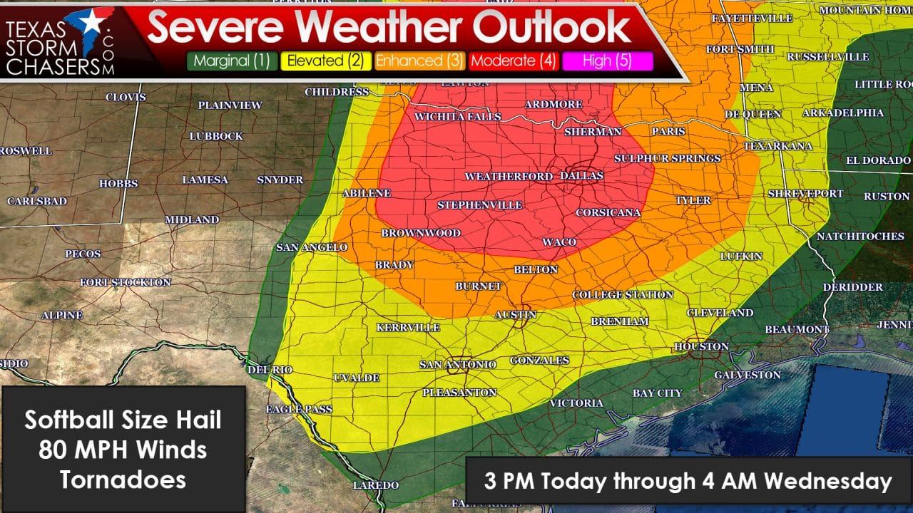
Isolated supercell development will likely occur after 3 PM across the Big Country into western Oklahoma. These initial storms will rapidly intensify and become severe. All modes of severe weather will be possible with the strongest storms. Giant hail up to the size of softballs, damaging wind gusts up to 80 MPH, and tornadoes will be possible. An isolated strong tornado is not out of the question with discrete supercells west of I-35 this afternoon and evening. I expect we’ll see a number of storms go up between 3 and 6 PM across Northwest Texas into the Big Country. All these storms will be moving northeast at 25-40 MPH. The more intense supercells may deviate to the right and move more east/northeast. Not all these storms will be capable of producing tornadoes or softball size hail. The strongest storms could be intense and capable of producing significant severe weather. By early evening we may have a combination of discrete and semi-discrete supercells moving into western North Texas and Texoma. By this point the threat for straight-line winds up to 80 MPH may be on the increase. Destructive hail and tornadoes will likely be a continuing threat. A few hours after sunset I expect the storms will have formed into a squall line that will be marching east into North Texas. The strongest storms in the line will likely be severe with destructive winds up to 80 MPH, baseball size hail, and a threat for brief tornadoes. Any supercell that forms ahead of this squall line will have a tornado threat – although this is conditional on storms actually being ahead of the line. Current timing projections have the squall line moving into the D/FW Metroplex between 9 PM and 1 AM – and some storms will be severe. By midnight the squall line will likely be in or just east of D/FW and extending southeast into the southern Big Country and Hill Country. I wouldn’t be surprised to see much of the line severe-warned with a threat of damaging straight line winds and large hail. Isolated tornadoes will continue to be threat tonight – especially in embedded supercell structures in the squall line. I do not expect a tornado outbreak today (that is numerous strong tornadoes). However I do expect we will have at least a few tornadoes with the initial discrete storms this afternoon and even brief tornadoes embedded in the squall line tonight. Very large hail will be a significant concern along with damaging wind gusts tonight with the squall line. Have multiple ways to receive severe weather warnings tonight.


0 Comments