
The radar is lit up like a Christmas tree this morning across the Hill Country into East Texas. Two separate areas of thunderstorms are making their way east/southeast. We’re not dealing with any severe weather this morning but it’ll certainly make for a wet go at it. The rain/storms are expected to move into the Houston area in the next hour or two. Some localized flooding may occur but I’m not expecting a resurgence of significant flooding problems today. A second round of storms will move into the Austin and San Antonio metros in the next hour. The strongest storms will produce frequent lightning, small hail, and localized 50 MPH wind gusts. Localized flooding can’t be ruled out – especially in areas that are saturated from heavy rains earlier this week.
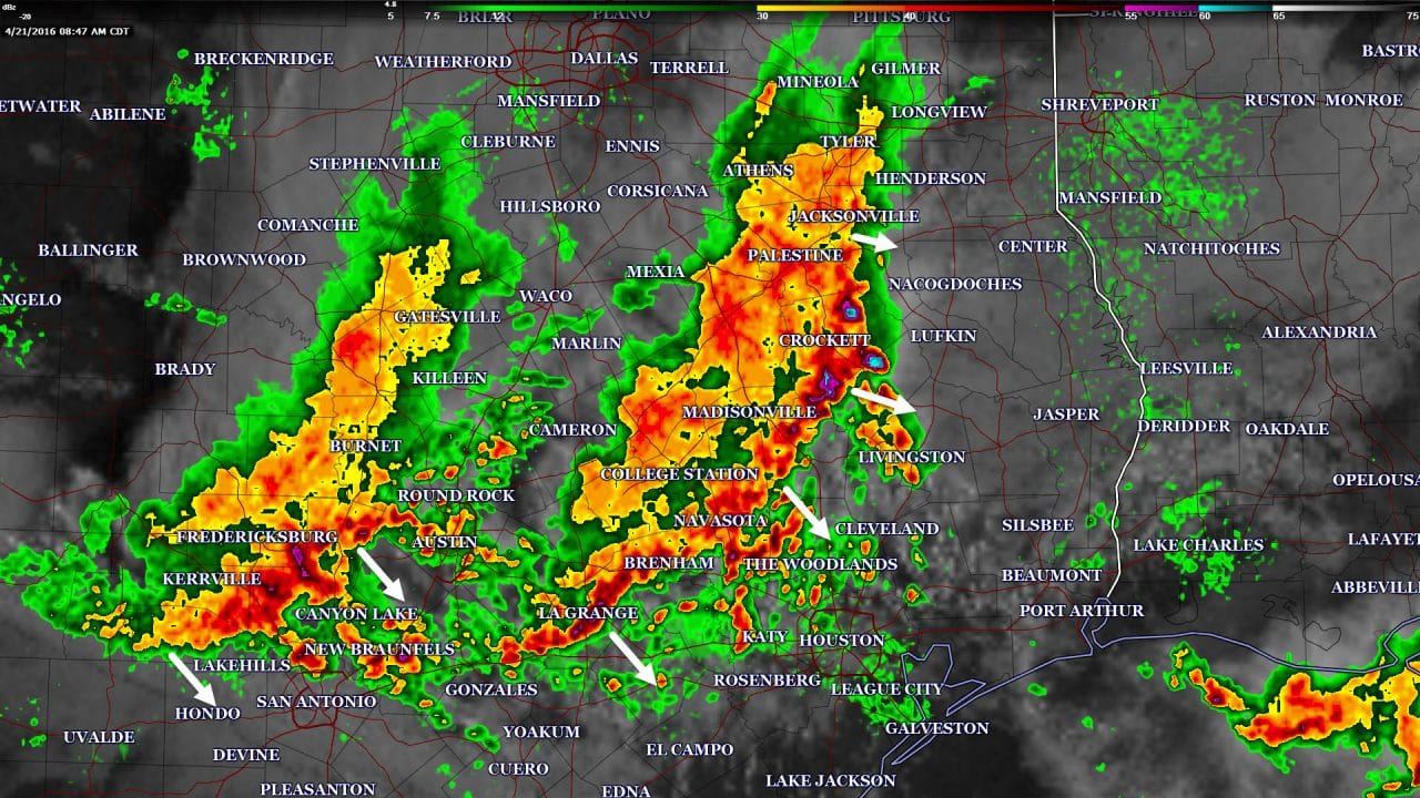
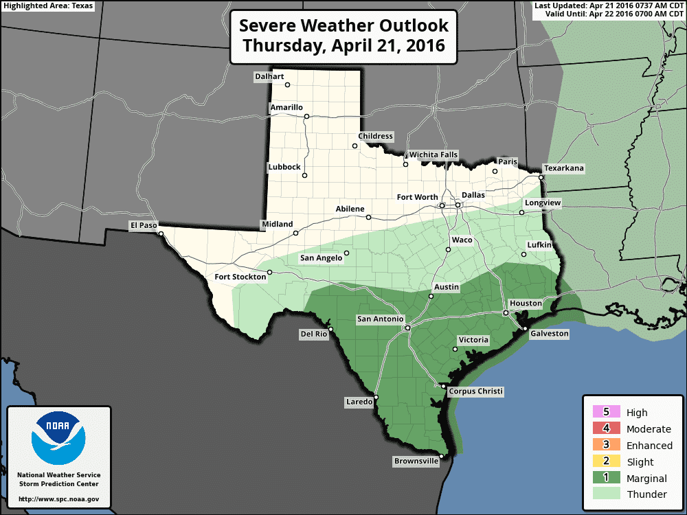
Depending on how quickly things can clear out we may see additional isolated storms fire up later this afternoon. The best chance of new convective development will be across South Texas and the Coastal Plains. I do expect thunderstorms will develop in the higher terrain of Mexico by the mid-afternoon hours. Atmospheric conditions will favor splitting supercells. The right-moving supercells will move due south and likely remain in Mexico. The left-splitting storms could move due easterly and possibly move into Texas by early evening. A couple storms capable of producing large hail and localized damaging winds will be possible. The Storm Prediction Center does have a marginal severe weather risk highlighted from the Rio Grande Valley northeastward across the Texas Coast up into Southeast Texas to account for the isolated severe weather threat.
The good news is Friday and Saturday are both going to be quiet in terms of the weather. This upcoming week is looking very active in the storm department, however. The Storm Prediction Center has highlighted the potential for an isolated severe weather threat late Saturday afternoon and evening across the Texas Panhandle. If storms can develop a few may be severe with a hail threat. We may see a few showers/storms on Sunday but this upcoming Tuesday and Thursday could both be active with severe weather risks. At this juncture we’re simply too far out to tell how significant the severe weather threats may become. There are factors such as cap strength and where the strongest upper level lift will be located each day. The potential for significant severe weather is possible on Tuesday across Kansas and Oklahoma where a regional severe weather outbreak is possible with tornadoes. That potential is less certain in North Texas as there are signs the cap may keep thunderstorms from developing.
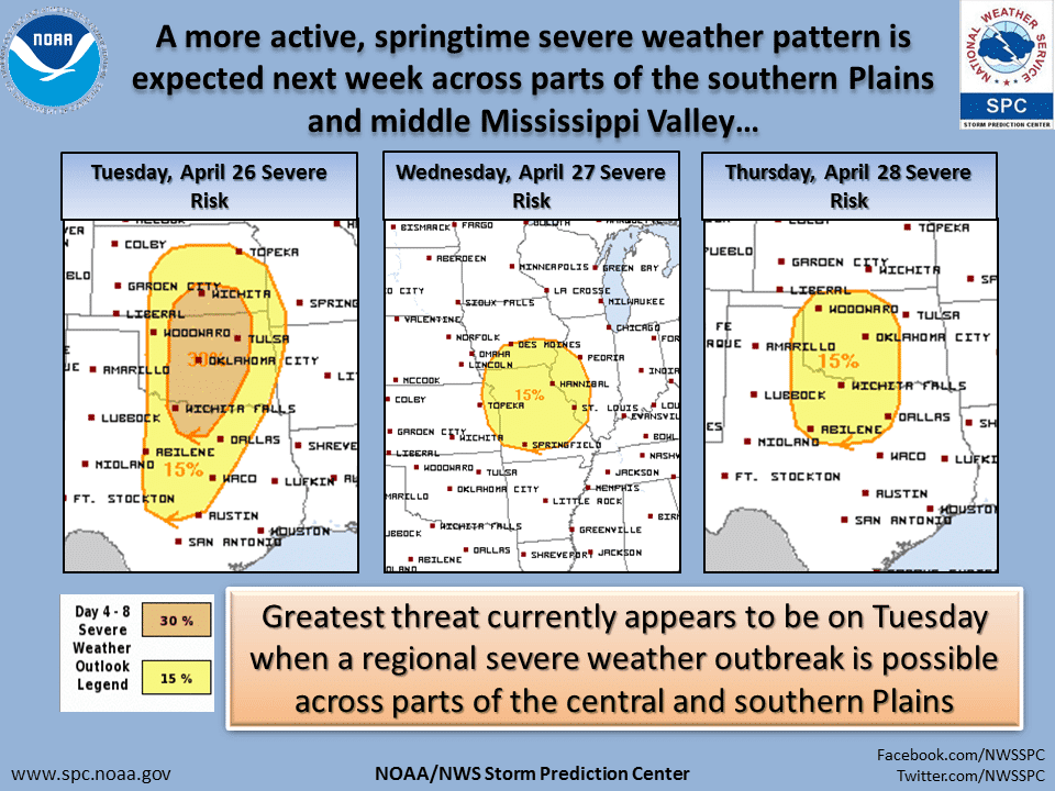
If we do have storms develop off the dryline on Tuesday they would likely be severe and capable of producing all modes of severe weather. Thursday could also be active in the severe weather department in Northwest and North Texas. Understand that this is spring in Texas. We deal with severe weather risks. Risks that look significant 5-7 days out can change and poop out as time gets closer. The synoptic upper air pattern next week is one that has produced significant outbreaks in the Plains – but that doesn’t mean the threat will extend south into Texas. Other weather organizations will likely be hyping next week’s storm potential to get attention. I encourage you to ignore the hype and just keep tuned to a trusted weather source for information. Could next week feature significant severe weather in Texas? Yes. Is it a guarantee? Absolutely not. We’ll keep you updated on the latest forecasts as we get into the weekend.


0 Comments