
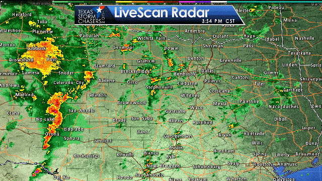
- A building line of storms continues to make eastward progress in Southwest Texas, the Concho Valley, and the Big County. Essentially the line is about 15 to 20 miles west of a line extending from Del Rio to Sonora to San Angelo to Robert Lee. This line has shown increasing organization over the last 30 minutes and I would expect some of the storms to become severe over the next hour.
- At the same time we’ve seen an increase in elevated thunderstorms across western North Texas from Hamilton to Stephenville to Mineral Wells to Jacksboro. These elevated storms could produce heavy rain and small hail, but shouldn’t become severe.
- The primary severe weather threat this evening should originate from the squall line. The strongest sections of the squall line could produce damaging straight-line wind gusts of 55 to 70 MPH. Brief tornadoes and hail are also possible. The severe weather threat will be highest this evening along and west of Interstate 35/35E. Once the squall line gets near Interstate 35 it’ll start outrunning the upper level energy and should weaken as it trends toward Northeast Texas and East Texas.
- A secondary concern is the potential for discrete storm development in the open warm sector in North-Central Texas this evening. Low-level wind shear is quite strong, but the atmosphere is only modestly unstable for surface-based storms. It is not out of the question that we see a low-end tornado threat develop with isolated storms ahead of the squall line this evening. We’ll be monitoring for that potential, but the squall line is the likely culprit to produce some wind damage into the evening hours.
- An additional severe weather watch will probably be issued for portions of North and Central Texas as the squall line approaches later this evening.

0 Comments