Meteorological spring starts today as March rolls in with… you guessed it! Warm weather. Although we will have a cool front moving south through the state today. Patchy fog is occurring across the southeast half of Texas. It doesn’t seem to be nearly as dense as we saw on Monday. Any fog should burn off by mid-morning.
High temperatures this afternoon will depend on which side of a cool front you end up on today. The Rio Grande Valley and Deep South Texas will be toasting with upper 80s into the lower 90s. Folks to the north in the Panhandle will be on the cooler side of the spectrum with highs in the upper 50s today. Between both of those regions we will have high temperatures in the 60s and 70s today. The cool front moves south through Central Texas early this afternoon. We’ll see temperatures north of the front drop into the 60s with middle 70s south of the front. The ‘cooler’ side of the front will cause temperatures to drop back towards average.
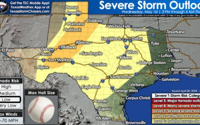
If you visited us yesterday we were chatting about the potential of a few stronger storms along the front today. The cap continues to look strong and most ‘lift’ will remain off to our east. Rain chances have continued to diminish and I expect a mostly dry cold front passage today. A few showers will be possible across Northeast Texas and East Texas today. Severe weather is not expected. In fact we may not even get bonafide thunderstorms. Skies will be mostly cloudy south of the front. As the front progresses south this morning and afternoon skies will clear from north to south. You can’t blame the weather for not getting out to vote today.
Low temperatures by Wednesday morning will be plenty warm in the Rio Grande Valley. The cool front will become stationary in Deep South Texas tonight. Lows south of the front will only drop into the middle 60s with fog a distinct possibility. Drier air north of the cool front will allow temperatures to fall back into the 30s and 40s tonight. Clear skies and light winds will result in ample radiational cooling. Don’t be surprised if you see local temperatures vary over a short distance. Those drastic temperature variations would be mainly based on urban-centers and topographical features.
A series of powerful upper level storm systems may impact the southern United States next week. After two months of relatively quiet weather it looks like our weather is about to become more active.


0 Comments