

The atmosphere will undergo a state of change today ahead of an approaching cold front late tonight into Tuesday. Pockets of fog are proving to be a problem across Northeast Texas, East Texas, into Central Texas and South Texas. Some fog is causing visibility reductions below one mile this morning. As temperatures start to warm after sunrise the fog should begin to lift. Most fog should be gone by 10 AM CT.

Southerly winds will help with moisture advection today. Moisture levels, measured by the dewpoint temperature, will continue rising into the 50s and 60s across the eastern half of Texas by tonight. The increasing moisture will result in partly sunny to mostly cloudy skies in those areas. The western half of Texas will see mostly sunny to partly cloudy skies. Even with clouds temperatures will still warm into at least the 70s across all of the state this afternoon. The Permian Basin and South Texas look to be warmest with highs in the middle 80s.

Gusty southwest winds, warm temperatures, and low humidity values in the afternoon will create very high fire danger across Far West Texas, the Permian Basin, South/Rolling Plains, and the Texas Panhandle. The same threat will exist on Tuesday except it will spread east into Northwest Texas, the Big Country, and Concho Valley.

Temperatures tonight will be warm across the eastern half of Texas. Fog will be a possibility along with southerly winds. This is where moisture values will continue rising with dewpoint temperatures expecting to rise into the 50s to lower 60s. It’ll feel noticeably humid by morning. Drier air across Western Texas will allow temperatures to fall back into the upper 30s to upper 40s.

Meteorological spring begins tomorrow and Mother Nature seems to have her clock well tuned. An elevated risk of severe weather, level 2 out of 5, exists tonight across Central and Eastern Oklahoma. A marginal risk of severe weather, level 1 out of 5, includes the eastern Texas Panhandle and the Red River into Texoma. Isolated to scattered thunderstorms are expected to develop by mid-evening on the Texas Panhandle/Oklahoma border.


Those storms will move east towards Oklahoma City by midnight. Afterwards they may begin to turn more southeasterly towards Southeast Oklahoma. Its possible a second area of thunderstorms may develop across Southern Oklahoma this evening. Should those storms develop they could ride east just north of the Red River. In all likelihood thunderstorm activity will remain north of the Red River this evening and for much of the night.

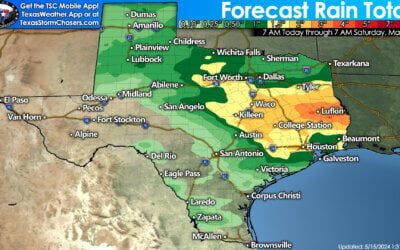
A cold front will move south across Texas on Tuesday. Behind the front temperatures will be about 10 to 15 degrees cooler compared to today. Much drier air will also arrive behind the front with dewpoint temperatures falling back into the 20s and 30s. There is a possibility of a few thunderstorms on the leading edge of the front across North and Northeast Texas on Tuesday morning. These storms, should they develop, could become strong with some hail possible. Its not entirely out of the question that we see a broken line of storms fire along the front all the way into Southeast Texas on Tuesday.

If that occurs a few of the storms may become strong with a hail threat. By far it appears a majority of folks will stay dry tomorrow. An updated severe weather outlook will be issued just before noon. We’ll share it along with any forecast adjustements during the lunch hour. The highest threat for thunderstorms and possible severe weather will be east/northeast of Texas.
0 Comments