
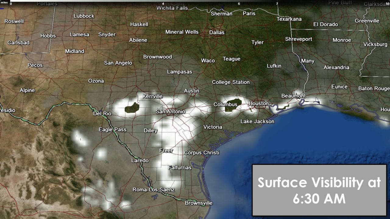
Starting out this morning we’ll be dealing with fog (again) along the lower and middle Texas coast. Some of the fog has made it inland into the Coastal Plains and Deep South Texas. Like the past couple of days I expect fog will mostly dissipate after 9 AM. Until then give yourself a little extra room on the road and don’t use your high-beam headlamps. You can expect much of the same for Friday morning.

Strong south to southwest winds will cause temperatures to soar later this morning. By this afternoon it will be very right to downright hot. Downslope winds will allow temperatures to soar into the middle and upper 80s across the Texas Panhandle, South Plains, Rolling Plains, Northwest Texas, Big Country, and the Permian Basin. The lower elevations out in the Permian Basin could reach 90 degrees this afternoon. The Rio Grande Valley, Deep South Texas, and South-Central Texas will also warm into the middle 80s this afternoon. Most of the Hill Country, Central Texas, North Texas, and Southeast Texas will top out in the upper 70s to lower 80s this afternoon. Finally folks in Northeast Texas and East Texas will top out in the middle to upper 70s this afternoon. We do note a wind advisory is in place for North-Central Texas today with winds gusting over 35 MPH out of the south. It seriously will feel like a late-April day.
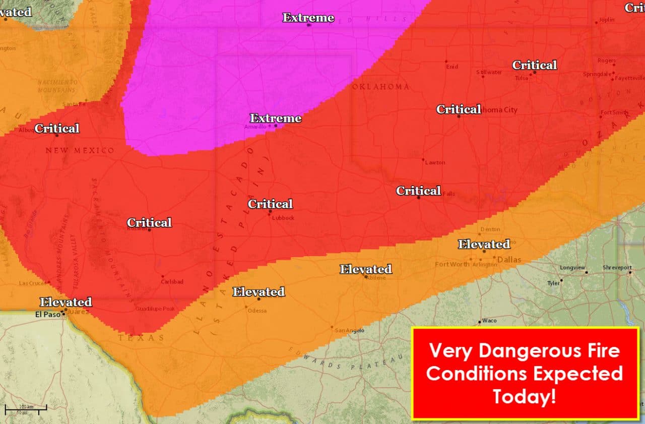
A very dangerous fire weather day is shaping up for the Texas Panhandle. The fire weather folks have issued an extremely critical risk for wildfires across the northwest half of the Texas Panhandle. There we expect relative humidity values to plummet to near 5 percent by early afternoon. Winds out of the southwest could gust up to 25-30 MPH and temperatures will soar to record values. Surface fuels are abundant and very dry as noted by increasing ERC (Energy Release Component) values. Critical fire weather conditions will exist across the South Plains, Rolling Plains, Big Country, and Northwest Texas this afternoon. Relative humidity values in those regions will drop to 10 to 25 percent. Temperatures will be in the 80s and winds will be gusting out of the south around 20-35 MPH. Surface fuels are very dry and conducive for fire growth. If a fire develops it will have a high chance of growing explosively.
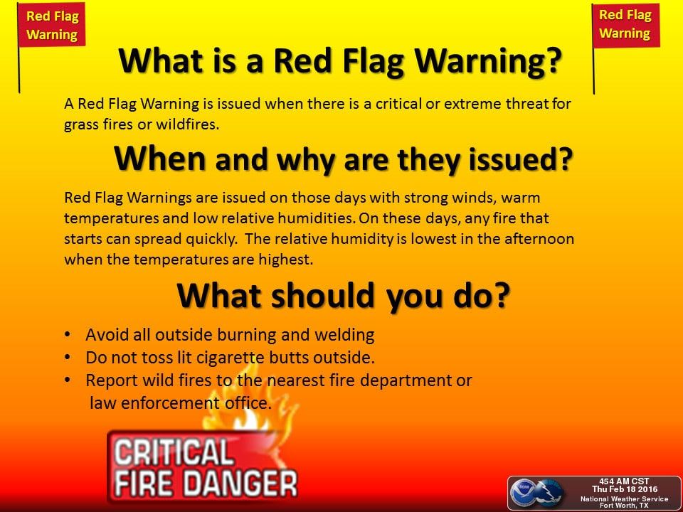
Situational awareness must be maintained by residents in locations prone to wildland fires. If you spot smoke or a fire heading toward your location you must be ready to evacuate quickly. Conditions today are quite favorable for large wildfires in the northwest half of Texas. I encourage folks to limit outdoor use of welding equipment today due to the gusty winds.

Temperatures tonight will be warm across the state. They’ll still drop off 25-35 degrees compared to this afternoon. Tonight’s lows will be in the upper 50s to low 60s across North Texas, East Texas, Central Texas, Southeast Texas, the Brazos Valley, South Texas, the Coastal Plains, and the Rio Grande Valley. 50s are expected across Northwest Texas, the Big Country, the Concho Valley, Hill Country, and Permian Basin. 40s will be common by Friday morning across the Panhandle, West-Central Texas, and Far West Texas. I wouldn’t be surprised to see pockets of fog develops where temperatures are closer to 60 degrees by morning. Fire danger will be lower on Friday thanks to increasing moisture values. Above-average temperatures shall remain through Saturday.


0 Comments