
Dry weather with above-average temperatures will continue for the remainder of the work week. The storm system that brought rain to Northeast Texas on Monday is now bringing tornadoes to Florida this morning. A probable tornado occurred within the past 30 minutes in western Broward County in Southeast Florida. That tornado was within a few miles of the Fort Lauderdale Terminal Doppler Weather Radar. With radar scans every one minute it was fascinating to watch the progression of the circulation.
FLL TDWR velocity data showing a tornadic circulation in Broward County, FL. #flwx pic.twitter.com/BbNhMzxHbQ
— Texas Storm Chasers (@TxStormChasers) February 16, 2016
Impressive radar data of a tornado in Broward County, FL from the FLL TDWR. #flwx pic.twitter.com/MyNIlNRFGz
— Texas Storm Chasers (@TxStormChasers) February 16, 2016
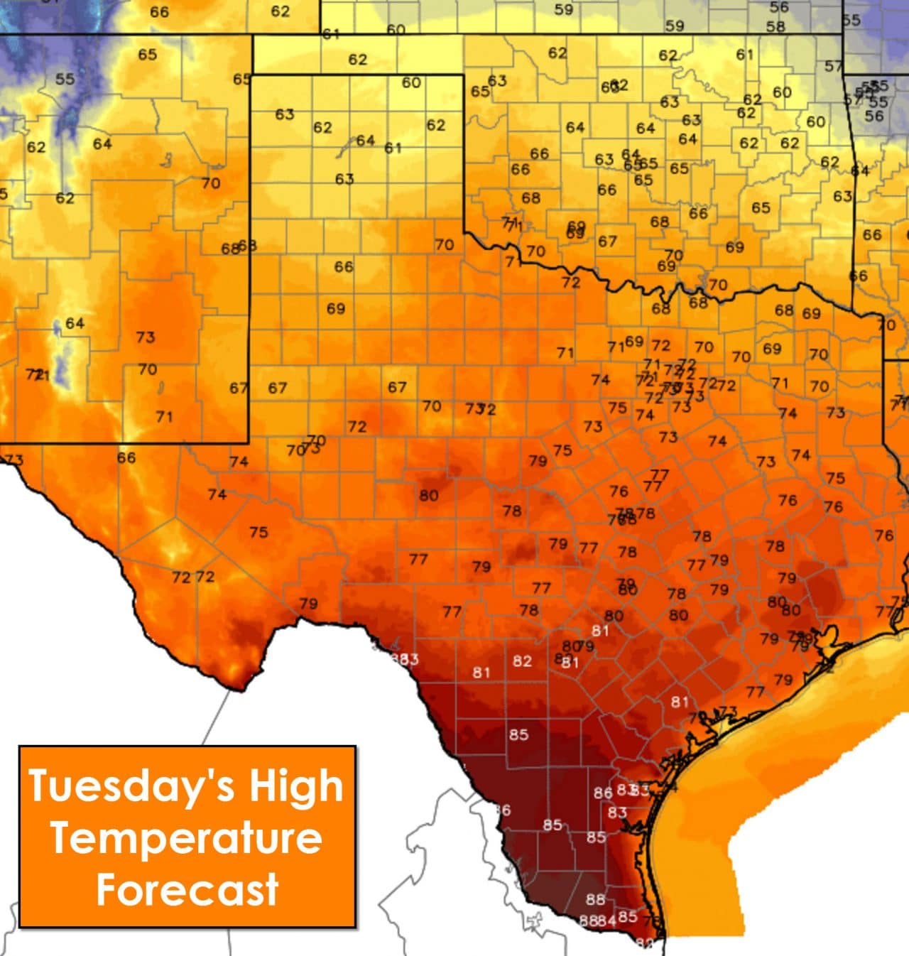
Mostly clear skies will continue for the next couple of days. The afternoons will feature above-average temperatures with record high temperatures expected for some on Thursday. For this afternoon temperatures will range from the lower 60s in the Texas Panhandle up into the 80s in South and Southeast Texas. Austin, San Antonio, Houston, Corpus Christi, and McAllen are all forecast to top out in the 80s this afternoon. One could easily assume this was an April day if not for the calendar.

Temperatures at night will still cool off enough for you to need a sweater. For tonight into Wednesday morning we expect temperatures to range from the middle 30s to the upper 40s. South Texas and the Rio Grande Valley will drop off into the 50s to right around 60 degrees. Previous winters have shown we could easily have much worse weather conditions.

Wednesday will be warmer yet with high temperatures ranging from 70 degrees in Northeast Texas into the middle 80s across the Permian Basin, Big Country, Concho Valley, South Texas, and the Rio Grande Valley. Relative humidity values will drop below 30 percent in the afternoon. The saving grace from critical fire danger on Wednesday will be winds remaining under 20 MPH. As any firefighter will tell you the grasses are dry and you can still get wildfires without a wind component.
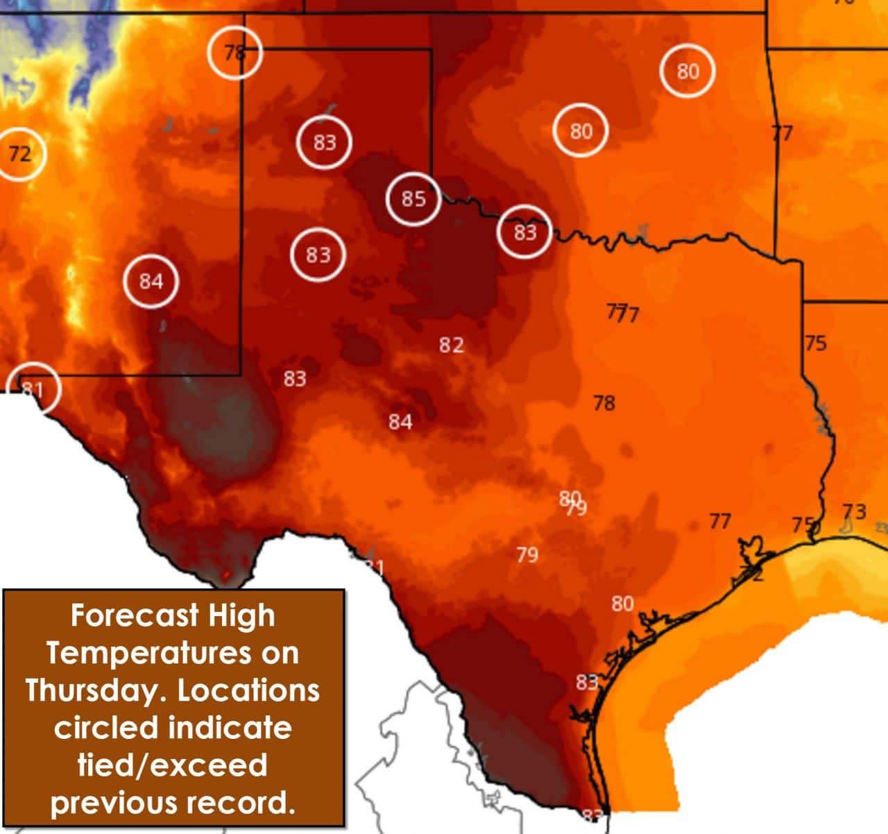
Thursday has the potential to be a problematic day with very critical fire danger possible in the Texas Panhandle. High temperatures on Thursday are forecast to reach or exceed previous record high temperatures with middle 80s expected in the Texas Panhandle, South Plains, and Northwest Texas. Parts of the Permian Basin could approach 90 degrees along with Deep South Texas. At the same time west winds will gust up to 30 MPH across the Panhandle into West Texas. Relative humidity values could plummet as low as 5 percent. All those factors indicate the potential for a significant fire weather event on Thursday. It takes a spark to create a wildfire. Lets make sure we don’t let things get that far on Thursday. Temperatures will be comparatively lower with upper 70s across North Texas, East Texas, Southeast Texas, and Central Texas on Thursday. Still well above average temperature-wise but not approaching record values.

0 Comments