Good morning Texas and whoever else might be visiting us this morning. Congratulations on surviving the work-week and welcome to Friday. I realize some of you might not have the traditional work schedule but look on the bright side. At least traffic isn’t nearly as bad on the weekend. I’m in Austin this weekend for a weather conference and had the ‘pleasure’ of driving in their rush hour last night. It goes without saying I don’t wish that on anyone. This isn’t a traffic blog so lets get on to the weather forecast.
This Morning
Temperatures this morning are quite cold again across Texas. The good news is we’ll warm up quite efficiently after sunrise and into the afternoon hours. Temperatures will peak near average for February 5. It may not be in the 70s but it certainly could be much colder. Five years ago I was covering the second round of winter weather in the D/FW Metroplex with the super bowl in town. With wind chills below zero I think we can all be thankful with today’s weather.
This afternoon and evening
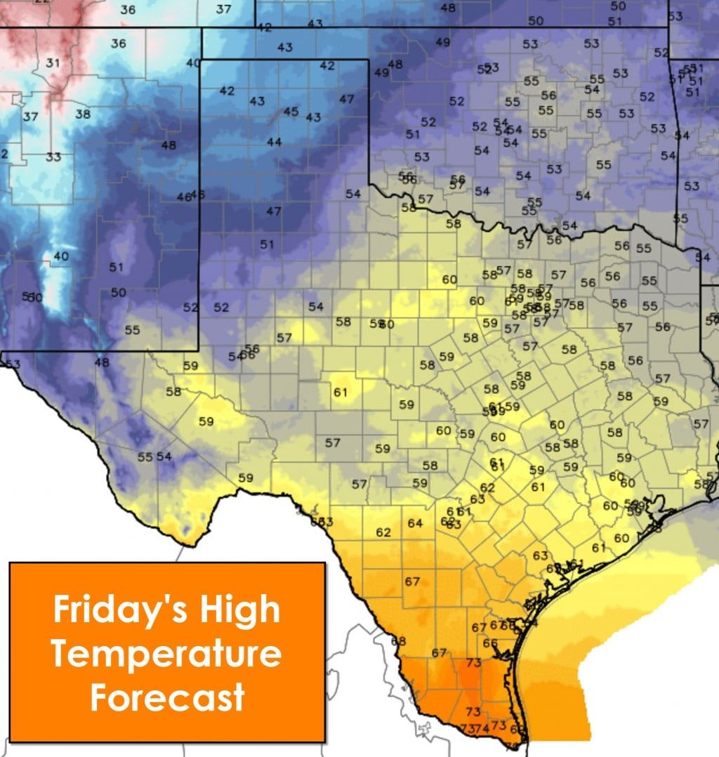
High temperatures this afternoon will actually peak in the low 70s across the Rio Grande Valley. 60s are expected across South-Central Texas and the Coastal Plains. Upper 50s to right around 60 degrees is the forecast across the Permian Basin, Big Country, Concho Valley, North Texas, Central Texas, the Brazos Valley, and Southeast Texas. As usual the coolest readings in the state will be across the South/Rolling Plains and Texas Panhandle where the peak afternoon temperatures will be in the 40s. Clouds will be on the increase by late afternoon across the Panhandle and West Texas. Those clouds are due to an upper level disturbance moving eastward. By this evening those clouds will move into locations east of Northwest Texas, the Big Country, Concho Valley, and Hill Country.
Light rain chances possible tonight and the first half of Saturday
A few sprinkles or very light showers will be possible tonight and on Saturday east of Northwest Texas, the Big Country, Concho Valley, and Hill Country. North Texas, Central Texas, Northeast Texas, and East Texas stand the best chance of getting a few sprinkles tonight and on parts of Saturday. Understand that moisture levels are quite low and thus any rain that reaches the ground will be light. Any showers won’t sit on any place long so a washout is not expected. Limited moisture levels mean no thunderstorms are forecast and neither is any severe weather or flooding.
Tonight into Saturday Morning
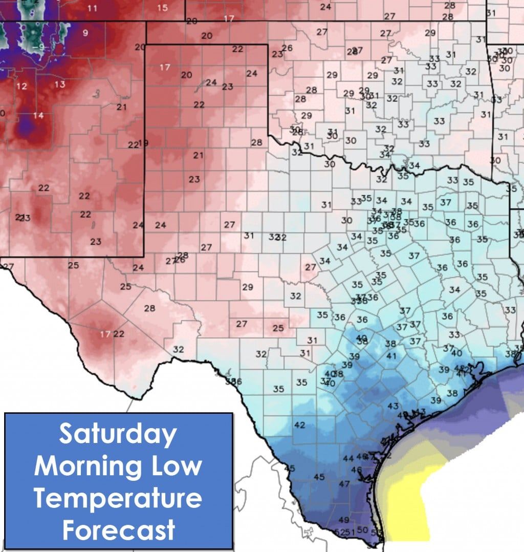
Low temperatures by Saturday morning be cold once again with 20s across the Texas Panhandle, South/Rolling Plains, Permian Basin, COncho Valley, and Far West Texas. Western sections of the Panhandle will likely fall off into the 10s. 30s are expected across Northwest Texas, North Texas, Northeast Texas, East Texas, Southeast Texas, Central Texas, and the Brazos Valley. 40s will be common on Saturday morning across South Texas and the Rio Grande Valley.
Warming up this weekend
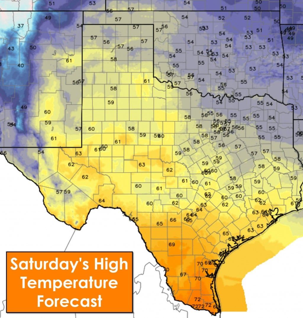
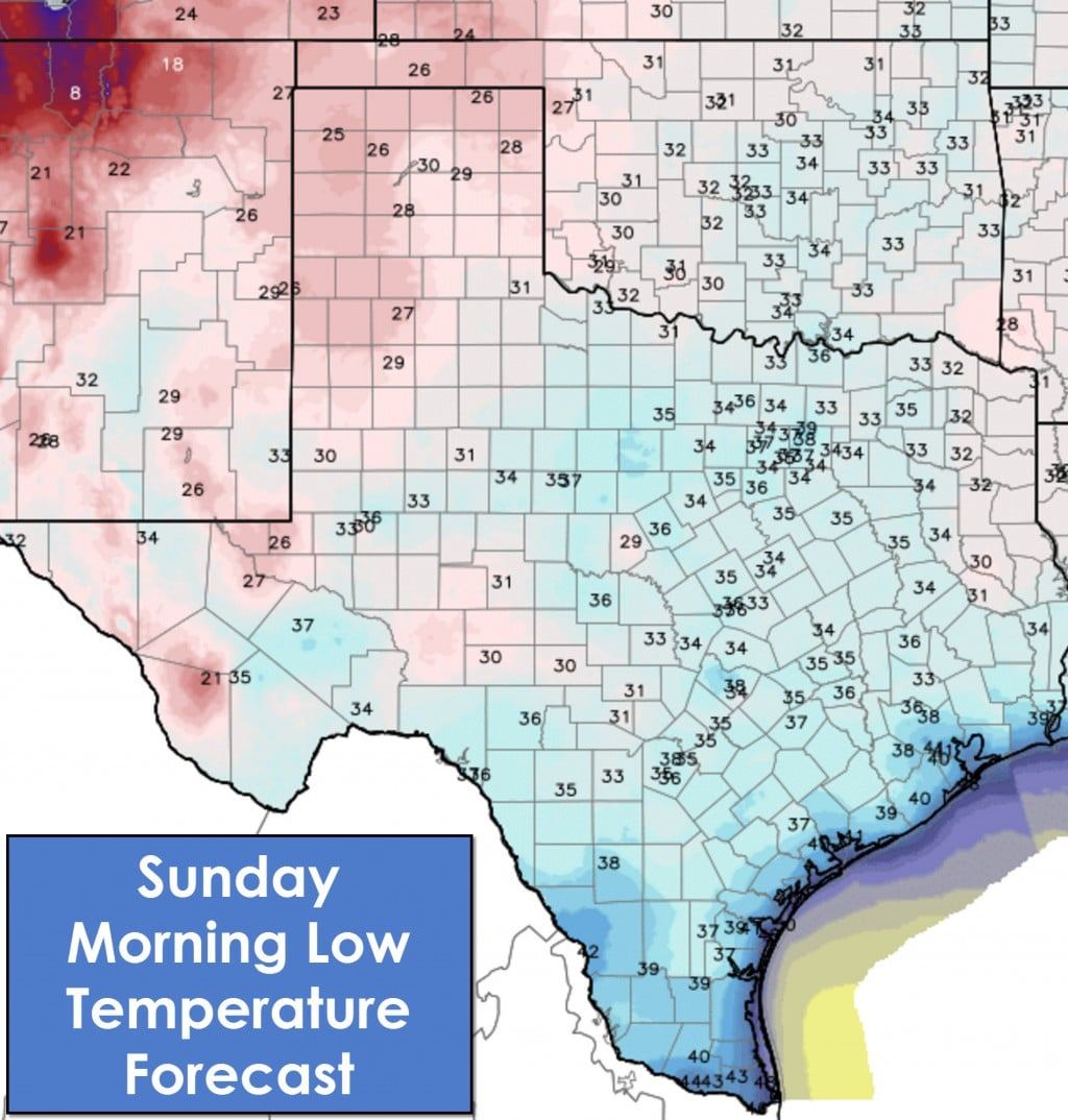
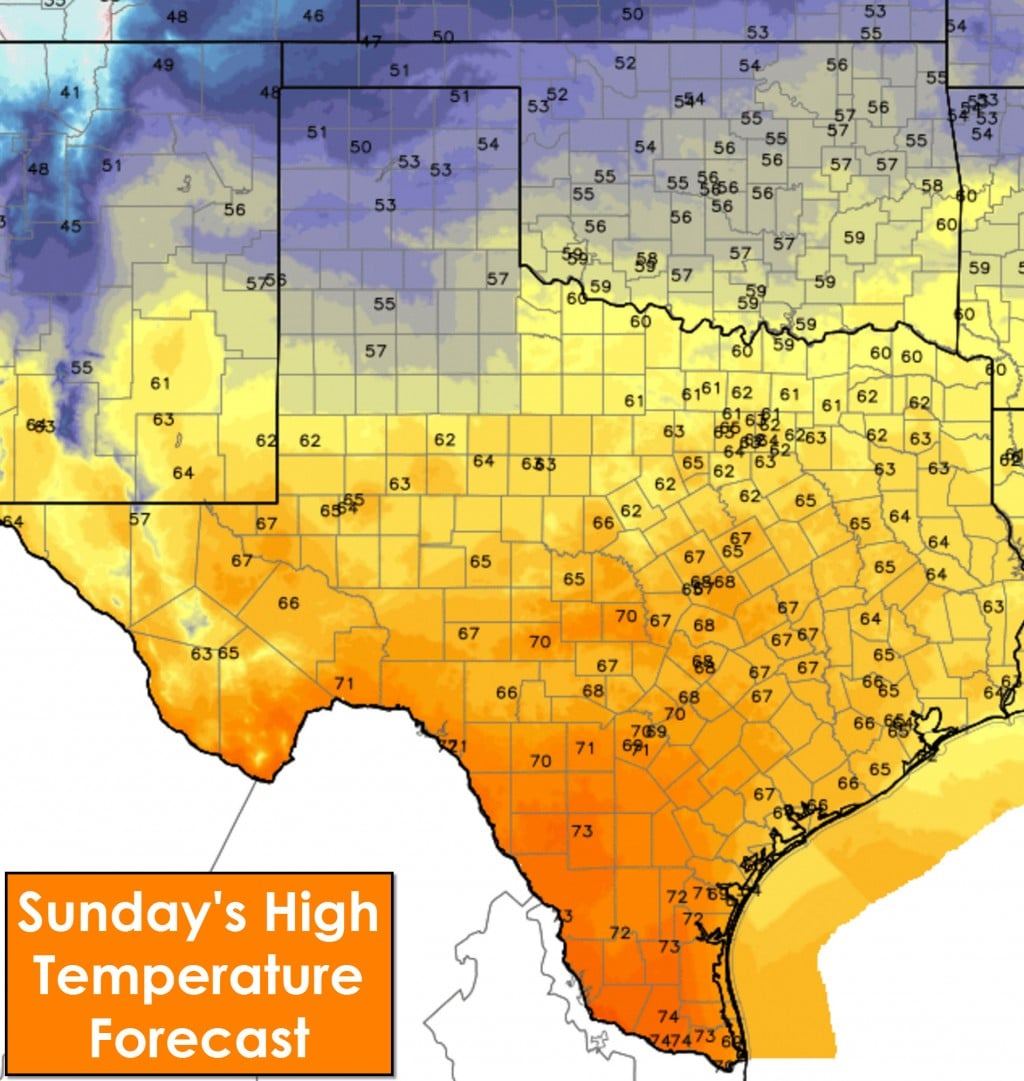
As the upper level storm system pulls away we should see a transition to mostly clear skies by Saturday afternoon across Texas. High temperatures will be warmer across western parts of Texas into Central Texas and Southeast Texas. North Texas and Northeast Texas will remain nearly the same as today. They’ll join in on the warmer weather on Sunday as temperatures continue to increase across most of Texas with 60s and 70s. The Panhandle will be cooler as another surge of cooler air moves in. Low temperatures on Sunday morning will still be cool with 20s to low 40s across Texas.

0 Comments