

This afternoon will be the last relatively warm one for the next couple of days across the eastern half of Texas. High temperatures will peak in the mid 60s to mid 70s along and east of Highway 281 today. That includes North Texas, East Texas, Southeast Texas, Central Texas, and South-Central Texas. As usual folks in Deep South Texas and the Rio Grande Valley will top out in the upper 70s to right around 80 degrees. It’ll be a drastically different picture across the Panhandle where cold air advection will be in full force today. Y’all will struggle to make it out of the 30s this afternoon with a biting north wind. The South Plains, Rolling Plains, Permian Basin, and Northwest Texas will range from the mid 40s to upper 50s. I wouldn’t be surprised to see temperatures struggle to climb much by this afternoon as cold air advection continues. We do note that high winds are possible again today in the Guadalupe and Davis Mountains.
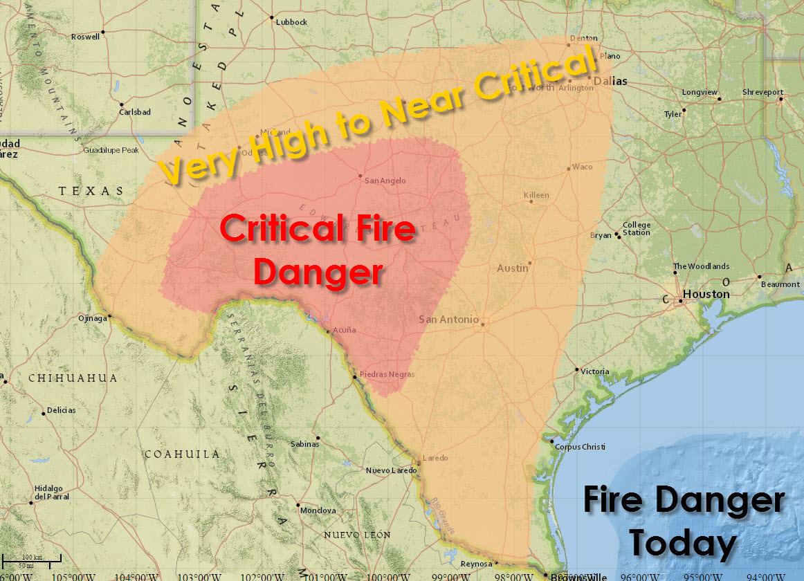
The initial cold front this morning won’t result in cooler temperatures this afternoon for the eastern half of Texas. What it will do is bring in much drier air. Combined with gusty west winds and low humidity we’re looking at another day with critical fire danger. The highest risk for explosive wildfire growth will be across Southwest Texas and the Concho Valley. Very high to near-critical fire danger exists across the Permian Basin, South Texas, Central Texas, Hill Country, North Texas, and the Big Country. Compared to the past few days the risk for enhanced fire danger has spread further east. Local fire departments should be prepared for an increased risk of grass fires today. Any fire that develops could spread rapidly and require considerable resources to contain.


Far West Texas, the Guadalupe and Davis Mountains, into the Permian Basin, South/Rolling Plains, and the Texas Panhandle are going to be cold tonight into Wednesday morning. Low temperatures will range from the upper 10s in Alpine and the northern Texas Panhandle into the mid and upper 20s across the Plains and Permian Basin. Freezing temperatures are anticipated across Northwest Texas, the Big Country, Concho Valley, western North Texas, and parts of the Hill Country. The remainder of North Texas, Northeast Texas, East Texas, the Brazos Valley, Central Texas, South-Central Texas, and the Hill Country will be in the mid to upper 30s tonight. Southeast Texas, the Coastal Plains, and South Texas will range from the upper 30s to the mid 40s. Finally we’ll round out with the upper 40s in the Rio Grande Valley for low temperatures tonight in the Rio Grande Valley.

The storm system that brought high winds and blowing dust to West Texas is now causing a multitude of new problems to our north and east. A raging blizzard is impacting Nebraska and Iowa today. Meanwhile a severe weather episode will unfold this afternoon and tonight across Tennessee, Mississippi, and Alabama. A squall line will move east with widespread damaging winds. Any sustained discrete storms that fire up ahead of that line could become tornadic this afternoon across northern Mississippi, southern Tennessee, and northwest Alabama. Back here in Texas we won’t be dealing with anything like that this week. Our weather looks dry through at least Thursday Night.


0 Comments