
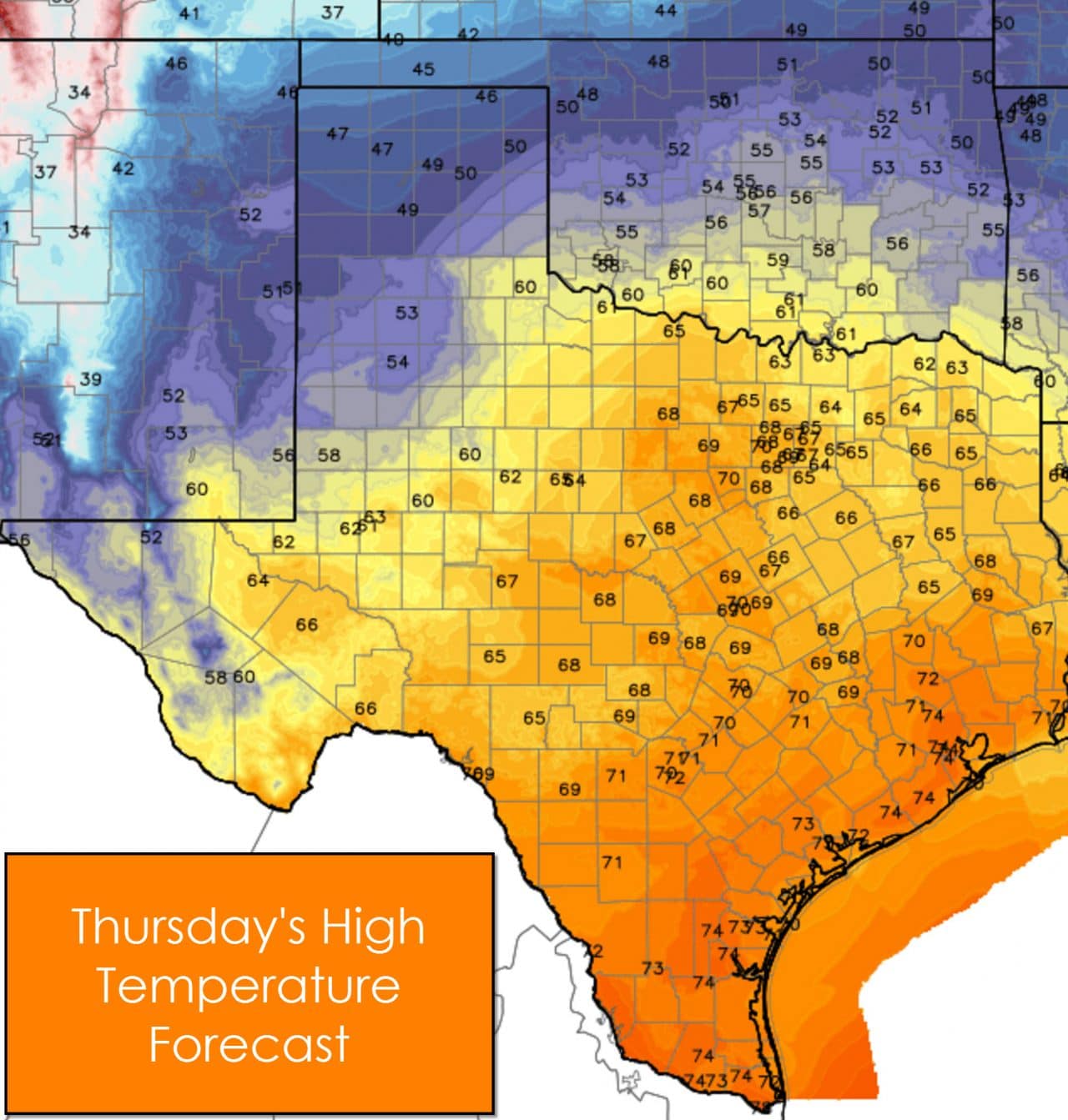
It’s a foggy morning across parts of Texas. As the rain and clouds have moved out that allowed fog to form in some areas. In fact some of the fog has become quite dense this morning and could prove to be a hindrance on your morning commute. Give yourself a little extra time for the drive this morning and only use your low-beam headlights and fog lights. The fog should start lifting by mid-morning as temperatures warm up. It’ll be a nice day for the eastern two-thirds of Texas with above-average temperatures. Highs should climb into the 60s and 70s from the Big Country, COncho Valley, Permian Basin, and points east. South-Central Texas, Southeast Texas, South Texas, and the Rio Grande Valley will warm up into the low to middle 70s this afternoon. The Texas Panhandle looks to be cooler than what we expected in yesterday’s forecast. A few showers are possible with high temperatures staying in the upper 40s to right around 50 degrees. A little snow may mix in up there this afternoon but will clear out by this evening.
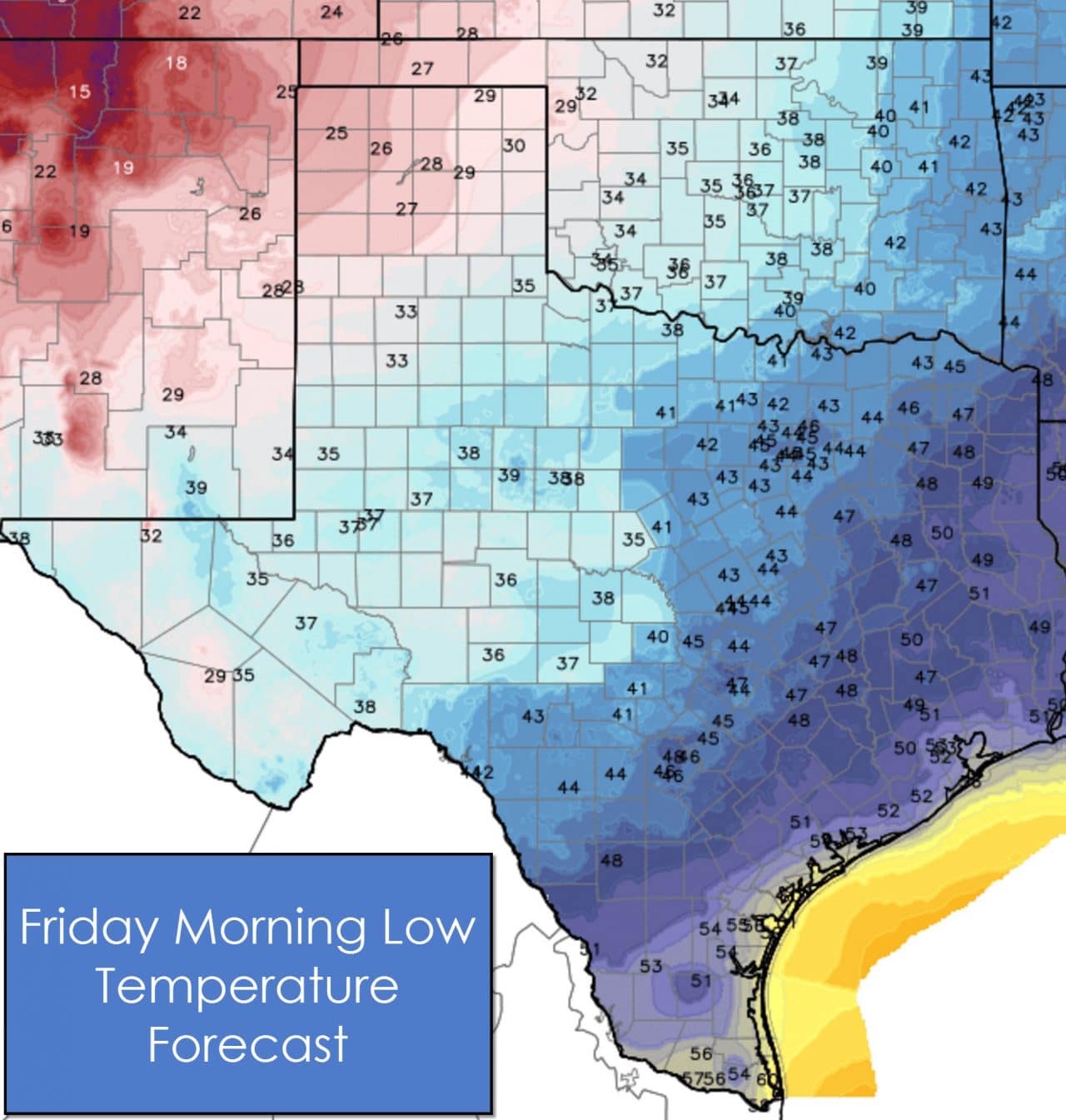
Tonight will feature cool temperatures across the western half of Texas while the eastern half is a bit warmer. Upper 20s are expected across the Panhandle with 30s in the South Plains, Rolling Plains, Permian Basin, Far West Texas, Northwest Texas, Big Country, and Concho Valley. 40s will be common across North Texas, Central Northeast Texas, East Texas, and Southeast Texas. The Rio Grande Valley, South Texas, and the immediate coast will be in the 50s tonight. Fog will be a possibility once again by Friday morning.
Our weather will become more active on Friday as a cold front pushes south. Snow will be possible across the Panhandle with strong storms a possibility in Northeast Texas, East Texas, and Southeast Texas. Nothing like December 26-27 is expected and both aspects of the storm-system will be marginal. We’ll talk more about tomorrow’s weather forecast along with the big-time cool off arriving by the weekend in a blog later on today.
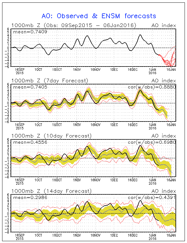
A little side note for this morning’s blog. One reason that we’ve had such warm weather over the past few months is that the Arctic Oscillation Index (AO) has been positive. In an El Nino winter you typically need the AO to be negative for stronger cold air intrusions. The top-chart shows the AO since September. The red lines on that graph show various ensemble member forecasts for the next ten days. Take note that all of them show the index becoming strongly negative. That means our chance for a colder period of weather is increasing for Mid-January. There are signs it may be an interesting period of weather – but time will tell.


0 Comments