
Good morning and Merry Christmas everyone! We’re starting off with fog across Southeast Texas and South Texas this morning while some folks are starting off with cloudy skies. We’ll see cloud cover increase across all of Texas by this afternoon and tonight. Temperatures this afternoon will be warm across most of Texas. In fact we’ll likely start to see some showers by tonight as moisture levels increase to ridiculous values for December. I don’t expect any severe weather or thunderstorm issues today or this evening. We could have an isolated severe storm after midnight as lift increases across North Texas and East Texas. The significant weather problems will hold off until Saturday for most locations.

A severe weather event is looking more likely on Saturday across the eastern Concho Valley, the Hill Country, Central Texas, North Texas, and portions of East Texas. At this time an elevated risk (Level 2 out of 5) of severe weather is in place for those regions. I would not be shocked to see a portion of that zone upgraded to an enhanced risk of severe weather (level 3 out of 5) in later outlooks as details become more clear. The atmosphere will become quite unstable for December by Saturday afternoon. At the same time wind shear values will be very favorable for organized thunderstorms. Low-level wind shear will be impressive in both speed shear and turning with height. All modes of severe weather will be possible. That means large hail, damaging wind gusts, and tornadoes will be possible. The threat for tornadoes will be highest with any intense discrete supercells that form during the afternoon and evening hours Saturday. Damaging wind gusts will be the biggest issue with a line of storms that should impact North Texas during the evening hours on Saturday. This does have the potential to be a problematic severe weather day so please have a way to receive severe weather warnings and check back for updates.

The risk for severe weather will continue on Sunday south of a cold front that should be located over North Texas. The severe weather risk looks to include Central Texas, South Texas, Southeast Texas, East Texas, and Northeast Texas. If the cold front is a bit slower the severe weather risk could also continue in North Texas. Damaging wind gusts over 60 MPH are the primary risk on Sunday but large hail and a couple tornadoes could occur. The risk zone will be refined as the exacts of the setup become more clear.
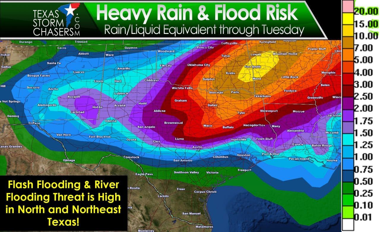
A major flood event is poised to unfold across North Texas, Northeast Texas, and East Texas beginning Saturday and continuing through Sunday and perhaps even into Monday. Widespread rain accumulations of 3 to 6 inches are expected across North Texas. Folks north and northeast of the D/FW Metroplex into Northeast Texas could receive 4 to 7 inches of rain. Isolated rain totals near 10 inches will be possible. It will not be raining all the time this weekend as there will be several ‘waves’ of activity. The flash flooding risk is very high with this event. Significant rises on lakes and rivers will probably occur into next week. Most locations can handle up to 1.5 inches of rain in a day before flooding issues become more common. Soils remain saturated from previous rain events and dormant winter vegetation cannot absorb much water. Moisture levels in the atmosphere will be in record-high territory for late December.
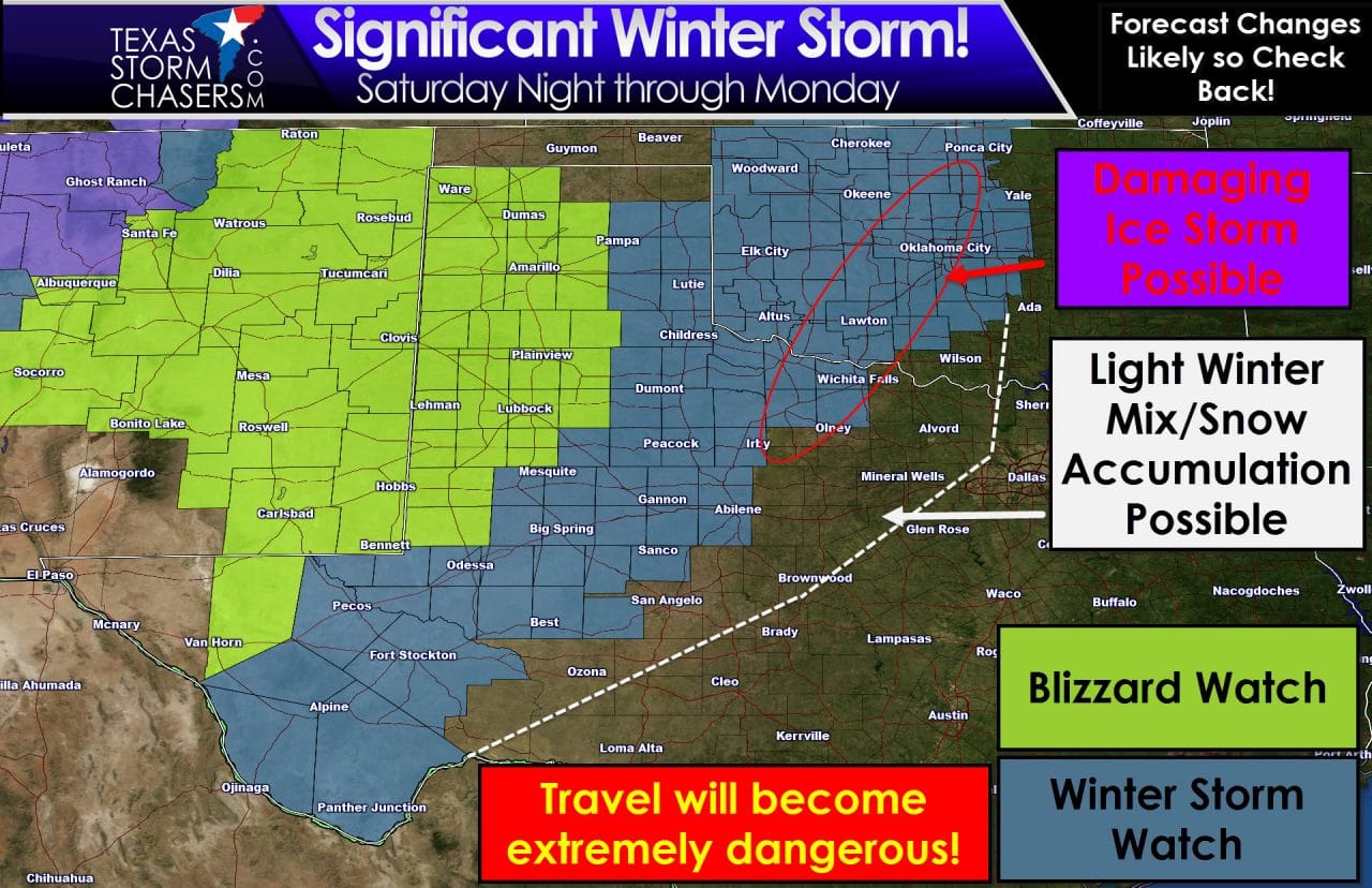
Moisture levels will also be ridiculously high on the cold side of our storm system. These moisture levels will allow for a major winter storm with heavy snows. Blizzard watches are in effect for most of the Texas Panhandle and the South Plains. A Winter Storm Watch is in effect for Northwest Texas, the Big Country, the northwest half of the Concho Valley, and the Permian Basin. A Winter Storm Warning is already in effect for El Paso in Far West Texas. Impacts across the Blizzard Watch and Winter Storm Watch areas will be nearly identical in terms of potential accumulations. Blizzard conditions are possible across both watch areas. Please realize this is likely to become the most significant winter storm we’ve dealt with in years. I do expect road closures (including major highways) on Sunday continuing into Monday across the Texas Panhandle, West Texas, Permian Basin, Northwest Texas, and perhaps part of the Concho Valley and Big Country. Travel will be extremely dangerous. If you’re going to be traveling you need to have a winter weather survival kit. Have enough food and water to last a couple days. Have blankets and a shovel to keep snow away from your exhaust. With powerful north winds snow drifts in the most hard hit areas could easily bury a vehicle. Plan on being off the roads by late Saturday or very early Sunday. Do not travel on Sunday or Monday. If you’re in the ‘impacted’ regions you can expect to be stuck there until early next week. This could go down as a historic blizzard.
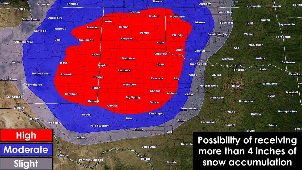
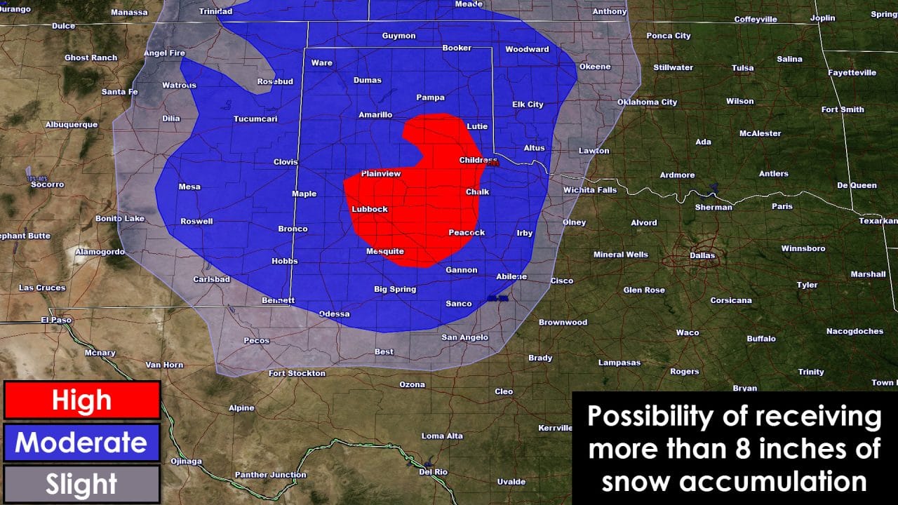

These graphics indicate the likelihood of receiving a certain amount of snow. Widespread snow accumulations of 4 to 8 inches are anticipated across the Texas Panhandle, West Texas, portions of the Big Country and Northwest Texas. I do expect localized amounts of 12 to 18 inches across West Texas – although the exact location of heaviest snows will depend on where the low pressure tracks. A major ice storm is possible across Northwest Texas northeast into Central Oklahoma. With north winds gusting over 40 MPH there is the potential for long-duration power outages even in locations that receive light icing. The ‘ice zone’ will depend on where we see our winter mix set up. This is something I’m hoping we can zone in on later today or early Saturday as weather models converge on a solution. On Monday rain may change over to light snow along and west of Interstate 35 in North Texas. Slick bridges/overpasses are possible west of I-35. We’ll refine this aspect of the forecast as well once we get closer to Monday.


0 Comments