
A Tornado Watch is now in effect for Northeast Texas and East Texas until 7 AM. The watch runs along and east of a Clarksville-Emory-Palestine-Trinity line including Lufkin, Tyler, Atlanta, and Texarkana. Scattered thunderstorms are developing in an unstable atmosphere with strong wind shear. Some storms could become severe with large hail, localized damaging winds, and isolated tornadoes. Most activity will exit Texas to the east by 9 AM if not a bit before.
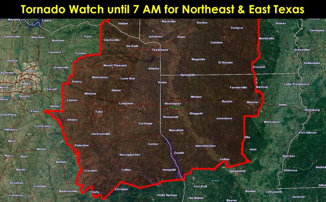
 TORNADO WATCH NUMBER 556
   NWS STORM PREDICTION CENTER NORMAN OK
   1205 AM CST WED DEC 23 2015

   THE NWS STORM PREDICTION CENTER HAS ISSUED A

   * TORNADO WATCH FOR PORTIONS OF
     SOUTHWEST ARKANSAS
     NORTHWEST LOUISIANA
     SOUTHEAST OKLAHOMA
     EAST TEXAS

   * EFFECTIVE THIS WEDNESDAY MORNING FROM 1205 AM UNTIL 700 AM CST.

   * PRIMARY THREATS INCLUDE...
     A COUPLE TORNADOES POSSIBLE
     SCATTERED LARGE HAIL AND ISOLATED VERY LARGE HAIL EVENTS TO 2
       INCHES IN DIAMETER POSSIBLE
     ISOLATED DAMAGING WIND GUSTS TO 70 MPH POSSIBLE

   SUMMARY...THUNDERSTORMS...SOME WITH HAIL AND...WITH TIME...POSSIBLY
   A COUPLE TORNADOES...EXPECTED TO DEVELOP / INCREASE OVER EAST TEXAS
   AND ADJACENT PARTS OF ARKANSAS AND LOUISIANA AS WARM ADVECTION /
   MOISTURE TRANSPORT STRENGTHEN DOWNSTREAM FROM AMPLIFYING NORTHWEST
   TEXAS UPPER TROUGH.


0 Comments