
This morning’s immediate weather hazard comes in the form of dense fog. The Rio Grande Valley, South Texas, the Coastal Plains, and Southeast Texas are all encompassed in dense fog this morning. All the fog is caused by increasing low-level moisture ahead of our storm system this weekend. I expect fog will continue to be a morning hazard for the remainder of the work week. Like yesterday most locations should see fog burn off by late morning. Those of you looking outside and asking ‘What fog?’ will just have to find out later on this week. Temperatures just before sunrise have fallen into the 30s across the Texas Panhandle, West Texas, and Permian Basin with upper 40s to low 50s across North Texas, Southeast Texas, and South Texas. The Rio Grande Valley is sitting right at 60 degrees which is decently warm for a December morning.
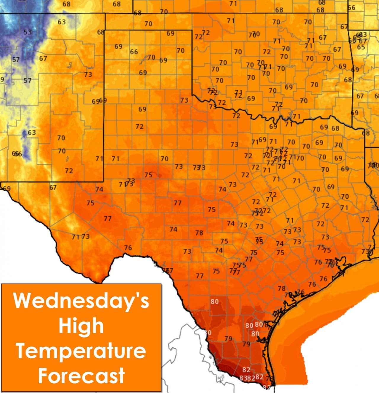
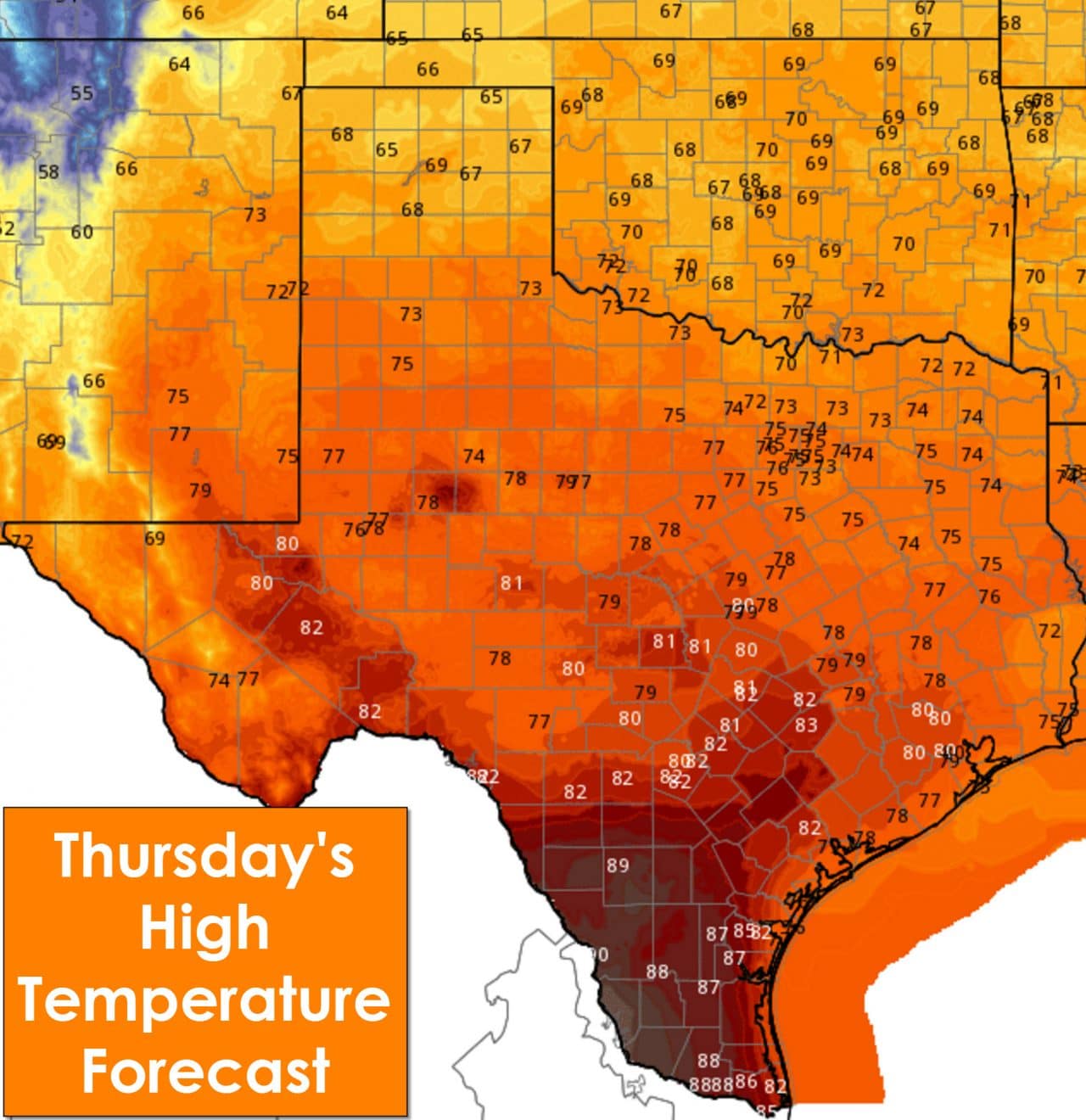
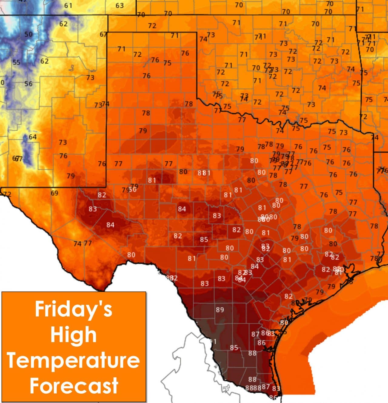
Before we have to deal with any precipitation issues this weekend the weather will remain fairly nice across Texas. High temperatures continue to be well above average and by Friday will approach near-record high territory. Most of the state will top out in the 70s today with 80s becoming more common on Thursday and Friday. Parts of Deep South Texas may even make it up into the lower 90s by Friday. This is December right? No worries – cooler temperatures will arrive by Sunday and Monday.
Overnight temperatures will also become warmer leading up to Saturday as moisture levels increase. Most folks across the eastern two-thirds of Texas will only drop down into the 50s by Friday morning with 60s by Saturday morning. In case you were wondering the low temperature on Saturday for our Interstate 35 cities could be near or only a few degrees below the average HIGH temperature for a December day. All the moisture that will be in place by Saturday will help create our next precipitation event.
Folks across the eastern half of Texas will wake up to a warm and humid morning on Saturday. Frankly its going to feel more like April than December. At this point we’re expecting showers/storms to increase in coverage and intensity late Saturday afternoon near or just west of Interstate 35. A broken line of storms looks to move east through the Interstate 35 corridor late Saturday afternoon into the evening hours from southern Oklahoma south through North and perhaps even parts of Central Texas. A band of heavy showers and thunderstorms will than move slowly east across Northeast Texas and East Texas during the nighttime hours on Saturday into Sunday. Being four days out I’m sure we’ll see some of the timing and location aspects adjusted as we get closer.
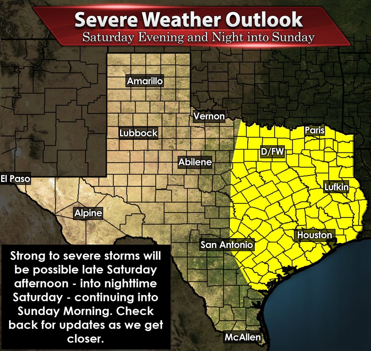
There will be the potential for severe thunderstorms and a flash flooding threat with this upcoming system. Being four days out I’m sure our long-time followers will know that things are far from being set in stone. As of the latest outlook from the Storm Prediction Center they’re placing most of Northeast Texas, East Texas, Southeast Texas, and locations along and east of Interstate 35 from Oklahoma City south through the D/FW Metroplex, Waco, Austin, to San Antonio in a severe weather risk for Saturday evening through Sunday. The severe weather setup will be characterized by strong wind shear but with a marginally unstable airmass. These setups are more common in the winter months and rely more on the kinematics (wind shear) versus thermodynamics (instablity-driven). The severe weather threat doesn’t look high-end or significant but we could end up having some issues. We’ll refine the forecast as we get closer to the weekend. Damaging wind gusts and a couple of tornadoes would be possible with the strongest storms.

Potential rain accumulations from Friday through Monday
The precipitation-aspect of the event is a little more clear. The heaviest rain amounts will be located across Northeast Texas and East Texas where three to five inches of rain may fall. An inch to two inches of rain will be possible along and east of Interstate 35 from the Red River south through Central Texas and points east. Lighter rain totals will be possible across the Big Country, Concho Valley, and Hill Country. If the storm system slows down or accelerates in future forecasts that will result in the rain chances changing as well.

Texas Panhandle Snow Potential this weekend
Finally we may have some light snow fall across the Texas Panhandle on Saturday where colder air will be in place. At this time snow accumulations look like with perhaps 1 to 2 inches possible. Like I said above we’ll continue to refine the forecast. Much cooler temperatures will follow behind the storm system on Sunday into next week.


0 Comments