
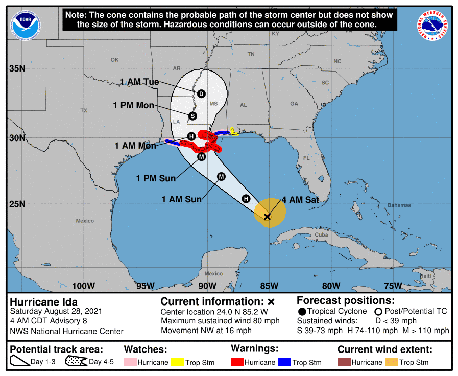
Hurricane Ida is skedaddling from Cuba and moving northwest in the Gulf of Mexico. At 4 AM, the center of Ida was located 510 miles southeast of New Orleans. Movement is to the northwest, around 16 miles per hour. Both the forward rate and direction are expected to continue today and tomorrow. No significant impacts from Ida (weather-wise) are expected in Texas.
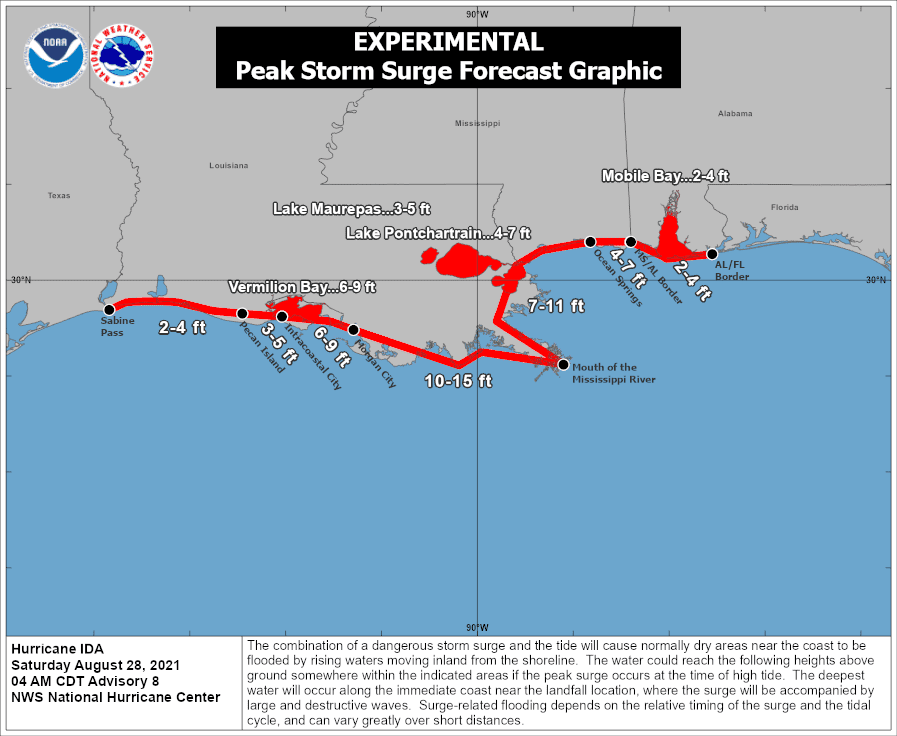
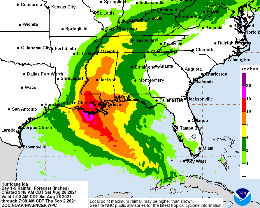
Landfall is expected Sunday evening in Southern/Southeastern Louisiana as a category four major hurricane. Dangerous winds and storm surge are likely near and to the east of the center. Dangerous storm surge could extend well east of the landfall location, including along the Mississippi coastline. Ida will slow and turn north after landfall. Copious amounts of rain, locally exceeding 15 inches, will create a high risk of fresh-water flooding in New Orleans and eastern Louisiana.
New-Orleans
Let us hope the 50 billion dollars spent after Katrina to protect New Orleans from flooding do their job. They’ve got a 10 to 15-foot storm surge and 15 inches of rain heading their way. Oh, let us not forget the 90-120 MPH winds – which may be higher if Ida makes landfall closer to the city. Ida will be a stress test on the city’s flood control measures. Considering they’ve chosen to mostly shelter in place within the levee system, let us hope the post-Katrina work was enough, lest history repeats itself. New Orleans ranges from six feet below sea level to twenty feet above, with a population of around 384,000. The worst impacts will be tomorrow night through Monday morning. However, some tidal surges are already being noted and several inches of heavy rain (not associated with Ida) fell on Friday.
We’re in Louisiana to document Ida
One TSC team arrived in Louisiana early this morning. At least one more will be joining them tonight. They’ll be scouting out a safe, stationary intercept location before the hurricane’s impacts begin tomorrow. The team is well-stocked and can be self-sufficient for several days. They’ll be posting multiple updates on our social media platforms today. We’ll have live video from their location during the hurricane’s arrival on our YouTube channel and here on the Texas Storm Chasers website.
Key Messages for Ida
1. There is a danger of life-threatening storm surge inundation Sunday along the coasts of Louisiana and Mississippi within the Storm Surge Warning area. Extremely life-threatening inundation of 10 to 15 feet above ground level is possible within the area from Morgan City, Louisiana, to the Mouth of the Mississippi River. Interests throughout the warning area should follow any advice given by local officials.
2. Ida is expected to be an extremely dangerous major hurricane when it reaches the coast of Louisiana. Hurricane-force winds are expected Sunday in portions of the Hurricane Warning area along the Louisiana coast, including metropolitan New Orleans, with potentially catastrophic wind damage possible where the core of Ida moves onshore. Actions to protect life and property should be rushed to completion in the warning area.
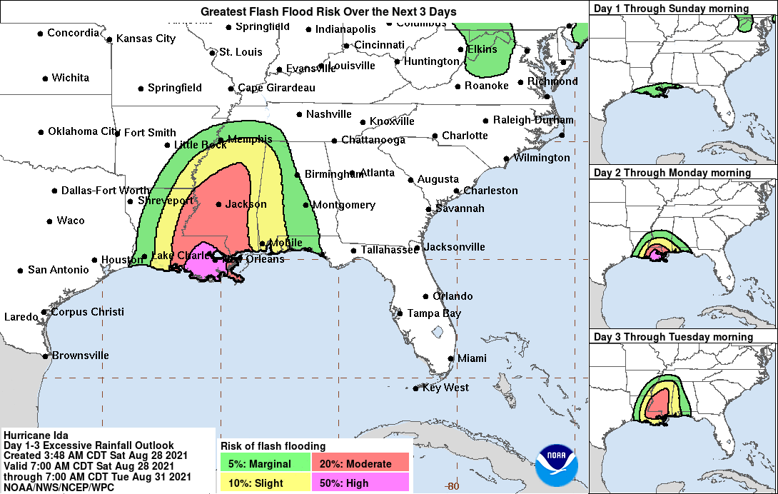
3. Ida is likely to produce heavy rainfall later Sunday into Monday across the central Gulf Coast from southeast Louisiana to coastal Mississippi resulting in significant flash and riverine flooding impacts. As Ida moves inland, flooding impacts are possible across portions of the Lower Mississippi and Tennessee Valleys.
Full 4 AM Ida Advisory
Hurricane Ida Advisory Number 8
NWS National Hurricane Center Miami FL AL092021
400 AM CDT Sat Aug 28 2021
…IDA CONTINUES MOVING NORTHWESTWARD ACROSS THE SOUTHEASTERN
GULF OF MEXICO…
…FORECAST TO RAPIDLY INTENSIFY BEFORE REACHING THE NORTHERN GULF
COAST…
SUMMARY OF 400 AM CDT…0900 UTC…INFORMATION
———————————————-
LOCATION…24.0N 85.2W
ABOUT 510 MI…825 KM SE OF NEW ORLEANS LOUISIANA
ABOUT 185 MI…300 KM WNW OF HAVANA CUBA
MAXIMUM SUSTAINED WINDS…80 MPH…130 KM/H
PRESENT MOVEMENT…NW OR 315 DEGREES AT 16 MPH…26 KM/H
MINIMUM CENTRAL PRESSURE…987 MB…29.15 INCHES
WATCHES AND WARNINGS
——————–
CHANGES WITH THIS ADVISORY:
The Government of Cuba has discontinued all warnings for Cuba.
SUMMARY OF WATCHES AND WARNINGS IN EFFECT:
A Storm Surge Warning is in effect for…
* East of Rockefeller Wildlife Refuge Louisiana to the
Mississippi/Alabama border
* Vermilion Bay, Lake Borgne, Lake Pontchartrain, and Lake Maurepas
A Hurricane Warning is in effect for…
* Intracoastal City Louisiana to the Mouth of the Pearl River
* Lake Pontchartrain, Lake Maurepas, and Metropolitan New Orleans
A Storm Surge Watch is in effect for…
* Sabine Pass to Rockefeller Wildlife Refuge Louisiana
* Mobile Bay
A Hurricane Watch is in effect for…
* Cameron Louisiana to west of Intracoastal City Louisiana
* Mouth of the Pearl River to the Mississippi/Alabama border
A Tropical Storm Warning is in effect for…
* Cameron Louisiana to west of Intracoastal City Louisiana
* Mouth of the Pearl River to the Mississippi/Alabama border
A Tropical Storm Watch is in effect for…
* Mississippi/Alabama border to the Alabama/Florida border
A Storm Surge Warning means there is a danger of life-threatening
inundation, from rising water moving inland from the coastline,
during the next 36 hours in the indicated locations. For a
depiction of areas at risk, please see the National Weather
Service Storm Surge Watch/Warning Graphic, available at
hurricanes.gov. This is a life-threatening situation. Persons
located within these areas should take all necessary actions to
protect life and property from rising water and the potential for
other dangerous conditions. Promptly follow evacuation and other
instructions from local officials.
A Hurricane Warning means that hurricane conditions are expected
somewhere within the warning area. A warning is typically issued
36 hours before the anticipated first occurrence of
tropical-storm-force winds, conditions that make outside
preparations difficult or dangerous. Preparations to protect life
and property should be rushed to completion.
A Tropical Storm Warning means that tropical storm conditions are
expected somewhere within the warning area within 36 hours.
A Storm Surge Watch means there is a possibility of life-
threatening inundation, from rising water moving inland from the
coastline, in the indicated locations during the next 48 hours.
A Hurricane Watch means that hurricane conditions are possible
within the watch area. A watch is typically issued 48 hours
before the anticipated first occurrence of tropical-storm-force
winds, conditions that make outside preparations difficult or
dangerous.
A Tropical Storm Watch means that tropical storm conditions are
possible within the watch area, generally within 48 hours.
Interests elsewhere along the northern U.S. Gulf coast should
monitor the progress of this system.
For storm information specific to your area, including possible
inland watches and warnings, please monitor products issued by your
local National Weather Service forecast office.
DISCUSSION AND OUTLOOK
———————-
At 400 AM CDT (0900 UTC), the center of Hurricane Ida was located
near latitude 24.0 North, longitude 85.2 West. Ida is moving toward
the northwest near 16 mph (26 km/h) and this general motion should
continue through late Sunday or early Monday. A slower northward
motion is forecast on Monday. On the forecast track, the center of
Ida will move over the southeastern Gulf of Mexico today and over
the north central Gulf of Mexico on Sunday. Ida is then expected
to make landfall along the U.S. northern Gulf coast within the
hurricane warning area by late Sunday or early Monday, then move
through portions of Louisiana or western Mississippi later on
Monday.
Maximum sustained winds are near 80 mph (130 km/h) with higher
gusts. Rapid strengthening is forecast during the next 24 to 36
hours and Ida is expected to be an extremely dangerous major
hurricane when it approaches the northern Gulf coast on Sunday.
Weakening is expected after Ida makes landfall.
Hurricane-force winds extend outward up to 25 miles (35 km) from the
center and tropical-storm-force winds extend outward up to 115 miles
(185 km).
The estimated minimum central pressure is 987 mb (29.15 inches).
HAZARDS AFFECTING LAND
———————-
Key messages for Ida can be found in the Tropical Cyclone
Discussion under AWIPS header MIATCDAT4, WMO header WTNT44 KNHC,
and on the web at hurricanes.gov/graphics_at4.shtml?key_messages.
STORM SURGE: A dangerous storm surge will raise water levels by
as much as 4 to 6 feet above normal tide levels in areas of onshore
winds along the immediate coast of the Isle of Youth and near and to
the east of where the center crosses the coast of western Cuba.
Near the coast, the surge will be accompanied by large and
destructive waves.
The combination of a dangerous storm surge and the tide will cause
normally dry areas near the coast to be flooded by rising waters
moving inland from the shoreline. The water could reach the
following heights above ground somewhere in the indicated areas if
the peak surge occurs at the time of high tide…
Morgan City, LA to Mouth of the Mississippi River…10-15 ft
Mouth of the Mississippi River to Ocean Springs, MS including Lake
Borgne…7-11 ft
Intracoastal City, LA to Morgan City, LA including Vermilion
Bay…6-9 ft
Ocean Springs, MS to MS/AL border…4-7 ft
Lake Pontchartrain…4-7 ft
Lake Maurepas…3-5 ft
Pecan Island, LA to Intracoastal City, LA…3-5 ft
MS/AL border to AL/FL border including Mobile Bay…2-4 ft
Sabine Pass to Pecan Island, LA…2-4 ft
Overtopping of local levees outside of the Hurricane and Storm
Damage Risk Reduction System is possible where local inundation
values may be higher than those shown above.
The deepest water will occur along the immediate coast near and to
the east of the landfall location, where the surge will be
accompanied by large and dangerous waves. Surge-related flooding
depends on the relative timing of the surge and the tidal cycle,
and can vary greatly over short distances. For information
specific to your area, please see products issued by your local
National Weather Service forecast office.
WIND: Hurricane conditions are expected in the hurricane warning
area along the northern Gulf coast beginning Sunday with tropical
storm conditions expected to begin by late Saturday night or early
Sunday morning. These conditions will spread inland over portions
of Louisiana and Mississippi Sunday night and Monday. Gusty winds
are possible over portions of western Cuba and the Florida Keys
this morning.
RAINFALL: Ida will continue to lift north of Cuba this morning
bringing an additional 2 to 4 inches of rain with isolated maximum
amounts of 6 inches across western Cuba through today. These
rainfall amounts may produce flash floods and mudslides.
As Ida moves into the Louisiana coast late Sunday, total rainfall
accumulations of 8 to 16 inches with isolated maximum amounts of 20
inches are possible across southeast Louisiana and southern
Mississippi through Monday. This is likely to result in significant
flash and riverine flooding impacts.
Ida is forecast to turn northeast as it moves inland later Monday,
with rainfall totals of 4 to 8 inches possible from northeastern
Louisiana and central Mississippi into the Tennessee Valley. This is
likely to result in considerable flash and riverine flooding
impacts.
TORNADOES: A few tornadoes will be possible Sunday through early
Monday across southeast Louisiana and southern Mississippi.
SURF: Swells generated by Ida will continue to affect western Cuba
through Saturday morning. Swells will begin reaching portions of
the northern Gulf coast Saturday night or early Sunday. These
swells are likely to cause life-threatening surf and rip current
conditions. Please consult products from your local weather office.
NEXT ADVISORY
————-
Next intermediate advisory at 700 AM CDT.
Next complete advisory at 1000 AM CDT.


0 Comments