
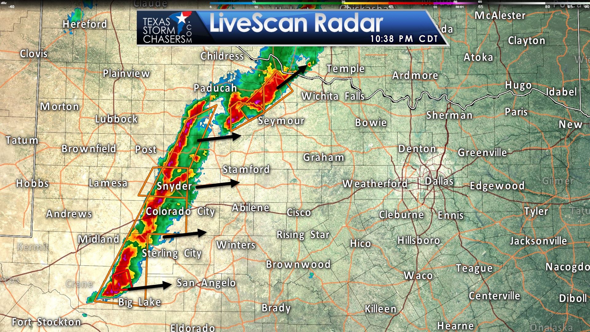
A line of thunderstorms has quickly erupted over the past two hours across portions of Northwest Texas into western sections of the Big Country and Concho Valley. Most of the storms in this squall line are severe with a risk of damaging wind gusts up to 70 MPH and hail up to the size of golfballs. The squall line is racing off to the east at 35 to 50 MPH. A new severe thunderstorm watch is in effect for Northwest Texas and western North Texas through 5 AM. This new watch is in addition to the severe thunderstorm watch covering in the Big Country and Concho Valley. The severe weather threat will continue into the pre-dawn hours as the squall line moves east through Northwest Texas, the Big Country, and Concho Valley. Eventually this line will move into western sections of North Texas, likely after midnight. The primary severe weather threats will be damaging wind gusts up to 70 MPH and quarter to golfball size hail. An isolated/brief tornado cannot be ruled out in more intense sections of the squall line. However, the tornado threat is considerably lower than with the discrete supercells earlier today in the eastern Panhandle and western Oklahoma.
Severe Thunderstorm Watch Number 229
   NWS Storm Prediction Center Norman OK
   1010 PM CDT Tue May 16 2017

   The NWS Storm Prediction Center has issued a

   * Severe Thunderstorm Watch for portions of
     Southern Kansas
     Western and central Oklahoma
     North Texas

   * Effective this Tuesday night and Wednesday morning from 1010 PM
     until 500 AM CDT.

   * Primary threats include...
     Scattered large hail and isolated very large hail events to 2
       inches in diameter possible
     Scattered damaging wind gusts to 70 mph possible
     A tornado or two possible

   SUMMARY...Semi-discrete severe storms will continue to occur on a
   relatively isolated basis, ahead of an increasing band of mostly
   linearly organized storms currently increasing across west/northwest
   Texas. Bouts of severe hail will remain possible, and a relatively
   widespread damaging wind risk may also evolve. A tornado or two
   could also occur, mainly with line-embedded circulations that
   eventually evolve.

This squall line will slowly weaken as it moves toward the Interstate 35 corridor by about 4-6AM. I do believe Interstate 35 will see rain/storms pre-dawn Wednesday, but the severe weather threat should be low by that point. Still, it won’t be a pleasant morning commute into work.


0 Comments