

Active spring-like weather is expected to influence Texas this week. The calendar may say it’s still winter, but we all know it’s emulated spring for the last month. Our primary issue last week was wildfires and fire weather. For this week, Mother Nature will be introducing thunderstorms to the mix.
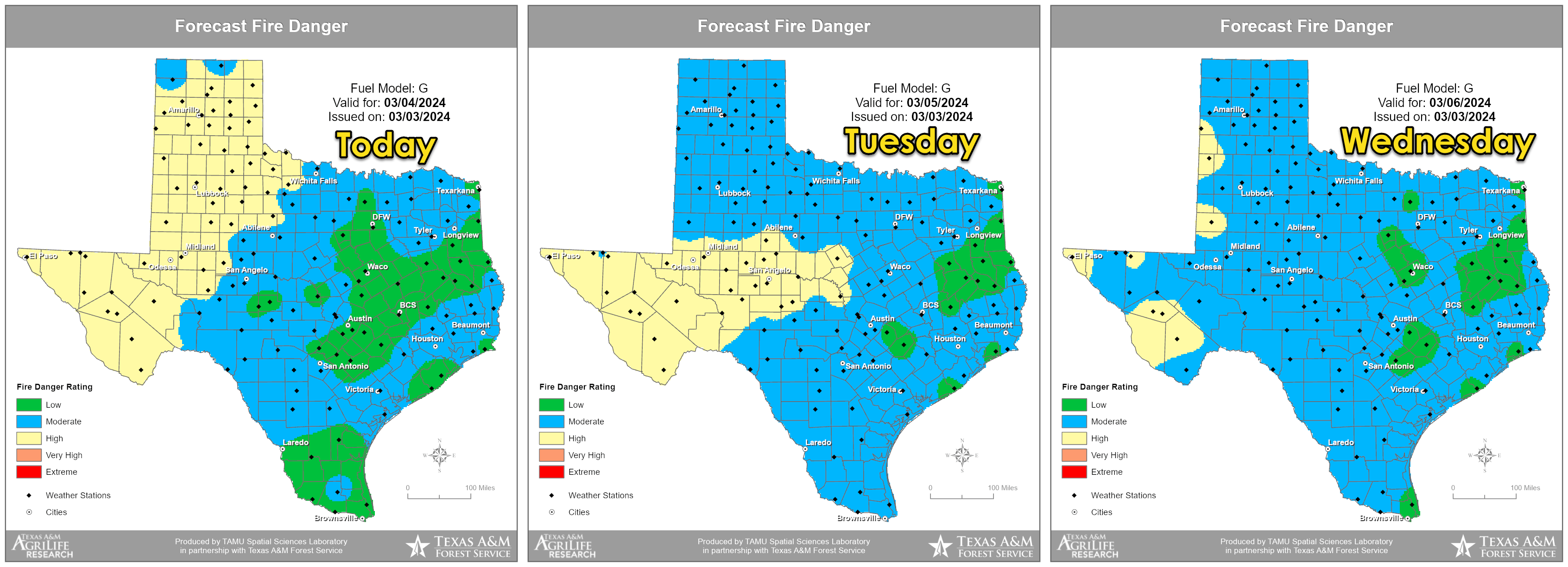
The fire-weather forecast for Texas through Wednesday features a high to very high risk for the western third of Texas. Conditions will moderate as we head into Wednesday and the second half of this week.
A few storms possible (but not likely) Today and Tonight
Fire weather concerns will remain this week across the western half of Texas. However, the overall risk will be less intense than last week and this past weekend. New fires may still resist initial attack efforts, though they should generally be successful. Yesterday’s 300-acre #RoughneckFire near Sanford in the Texas Panhandle exemplifies more successful IA efforts. The overall risk will likely moderate further late in the week with increasing cloud cover, precipitation chances, and cooler weather.
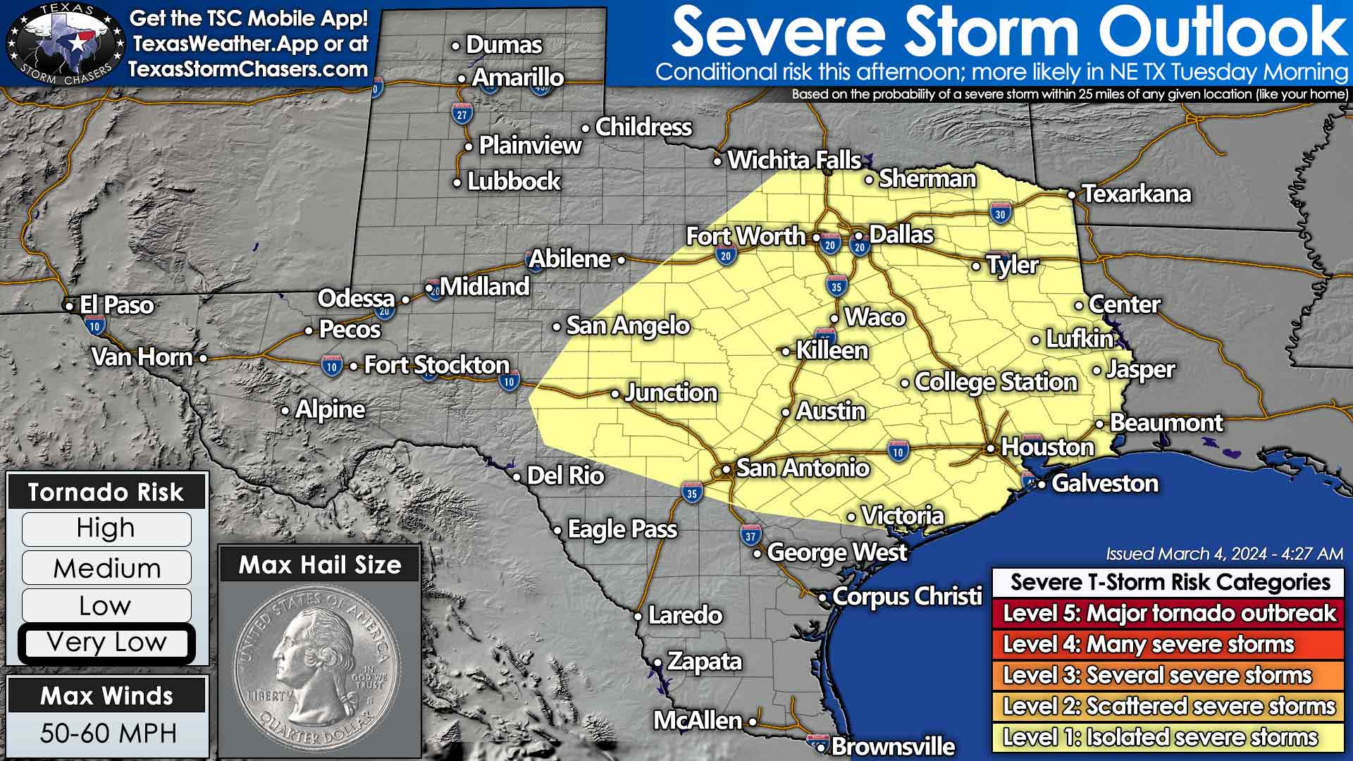
An isolated severe thunderstorm can’t be ruled out today, tonight, or on Tuesday across the eastern half of Texas. Pocket change size hail would be the most likely concern if we had to deal with any rowdy storms. Overall, the threat is low – and most folks won’t even see rain.
A few showers and storms are possible this morning across the Ark-La-Tex and East Texas. Some of those storms, should they occur, may become strong with hail. A conditional chance for a strong storm will exist this afternoon in the Edwards Plateau, Central Texas, and North Texas. Most weather model guidance keeps those regions dry. However, large hail would be a concern if a thunderstorm can perk up. A few storms are possible on Tuesday Morning in the Ark-La-Tex and again Tuesday afternoon from the Ark-La-Tex southwest into the Hill Country with a southward moving cool front. With this forecast, we’re not anticipating widespread storms. Hail and gusty winds could occur with stronger storms.
While we don’t expect many storms tonight, we expect plenty of dense fog. The eastern half of Texas will have at least patchy dense fog tonight through mid-morning Tuesday. Widespread fog, likely reducing visibilities below one-quarter mile, is expected across the Rio Grande Valley, South Texas, the Hill Country, Brazos Valley, Southeast Texas, and East Texas tonight through mid-morning Tuesday. Folks will want extra time for the morning drive and check with airlines for flight delays.
Late-Week Thunderstorm Chances
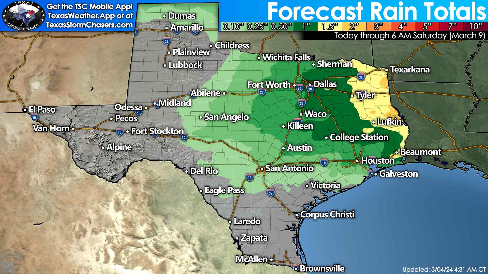
Forecast rain totals through Saturday morning across Texas. One to two inches of rain will be possible across the eastern third of Texas. Thursday and Friday look to be our two wettest days. Light rains are also possible in the Texas Panhandle, Northwest Texas, south into the Big Country and Concho Valley.
On Thursday and Friday, an upper-level storm system will bring thunderstorm chances to the eastern two-thirds of Texas, along with Northwest Texas and the Panhandle. Weather model data is still throwing out a couple of different timelines, but we could have some activity underway by Thursday morning, or we may not start until Thursday night. Regardless, we expect Thursday Night into Friday morning to feature storm chances in the eastern half of Texas. Some storms may be strong, so we must monitor data over the next few days. Perhaps some new content for our storm-chasing channel? Heavy rainfall is also possible, especially for the eastern third of Texas. A stronger cold front will arrive on the backside of our late-week storm system, setting up a cooler weekend.
0 Comments