
A few showers and storms with small hail are possible in the Ark-La-Tex this morning. Isolated strong storms are possible around Del Rio to Eagle Pass on Wednesday evening. A higher chance of thunderstorms returns on Thursday to Texas as a cool front moves south, with numerous showers and thunderstorms across most of the state Friday night and Saturday.
Yesterday’s Storms (or lack thereof)
The Big Country and Northwest Texas had to deal with a few fast-moving hail storms last evening. As explained in yesterday’s Texas Weather Roundup, one possibility was that we’d have too strong of a cap (lid) for longer-lived, more numerous storms yesterday. That ended up being the case, as most storms struggled. Thankfully, that prevented what could have been a significant severe weather threat. Of course, that also creates a ‘crying wolf’ issue, but that’s why I explained a few scenarios.
Weather Today and Wednesday
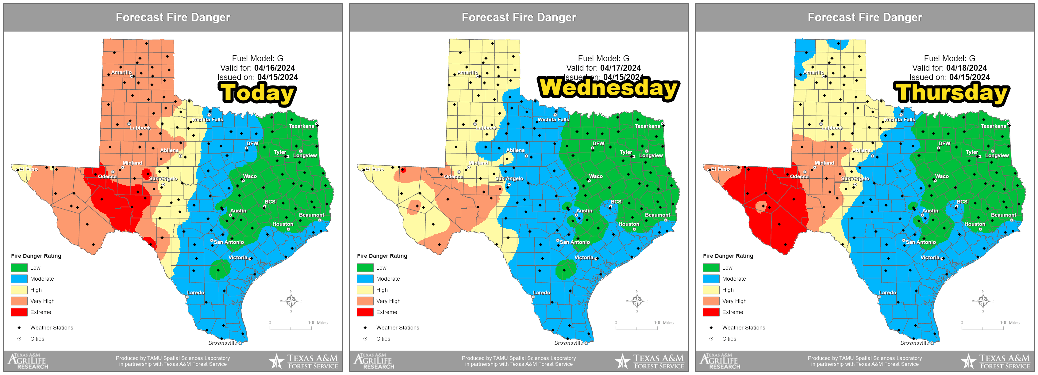
Severe thunderstorms are unlikely this afternoon in Texas thanks to the continuation of the strong cap (lid) on the atmosphere. The Storm Prediction Center has removed the previous severe weather risks outlined for the Ark-La-Tex. This morning’s showers are going to be the main show. Very high to extreme wildfire danger is expected for the western half of Texas, with acrid air west of the dryline.
Much of Texas will remain dry tomorrow, except for low thunderstorm chances in the Edwards Plateau from storms in northern Mexico. If those storms reach the International Border, they could be strong with hail.
Storms and a Cold Front (Thursday through Saturday)

A cold front that actually deserves the name this time will move south into Texas on Thursday and Friday. Scattered thunderstorms are possible Thursday afternoon into Thursday evening from the Ark-La-Tex southwest through North Texas, Central Texas, the Hill Country, and the Edwards Plateau. Some storms may be strong to severe, with large hail, damaging winds, and heavy rainfall. Storms should diminish in both coverage and intensity by the late evening.
Friday Night and Saturday look wet across much of Texas, though the threat of severe thunderstorms looks lower – with the primary issue becoming localized flooding from heavy rainfall. Temperatures will be much cooler across the northern two-thirds of Texas by Saturday. The northern third of Texas may experience high temperatures in the 40s and 50s – especially if rain chances continue to look promising. We’ll also see a nice cooldown along and north of Interstate 10.
Helpful Links
My FREE & AWESOME weather app for radar/alerts/more: https://texasweather.app/
My website, also with radar: https://texasstormchasers.com/radar
The 24/7 Texas weather tracker & music: https://youtube.com/live/iCcMm0kacI4
Storm chaser videos: https://www.youtube.com/texasstormchasers
Facebook: https://www.facebook.com/TxStormChasers
TikTok: https://www.tiktok.com/@texasstormchasers
X (Twitter): https://twitter.com/TxStormChasers
Had a dream last night it snowed. 
Cool over 11 minutes 😁. I was wondering why you did the last coverage in parts. Now I know, you lost your voice. So sorry. That happens when I teach a long time.