
Rain mixed with or changing over to snow is occurring across the Texas Panhandle and West Texas this morning. Surface temperatures are cold enough to support some accumulations, mainly on grassy surfaces. Snow west of Lubbock and southwest of Amarillo may fall heavy enough this morning to accumulate on all surfaces. One to two and a half inches of snow may briefly accumulate. Warm soil temperatures will result in most accumulations melting off by this afternoon. Precipitation will end for the Panhandle and West Texas by mid-afternoon. Some of this snow may fall over the fires in the Panhandle, briefly bringing relief. The snow will not extinguish the fires, and the lull in fire behavior will likely end by Friday afternoon. Showers are expected this morning and afternoon across the Big Bend, Permian Basin, Concho Valley, and Big Country. This activity will move northeast/east. Rainfall amounts will generally range from a few hundredths of an inch up to one-quarter of an inch.
Scattered showers and thunderstorms are expected tonight through Friday afternoon across the eastern half of Texas. Some storms may produce small hail and frequent lightning. Severe storms (tornadoes, big hail, damaging winds) and flash flooding are not expected. Overall rainfall amounts will range from a few hundredths of an inch up to two-tenths of an inch. High temperatures across the northern two-thirds of Texas today will be in the 40s and 50s. 60s are expected along the Texas Gulf Coast, the Big Bend, and in South Texas.
Our return to winter quickly ends tomorrow, with high temperatures across Texas returning to the 60s and 70s. Saturday will bring the spring warmth back with 70s and 80s across Texas. The same goes for Sunday and Monday. Southerly to southwesterly winds will become gusty across most of the state beginning tonight and continuing through the weekend.
Dangerous Wildfire Threat Returns This Weekend
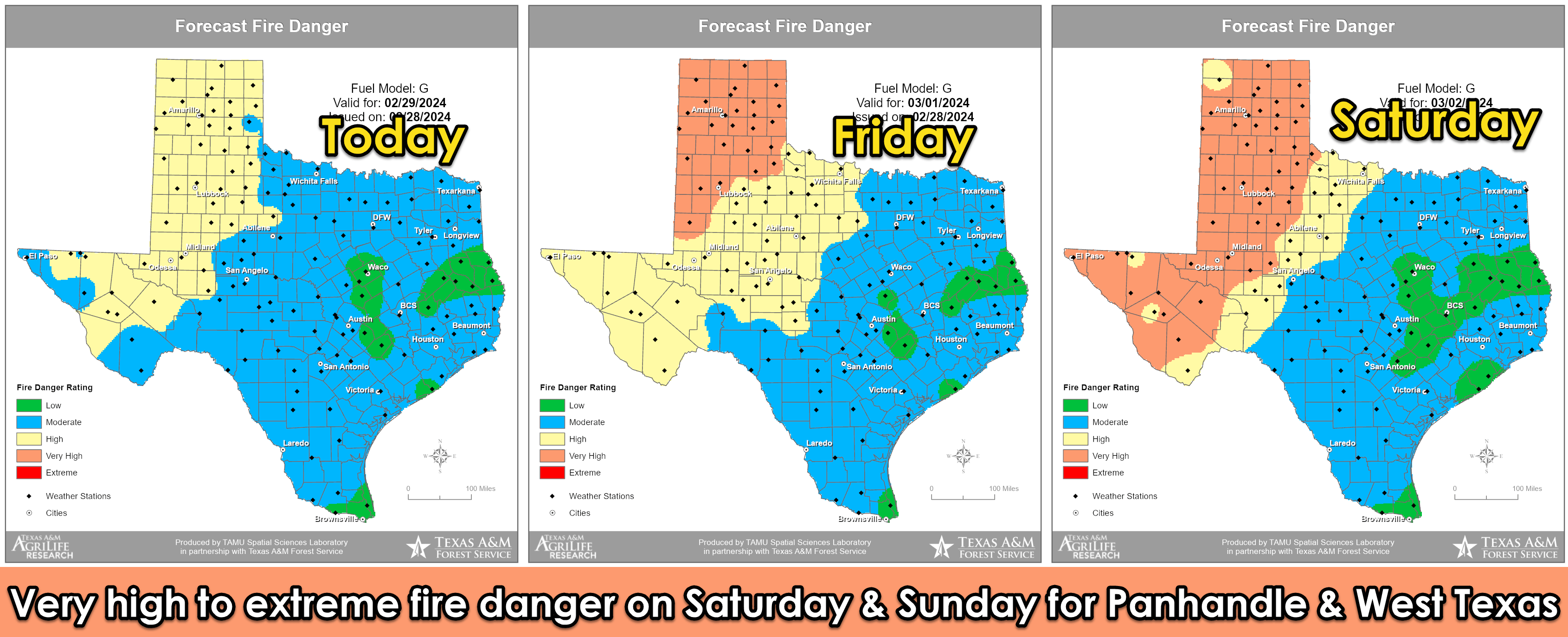
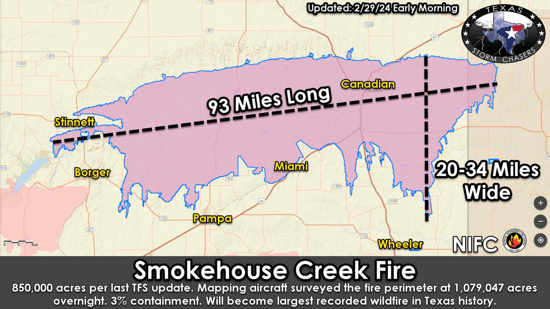
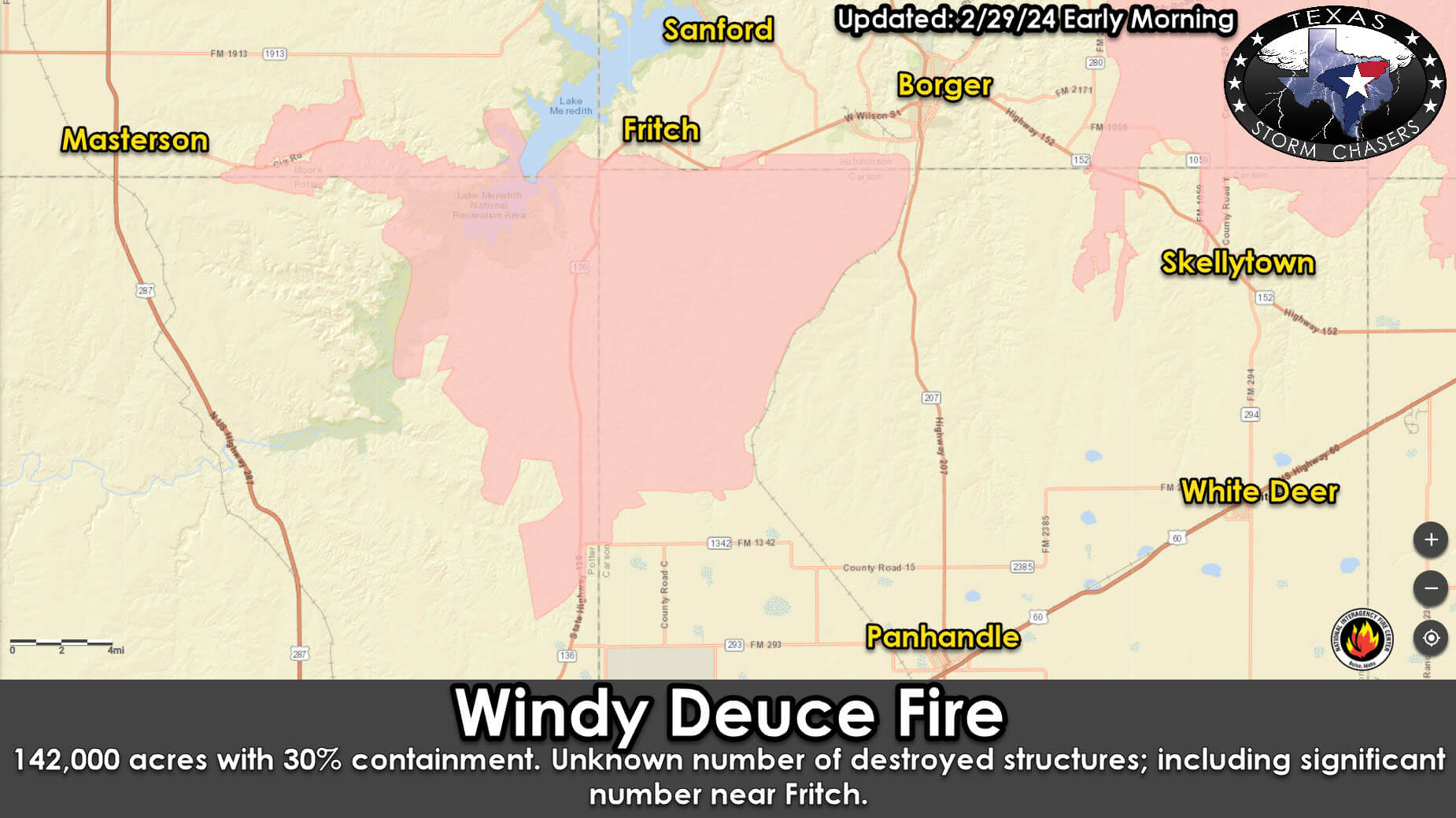
Warm temperatures, increasing south/southwesterly winds, and dropping humidity will bring fire danger back to the western third of Texas beginning tomorrow. These conditions will likely result in increasingly aggressive fire behavior with ongoing wildfires and any new fires. Critical to extreme wildfire danger will increase the threat of additional large wildfires on Saturday and Sunday across the western third of Texas. Ongoing fires will likely show substantial resistance to control; I cannot emphasize enough that we’re likely not done with the growing Smokehouse Creek Fire and the Windy Deuce Fire. They may not do much today or Friday, but we must watch them closely this weekend – especially the northern and eastern flanks. Any new fires have the potential to behave similarly. A cool front will bring a northerly wind shift to the Texas Panhandle sometime Sunday evening.
My FREE & AWESOME weather app for radar/alerts/more: https://texasweather.app/
The 24/7 Texas weather tracker & music: https://www.youtube.com/watch?v=lNZuPEWS5AI&t=0s
0 Comments