
Active weather returns to Texas on Thursday, with a conditional risk of severe storms, a few tornadoes, and the possibility of a bit of winter mischief. We’ll see mostly cloudy skies for most of Texas today and tonight. Late tonight, rain chances will increase across the Hill Country, Central Texas, and the Brazos Valley. Those rain chances will expand north into North Texas and Texoma on Thursday morning.
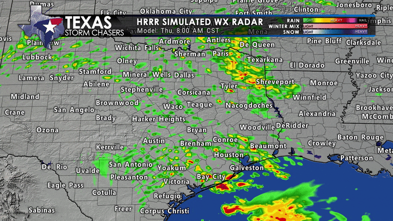
Mid-morning Thursday through Thursday evening will feature scattered to numerous showers and storms across the eastern third of Texas. Rain chances will conclude from west to east Thursday night into Friday morning. By the time all is said and done, we should see around one-half inch of rain along Interstate 35 from Texoma south through North Texas into South-Central Texas.
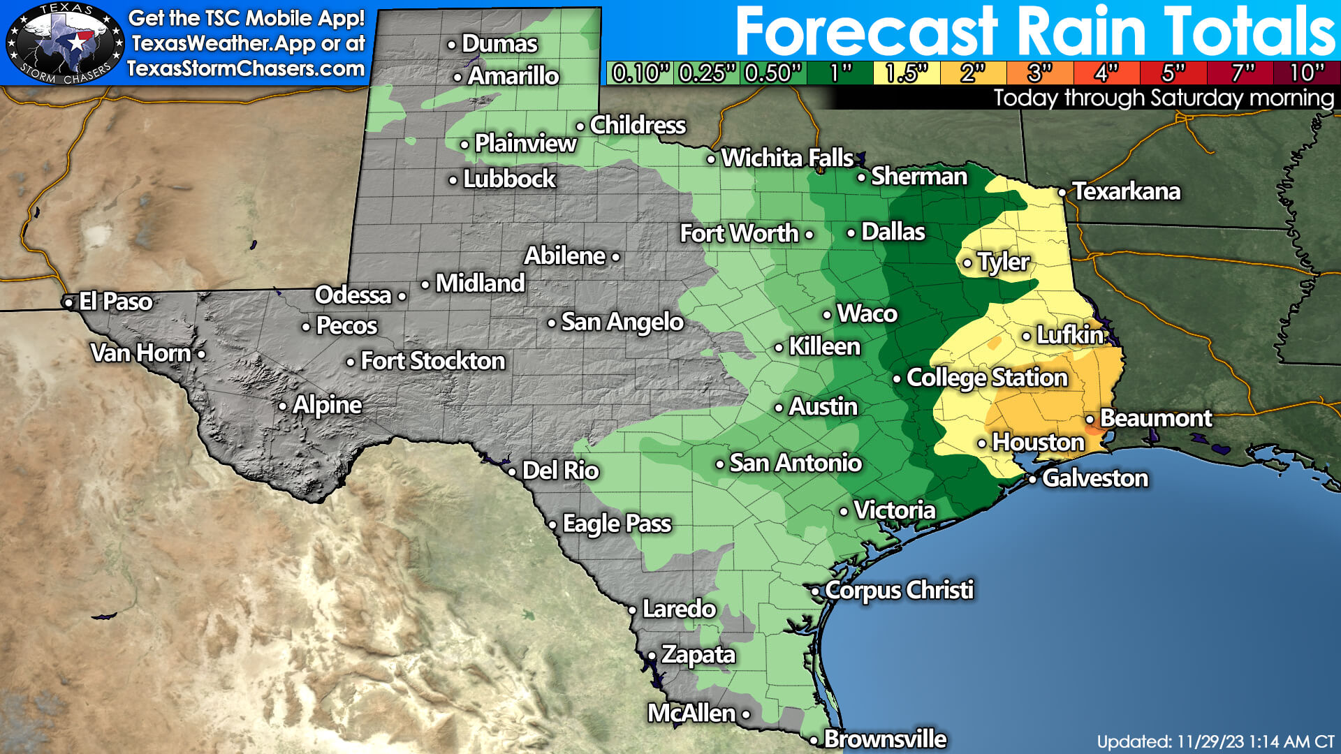
One to three inches of rain will be possible by Friday morning in the Ark-La-Tex, East Texas, down into the Golden Triangle. Localized, minor flooding may occur, but fast-moving storms should keep the overall flooding threat isolated. Showers are also expected in the Panhandle on Thursday afternoon. Very cold air aloft may allow some wet snow to mix in at times, but any accumulations should remain minor (dusting to one inch).
Thursday’s severe storm threat
As for the severe thunderstorm potential, we may be busy late Thursday morning through Thursday afternoon. The key word is *may*. Several ingredients will be in place, but questions remain that could limit the severe thunderstorm potential. We’ll talk more about those details in a bit.
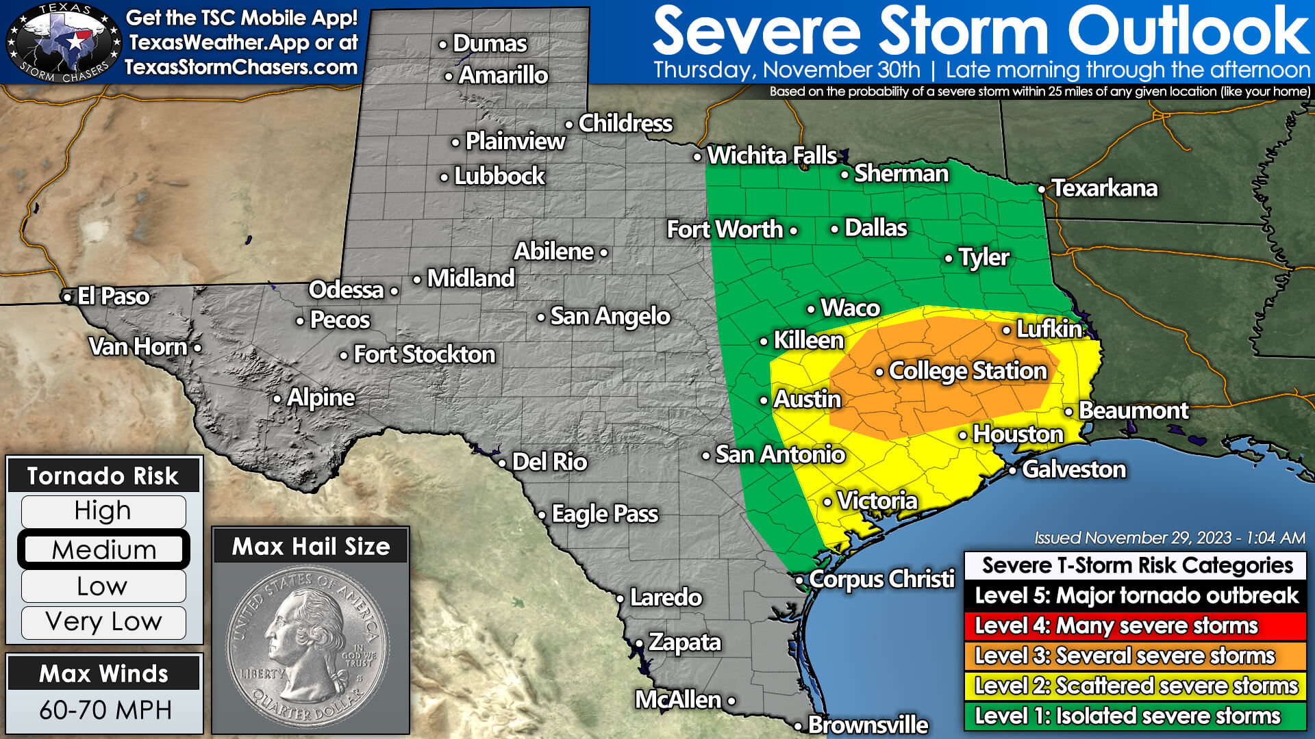
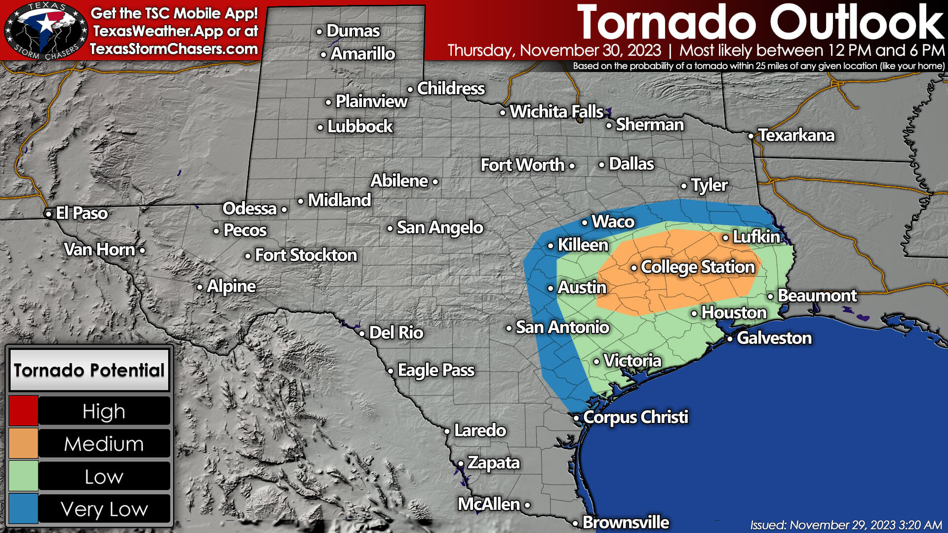
The Storm Prediction Center is highlighting the Brazos Valley, East Texas, the Coastal Plains, Southeast Texas, and the Golden Triangle for scattered severe thunderstorm potential late Thursday morning through Thursday afternoon. The primary severe weather threat looks to be tornado potential, though localized damaging wind gusts and hail are also possible.
As for Thursday’s severe weather setup: Strong wind shear in all levels of the atmosphere, increasing surface-dewpoint values, and upper-level lift will all be favorable for organized thunderstorms. What’s questionable is the amount of destabilization, given the possibility of numerous showers/storms. With the possibility of numerous showers/storms, we also have to consider the possibility that no individual storm will be able to ‘dominate’ the local environment – thus limiting the threat.
If the low levels of the atmosphere aren’t able to destabilize, that would also keep the severe weather threat lower. However, if we can see a few thunderstorms organized enough to become superceulluar with low-level destabilization, projected conditions would support the possibility of tornadoes. I’m giving you the ‘what ifs’ to show there are a few scenarios that could unfold tomorrow – with the potential we may see no tornadoes at all, or we may end up dealing with a situation like October 28, 2021, where we had tornadoes moving across Interstate 10 in the Golden Triangle.
Thursday’s severe weather setup certainly isn’t guaranteed, but there is concern we may have issues with a few storms. Even if we are dealing with tornadoes tomorrow, most thunderstorms will not be tornadic or even severe tomorrow. As always, if we do end up having to deal with tornadoes on Thursday, we’ll have live coverage on all of our social media outlets and on our website and mobile app. Chasers will be out as well to provide ground truth. Hopefully, we can get by with just a good rain without any spinny spinny doom doom mischief.
Friday through Sunday
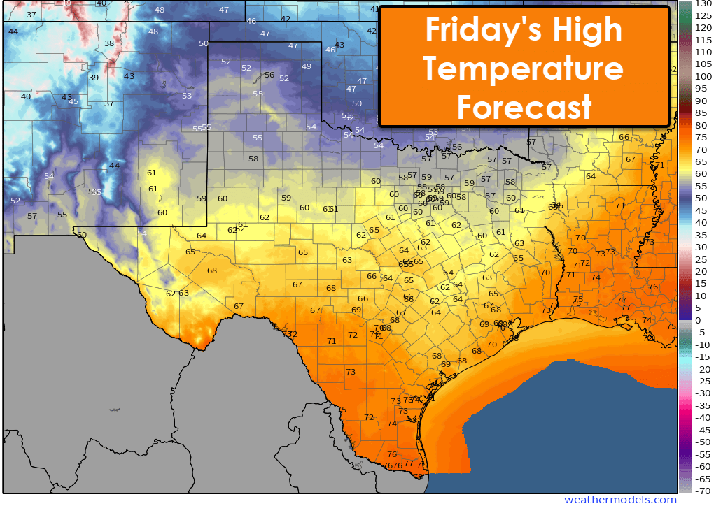
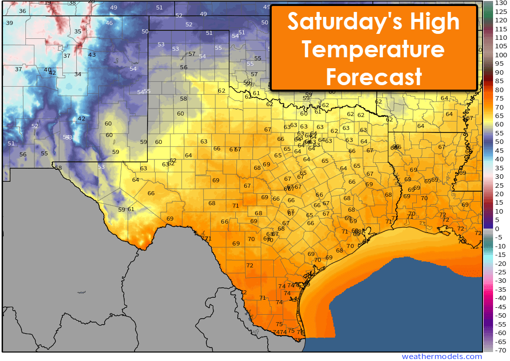
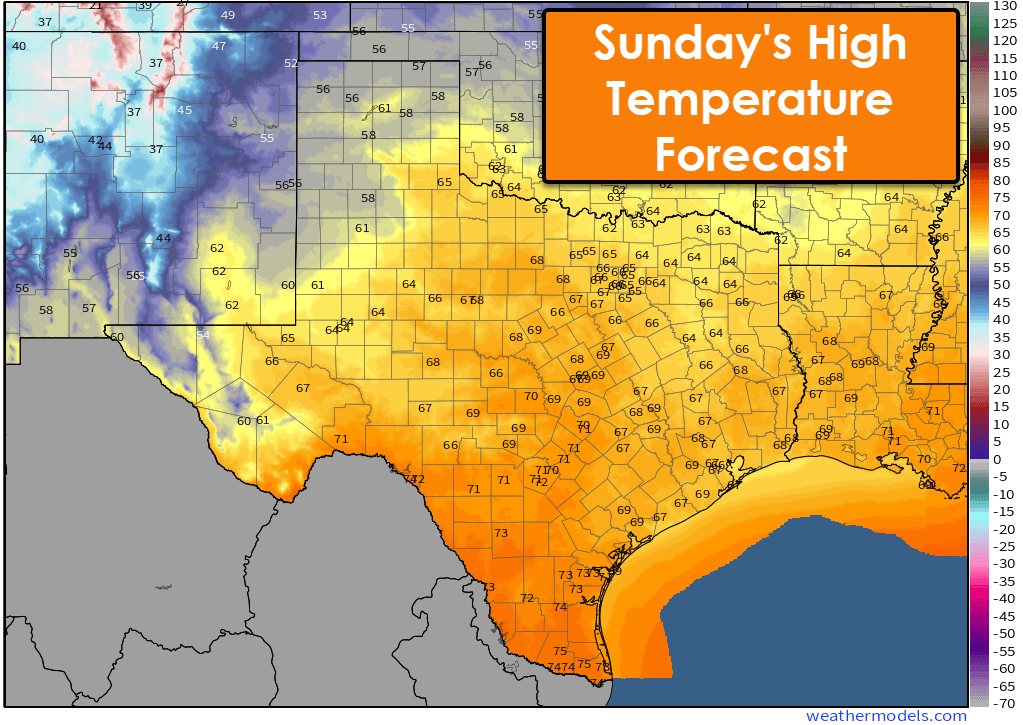
Friday through the weekend is looking mostly dry across Texas. A cool front will dip into the northern half of Texas for Friday with high temperatures in the 50s, but the southern half of Texas will top out in the 60s and 70s. For Saturday and Sunday, we’ll see high temperatures in the upper 50s through middle 70s across Texas—definitely not a bad way to start December.
Get the FREE Texas Storm Chasers Mobile App for your local weather forecast, interactive weather radars, live Texas weather coverage, and more! Available in your device’s app store.
Neli Castillo
Brenda Martinez 😱😱
Lauren Yowell 🤘🏻
Thank you for keeping us informed!
Can you write a note for my job saying I need to work from home on Thursday?
Annette Xiques
Kim Nichols
Catherine Collie
Taylor Chalk
Ian Sutton I’m putting my money on it all being east of us
Yeah most of it will. Bet we get some clouds and showers to
Taylor Chalk *tho
Ian Sutton sure hope so
JD Sledge 😐
C’mon rain. We need you. 78213
Latest technical discussion from TSC Meteorologist Trey Greenwood on tomorrow’s tornado potential: https://youtu.be/xCqN3vuPYLs
Krystal Williams
Thank you. Your explanation is much less doom and gloom than others. That gives me a tad bit of relief that a tornado isn’t coming straight for my living room 🙂
Cameron Hieb
How’s it looking in Dfw area tomorrow?
Golden triangle area??
Nope