
After a day of quiet and beautiful weather across Texas, we’re heading back into a busy weather pattern for the rest of the workweek. We’ll be dealing with another impressive upper-level storm system tonight and Wednesday morning. The second half of Wednesday and Thursday will feature a decaying eastern Pacific hurricane heading our way. Pamela will bring multiple rounds of heavy rain and storms to parts of Texas. We’re getting the moisture and perhaps a low tornado risk, not the other ‘hurricane’ hazards like storm surge or sustained high winds. It will not constantly be raining over the next several days – and even fewer folks will have to deal with a severe storm or flooding. Let’s talk about it!

A geographically sizeable severe weather risk exists today, tonight, into Wednesday morning. A level one risk for severe storms includes the Edwards Plateau, Concho Valley, Hill Country, Big Country, Central Texas, North Texas, Brazos Valley, and North Texas. This afternoon, those in Central Texas, the Brazos Valley, and North Texas could see isolated strong to marginally severe storms. Widespread severe weather is not expected.
We will need to keep an eye out if any very localized flooding threat develops in the Hill Country or Central Texas. Pocket-change size hail and gusty winds would be the primary concern with any stronger storms. Late tonight, after midnight and into the morning hours Wednesday, we may see storms in northern Mexico move into the Edwards Plateau and South-Central Texas. Hail and strong winds may occur with stronger storms – plus very heavy rainfall.
Timing/Hazards

Our primary severe weather threat will occur after sunset in the eastern third of the Texas Panhandle. Much like the storms late Sunday in North Texas, we’re not expecting any activity to develop until strong upper-level lift arrives near the dryline’s location. Timing is about 7-10 PM for rapid thunderstorm development across the eastern half or eastern third of the Texas Panhandle. Hopefully, storms will grow upscale into a squall line quickly.
Initial discrete or semi-discrete storms may become supercelluar with a risk of damaging hail, destructive straight-line winds, and at least a low tornado threat. Low-level wind shear will be very favorable for tornadoes, so if we have discrete storms, we’re going to have problems.
Storms in a squall line (linear mode) would still produce shorter-lived tornadoes, damaging straight-line winds and hail. Storm movement will be off to the north/northeast at 50 MPH (so they’ll be booking it) toward Western Oklahoma and the eastern Oklahoma Panhandle. The scenario mentioned above would occur between about 8 or 9 PM through 1 AM. Storms should be exiting the Texas and Oklahoma Panhandles into Western Oklahoma by 1 or 2 AM Thursday.
We may also see a few storms try to fire up late this afternoon in Northwest Texas/Southwest Oklahoma. If those storms develop, they’d rapidly move northeast. It is a low probability scenario, but one that would support a supercelluar storm mode with severe weather hazards – including tornadoes.
Scattered thunderstorms are also possible late tonight and into the morning hours on Wednesday in the Big Country, Concho Valley, and Edwards Plateau. We can’t rule out stronger storms or localized flooding.
Hurricane Pamela’s remnants heading to Texas late Wednesday & Thursday
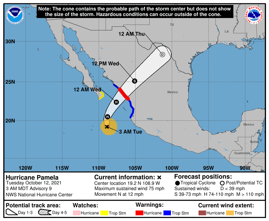
Eastern Pacific Hurricanes can often influence our weather in the Lone Star State. When those hurricanes make landfall in Baja California or western Mexico, their moisture is frequently pulled northeastward into our neck of the woods. That’ll be the case as we head into late Wednesday and Thursday. Pamela itself became a hurricane this morning and will make landfall Wednesday morning in West-Central Mexico. Rapid weakening is likely after landfall, but Pamela may still have some semblance of organization on Thursday when it moves into Texas. I’m not talking about sustained tropical-storm-force winds or a storm surge, but it may still have a decent ‘swirl’ to it.
Heavy Rain to lead to flash flooding issues
An axis of heavy rainfall and flooding is becoming increasingly likely Wednesday Night and Thursday as Pamela heads into our region. We’ll deal with an axis of heavier rains extending from the Edwards Plateau northeastward into the eastern Concho Valley, Hill Country, North Texas, and Texoma. The axis may still shift some to the west or the east in future forecasts – it’s all dependent on Pamela’s track.
The Weather Prediction Center is already highlighting an increased flash flood risk on Wednesday, Wednesday Night, and Thursday in those regions. Not everyone will receive significant rains or flash flooding. However, the upcoming weather pattern does have similarities to past events that have produced substantial flooding in portions of Texas. Heightened awareness is recommended on Wednesday and Thursday for those in the regions described above – especially if you’re traveling or reside in an area that is susceptible to flooding.
The D/FW Metroplex, Waco, Austin, San Antonio, Eagle Pass, and Del Rio urban centers are in the zones with increased risks for significant flash flooding potential. That doesn’t mean all of those cities will have to deal with flooding. More heavy rainfall and additional flash flooding may occur on Thursday across Texoma, North Texas, Central Texas, the Brazos Valley, and the Hill Country.
Overall Forecast Rain Totals through Saturday
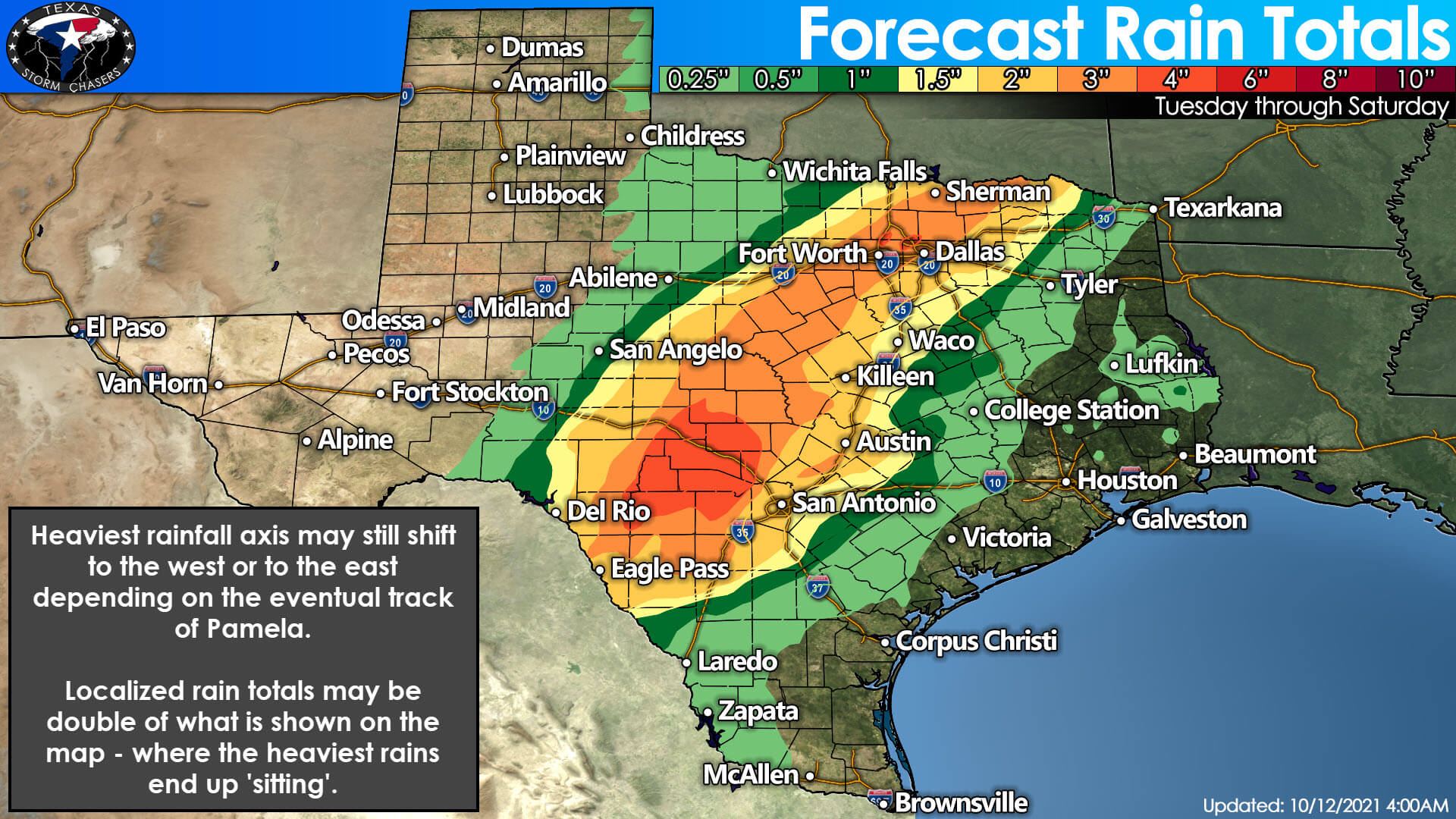
Here is the latest rain total forecast from the Weather Prediction Center. We’re looking at widespread three to five-inch rainfall amounts from the Edwards Plateau (Del Rio and Eagle Pass) northeast through the eastern Concho Valley, South-Central Texas, and Hill Country up through North Texas and Texoma. Those higher rain totals include the San Antonio Metro, Austin, the D/FW Metroplex, and Sherman.
Some shifts west or east are probable, depending on the eventual track of Pamela. Localized rain totals could be double what is shown on the map – with a few unlucky folks receive seven to ten inches of rain. Rainfall amounts fall off drastically to the west and the east of the ‘moisture train.’ There will be a sharp cutoff from multi-inch rains to barely one-quarter inch.
A low threat for brief tornadoes and localized damaging winds may develop Wednesday Night and Thursday Morning in the Edwards Plateau, Hill Country, and South-Central Texas. The threat is expected to be much more limited/isolated than the heavy rain and flooding issues.

Chance of precipitation Wednesday through Saturday across Texas
Tonight’s Storm Chasing & Live Coverage Plans
Some TSC crew will be chasing in the eastern Texas Panhandle or western/northwestern Oklahoma tonight. Data willing, they’ll have live streaming storm chase video available on our YouTube channel and here on the website/app. Even I may venture out if the Northwest Texas/Southwest Oklahoma play becomes more likely. Otherwise, I do plan on providing severe weather coverage tonight for the eastern Texas Panhandle. If the threats warrant – I’ll also provide live severe weather coverage for the eastern Oklahoma Panhandle and Western Oklahoma. We haven’t done that before, but I know we have plenty of fans in those parts.


0 Comments