
A strong cold front is in the process of pushing south across West Texas and Texoma this morning. Strong north winds up to 50 miles per hour produce wind chills in the 20s across the Panhandle. Some folks in the Panhandle even saw a few snowflakes overnight. There will be no accumulating winter precipitation in Texas today.
The fact I’m talking about snow in Texas as we head in the second to the final week of April is on the absurd side. We’re also at a big zero for Texas tornadoes this month (April). We’ve been lucky in the tornado department, but hailers have caused enough problems. We will not be dealing with any severe thunderstorms today. There will be a significant temperature drop along with strong north winds behind the cold front.
Late season frost/freeze for northern half of Texas tonight
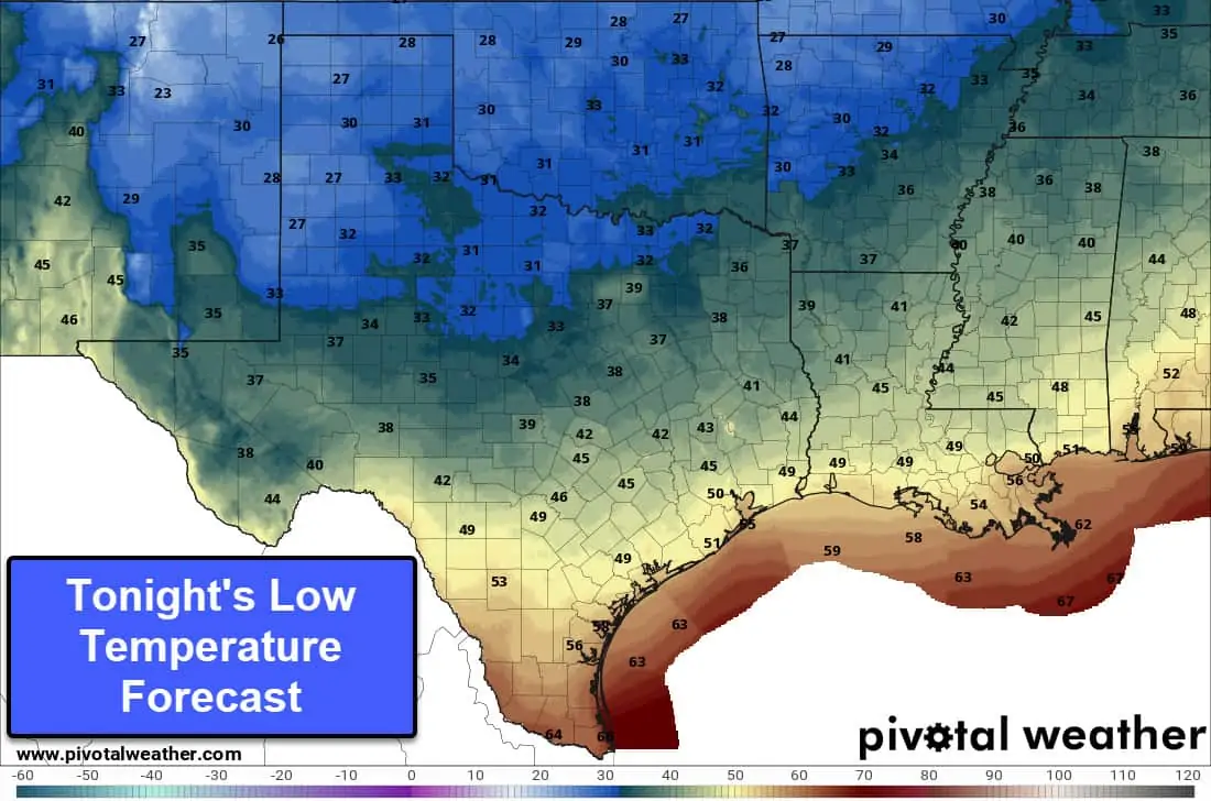
Tonight’s Low Temperature Forecast
Crashy the cold front is bringing an unseasonably late surge of arctic air into the Southern Plains. A late-season freeze will be adding to the woes farmers have dealt with since last fall. A freeze is in the forecast tonight across the Texas Panhandle, West Texas, Northwest Texas, and Texoma. Sheltered or relatively low-lying locations in the Big Country, Hill Country, North Texas, and Northeast Texas may receive a freeze tonight. Frost will be possible in the northwestern half of Texas tonight – so it would be wise to cover or bring in sensitive plants. Some towns will tie or set new record low temperatures tonight. This is not a repeat of February’s arctic outbreak in duration or intensity. The southeastern half of Texas will remain on the warm side of the front through tonight.
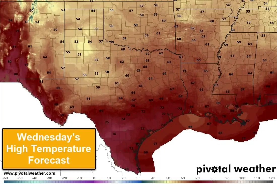
Wednesday’s High Temperature Forecast
The cool front should be through the northwestern half of Texas by sunrise Wednesday. Depending on where the front stalls out tomorrow, some folks may end up starting the day in the 70s and drop once the front passes. High temperatures will top out in the 50s and the 60s across the northern half of Texas. Definitely on the cooler side for April, but again – not even remotely comparable to February. Those with agricultural interests will mainly feel the cold weather impacts. There are no crazy winter storms, no prolonged sub-freezing airmass, and with a little bit of luck, perhaps we won’t have a power grid failure. Folks won’t be able to blame wind turbines this time.
Spring storms return on Friday
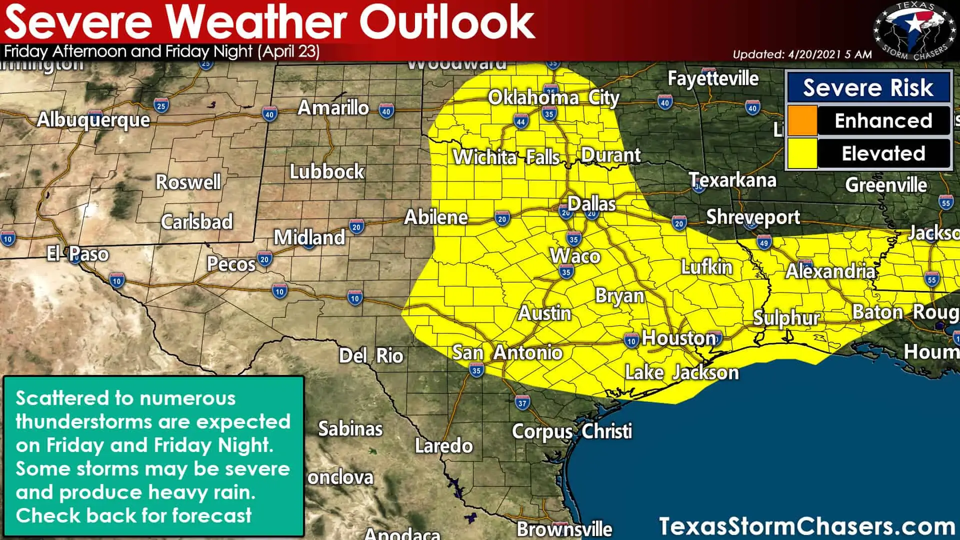
Thunderstorms will return to the eastern two-thirds of Texas on Friday. Some storms may be severe with heavy rainfall.
A rapid air mass modification will begin Wednesday night and Thursday as southerly winds return and moisture starts flowing north. By Friday, we’ll be back to typical spring-time weather – both in temperatures and with the chance for severe thunderstorms. Scattered to numerous thunderstorms are expected on Friday and Friday Night across the eastern two-thirds of Texas. Locally heavy rainfall and a few severe thunderstorms will be possible. We’ll refine specific threats and timing once we get closer to the end of the workweek. Saturday afternoon through Sunday look nice in the weather department.
For what it’s worth, long-range weather model guidance shows another chance of severe weather around Tuesday of next week.


0 Comments