
Winter Storm Watches or Winter Storm Warnings are in effect for nearly all of Texas. Technically, they include at least a portion of all 254 counties in the state. However, the watch technically does not yet include the city of El Paso.
For simplicity and for the fact I’ve been running on little sleep for days, we’ll go ahead and say the entire state. Those within a winter storm watch will likely be upgraded to a winter weather advisory or winter storm warning later today. Those upgrades occur when we’re within 24-36 hours of the event.
Don’t get hung up on the terminology of what ‘winter weather’ alert affects your location. The bottom line is we’re expecting accumulating winter precipitation and brutally cold weather across all of Texas over the next several days. Another significant winter storm is on the table for Tuesday Night and Wednesday.
Before you dive into my novel of a blog post, I want to share a few essential links that might come in handy.
Texas Road Conditions can be found at https://drivetexas.org.
You can track the incoming winter weather with our interactive weather radar (here). Those using our free mobile app can click the ‘radar’ button in the bottom menu.
Speaking of the TSC mobile app, you can get our latest blog posts sent directly to your phone. Download the free TSC mobile app here.
Forecast Snow & Ice Accumulations
Before we get into the timing, let’s talk accumulations. We continue to forecast accumulating snow for the northwestern two-thirds of Texas late tonight, Sunday, and Monday morning. I don’t want to get hung up on specific totals because, frankly, it won’t matter when it comes to travel impacts.
Temperatures are frigid and will stay below freezing for a long time yet. Whatever falls from the sky will stick to roads without issue. Our upcoming winter storm won’t be a typical ‘Texas winter storm’ where we see roads clear up hours after the snow stops.
This will be like a snow storm up in Minnesota or the Northeast US – except we have a fraction of the snow clearing equipment those states do. That’s not a knock against TxDOT – it is merely the fact we haven’t had a winter storm hitting all 254 counties in Texas simultaneously in decades.
Major highways may start improving on Tuesday, but most residential streets and non-snow routes won’t. That’s not to mention the little detail of another significant winter storm dropping more winter weather on top Tuesday Night and Wednesday.
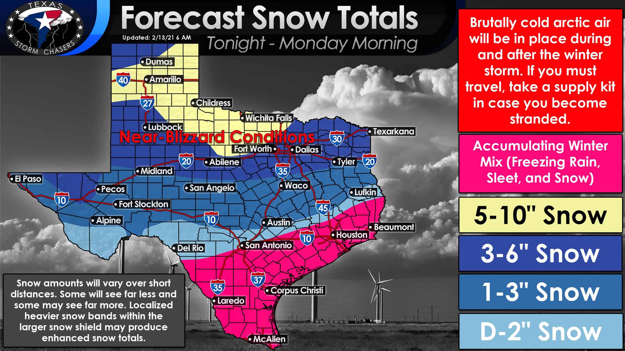
Forecast snow accumulations as of 6 AM Saturday. Click the image for a full-size version.
Snow is likely to be the primary precipitation type across the northwestern two-thirds of Texas. Accumulating snow of one to two inches is forecast north of a line roughly from Del Rio to San Antonio to Brenham to Jasper. Some sleet and freezing rain may also accumulate in those areas, making for one nasty winter mess.
Snow totals will increase the farther north you go, with several inches of snow across Texas’s northern half. Near-blizzard conditions with blowing snow and visibilities below one-quarter mile are expected, especially across the northern third of Texas, where snow accumulations will range from five to ten inches. Gusty north winds will result in wind chills well below zero.
Specific snow totals will probably change and shift some as we can pin down where localized, heavy bands of snow may form within the larger precipitation shield. South of the ‘snow zone’ will be our ‘wintery mix of doom’ zone, where freezing rain, sleet, and snow will combine to make an icy nightmare.
Ice accumulations could range from a few hundredths of an inch up to three-tenths of an inch. A dusting to one inch of snow may occur in addition to the ice, especially along and north of Interstate 10.
It’ll only take a glaze of ice to turn bridges and overpasses into skating rinks. That is the Houston Metro’s expectation by Sunday afternoon, and that’ll continue through at least Monday. This winter weather event will be so widespread that it doesn’t make much sense for me to ‘narrow down’ impact zones.
Any location in the State of Texas could experience winter precipitation by Sunday Night. Even the Rio Grande Valley (Brownsville) could see some ice accumulations on elevated objects.
Ice is probably more dangerous than snow in the fact it can sneak up on you and turn what appears to be a ‘wet’ road into a skating rink. Sadly, we’ve seen that many times this week. We’ll keep an eye out to try and pinpoint areas that may end up with more than one-quarter inch of ice.
While a trace of freezing rain can ice up roads, a quarter-inch of ice (or more) can start taking down trees and power lines.
Winter Weather Timing
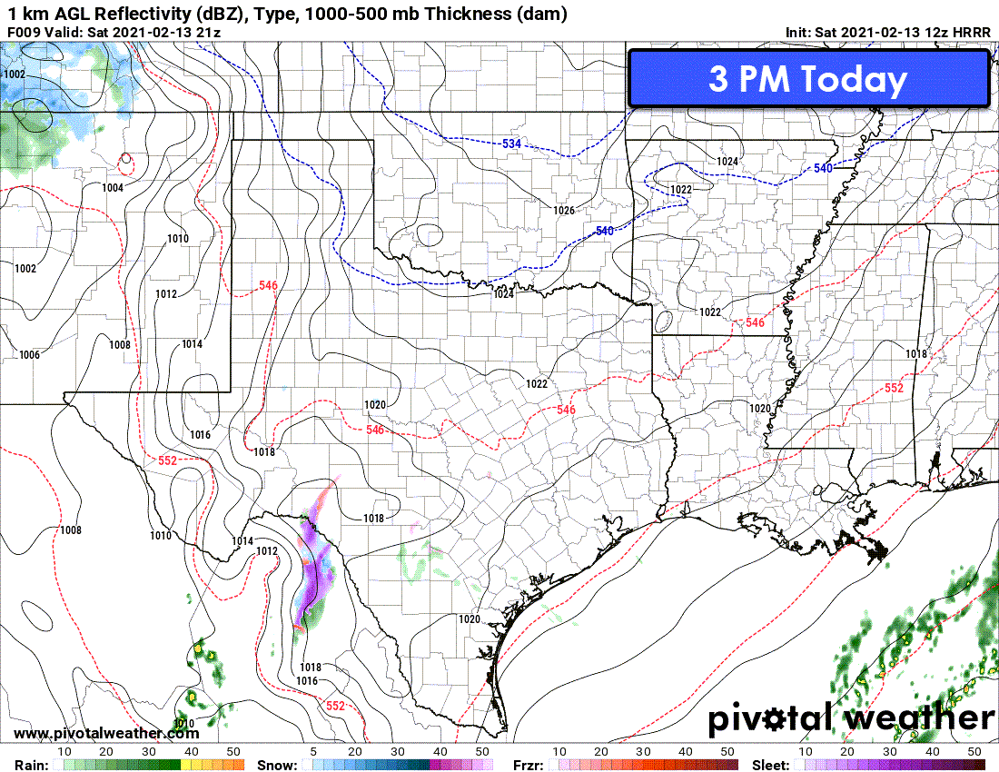
Simulated weather radar from the 6 AM High Resolution Rapid Refresh. This is only one model and one run of that one model. Don’t expect this simulation to correctly depict exactly how this winter weather event will unfold. It is a good model, but it is not a perfect model.
The timing was moved up about six hours compared to our forecasts yesterday. We’ll be dealing with two upper-level storm systems over the next few days. The second one is the big winter storm that’ll ramp up late tonight and tomorrow.
Our first upper-level storm is weaker but strong enough to produce winter precipitation. Freezing drizzle, freezing rain, and sleet may occur this afternoon and ramp up tonight through Sunday morning across the Concho Valley, Hill Country, Central Texas, Brazos Valley, and East Texas.
Snow is possible in the Big Country, North Texas, and Northeast Texas tonight. Overall accumulations of all precipitation types should remain comparatively light (at least when looking at it next to the second system).
However, ice and snow accumulations are likely going to be enough to make roads slick and hazardous. When roads go downhill tonight, those untreated roads will probably stay that way through at least Tuesday – or even Thursday for some.
Snow will increase after dinner-time in the Texas Panhandle, West Texas, down into the Guadalupe Mountains. Light to moderate snow will move into Northwest Texas after midnight and expand into the Big Country, Permian Basin, Concho Valley, and Southwest Texas tomorrow morning.
Snow should be moving into North Texas, including the D/FW Metroplex, by noon Sunday. A full-on winter mess will be unfolding by late Sunday afternoon across the western two-thirds of Texas and into South-Central Texas and the Brazos Valley.
Assuming surface temperatures can make it a bit above freezing in Southeast Texas and the Coastal Plains tomorrow, we’ll start with rain. However, that’ll switch over to winter precipitation not long after sunset Sunday.
Moderate to heavy snow will be underway tomorrow evening across North Texas, Northeast Texas, Central Texas, the Hill Country, and into the Edwards Plateau. Freezing rain, sleet, and maybe some snow mixed in will be underway across Southeast Texas, the Coastal Plains, Southeast Texas, and the Middle Texas Coast.
The freezing line, thus the change over from rain to freezing rain, won’t be too far north of Zapata and the McAllen/Brownsville metros. Those cities should have freezing rain, maybe mixed with some sleet, not long after midnight Monday for a few hours before precipitation in South Texas concludes. Snow, sleet, and freezing rain will continue moving eastward across the eastern third of Texas late Sunday and during the pre-dawn hours Monday.
I’m hoping we’ll have precipitation ending in Northeast Texas, East Texas, and the Golden Triangle (Far Southeast Texas) by lunch-time Monday. Temperatures across much of Texas will remain well below freezing on Monday as brutally cold arctic air moves south on the backside of the departing upper-level storm system.
That’ll set the stage for some of the most frigid temperatures some Texas cities have seen in decades by Tuesday morning. Monday afternoon through Tuesday afternoon should feature mostly dry weather across Texas.
Colder than a skinny dip in Lake Michigan
It’ll be colder than a skinny dip in Lake Michigan in January, but at least it’ll be dry. For the northern seventy-five percent of Texas, the only way roads will improve on Monday or Tuesday is when they get plowed or sanded. Even then, that’s only likely to occur on highways and busier city arteries. Residential streets and secondary roads will likely remain hazardous.
Another Winter Storm | Tuesday Night and Wednesday
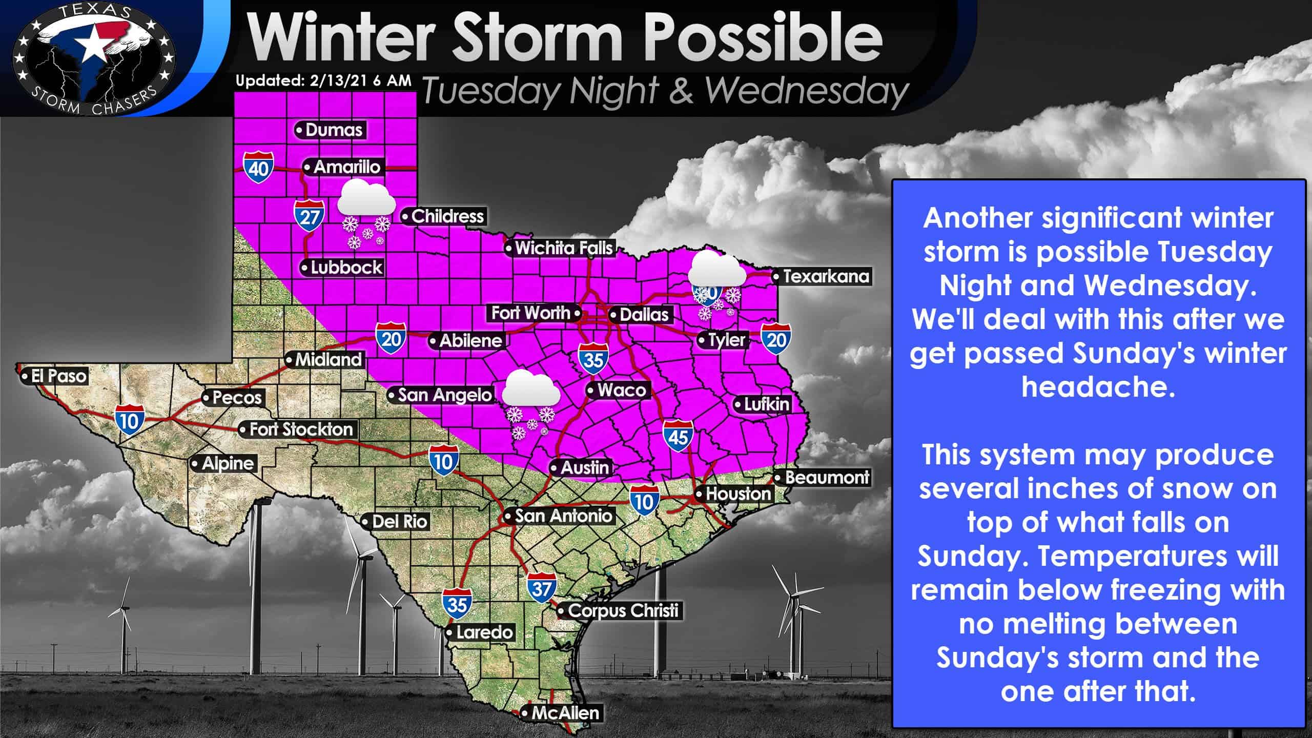
Another significant winter storm is possible Tuesday night and Wednesday. Click the image for a full-screen view.
But wait! There’s more! Another robust upper-level storm system will move across Texas Tuesday night and Wednesday. With an arctic air mass still in place, another significant winter storm is possible for Texas’s northern half. We’ll have to see how far south the freezing line still is by that point to assess the potential for a winter mix farther south.
Several inches of snow is possible on top of what we have fallen on Sunday and Monday. The Tuesday Night/Wednesday system could be the wetter one with more moisture to work with. That could mean more in the way of winter precipitation and perhaps wetter snow (which would be problematic for areas that end up with over a foot of snow combined from both events).
We’ll deal with the mid-week system after we get past tomorrow.
Finally, the conclusion.
It looks like we’ll be dry for a while and start climbing the temperature roller coaster after Wednesday. That being said, until the snowpack melts, we’re going to have a hard time climbing that temperature roller coaster. I expect those without snow cover may end up being 30 degrees warmer than their neighbors who still have snow on the ground by Friday and the weekend.


0 Comments