

Simulated weather model radar from the High-Resolution Rapid Refresh (HRRR). All images may be enlarged by clicking/tapping on them.
We’re starting Hump Day with a rain shield moving northeast across the Concho Valley and Hill Country. Light to moderate rainfall will continue moving northeast through the afternoon hours. Scattered showers will continue this evening through Thursday morning across the Trans-Pecos, Southwest Texas, the Concho Valley, Big Country, and North Texas. We do not anticipate any severe thunderstorm or flooding threat with a stable air mass in place today.

January chill will be the name of the game today, where rain and cloud cover keeps temperatures from rising much. Outside of the rain, temperatures will be pretty darn lovely across the Panhandles and the Rio Grande Valley, Coastal Plains, and Southeast Texas. It may be cloudy, but at least it’ll be warm.

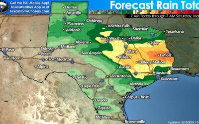
Forecast rain totals from today (Wednesday) through Saturday morning. This map covers the first storm system, which should be departing late Friday. Flooding is not expected to become a significant issue.
I am happy to report much-needed rain is expected to fall in areas that need it over the next couple of days. One quarter to one-half inch of rain is expected across the higher terrain of Southwest Texas northeastward to San Angelo and Abilene. We’ll also see a corridor of higher rainfall totals up to one-inch by Friday across East Texas. The anticipated rainfall totals through Friday should not result in much of a flooding threat. Saturday looks to be a ‘down day’ while Texas is in-between upper-level storm systems.
Storm System #2 (Sunday & Monday)
A more robust upper-level storm system is expected to arrive on Sunday. Rain chances will quickly rise again on Sunday and Sunday Night across the eastern half of Texas. We’ll have to see where the upper-level dynamics set-up shop along with a developing surface low pressure. Some heavy rainfall is possible across the ArkLaTex and East Texas. The overall potential of severe thunderstorms remains unclear at this time. Still, it will be monitored as we get closer to Sunday.

Potential rain totals with the Sunday-Monday storm system. As one might expect with a forecast five days out, we’ll likely see adjustments in future updates.
Timing differences amongst various weather models aside, we should see a calm weather stretch by late Monday and Tuesday. An unsettled weather pattern will continue next week, with the potential for upper-level storm systems every few days.
0 Comments