
National Weather Service crews have been busy the last several days conducting ground surveys. Those crews from three separate offices have confirmed a total of ten tornado tracks from the January 10th severe weather event. All ten tornadoes were classified as ‘weak’ with estimated peak winds between 75 MPH and 110 MPH. While categorized as ‘weak,’ any tornado can still cause significant damage. In this case, one fatality was reported due to trees falling on a home. While not given the ‘fame’ of a tornado, many areas of South-Central Texas, the Brazos Valley, Southeast Texas, eastern North Texas, and East Texas reported damage from straight-line winds. These areas of straight-line winds produced damage similar to that seen from weak tornadoes. That’s why we were emphasizing the need to take Friday’s storms seriously in East Texas. It does not matter if winds are ‘straight-line’ or tornadic; they can produce similar damage and pose a threat to lives.
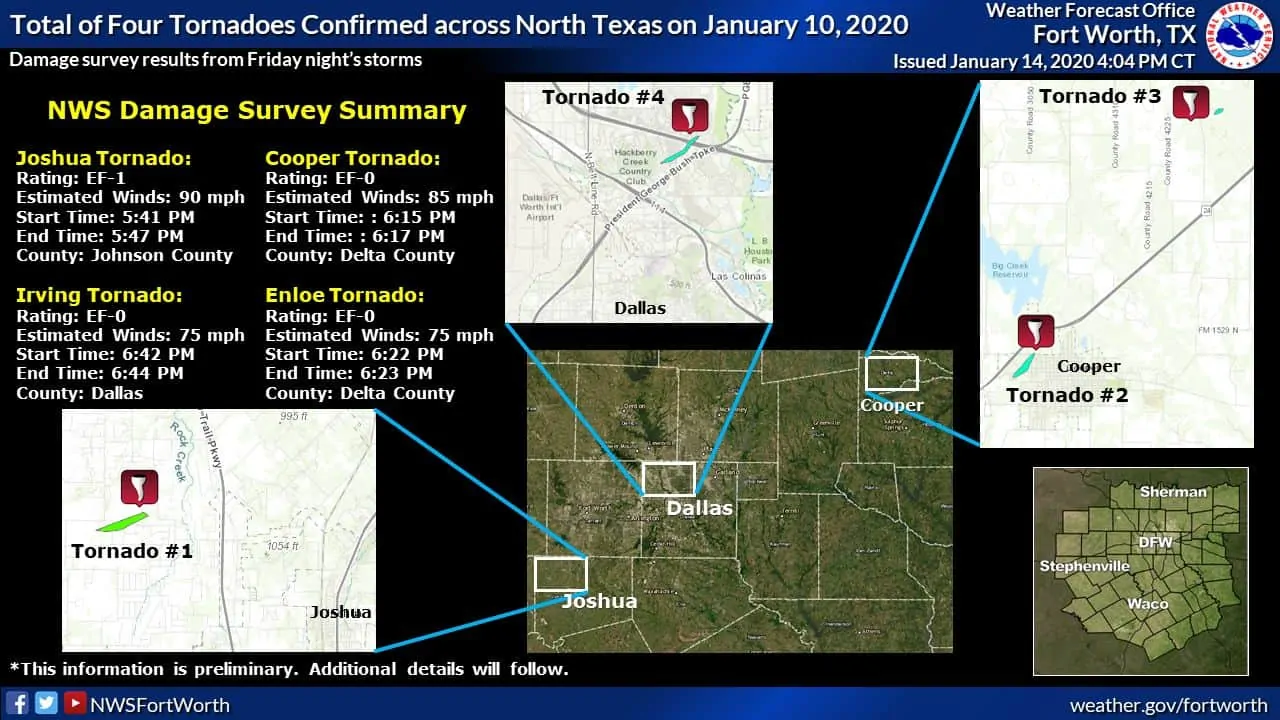
Tornado #1: Johnson County/Joshua Tornado
Rating: EF1
Estimated Peak Wind: 90 mph
Path Length /statute/: 1.06 miles
Path Width /maximum/: 250.0 yards
Fatalities: 0
Injuries: 0
Start Date: 01/10/2020
Start Time: 05:41 PM CST
Start Location: 4 NE Godley / Johnson County / TX
Start Lat/Lon: 32.4886 / -97.4673
End Date: 01/10/2020
End Time: 05:47 PM CST
End Location: 4 WNW Joshua / Johnson County / TX
End Lat/Lon: 32.4934 / -97.4502
Survey Summary:
The tornado began at approximately 5:41 PM CST in an open field
west of CR-913A and damaged several homes and buildings near
Piester and CR-913A. A barn was flipped and came to rest on the
side of a house. Several homes in the area had damaged roofs
and/or collapsed attached awnings. A large horse trailer was moved
and an 18 wheeler trailer was overturned. A small 5 ft by 6 ft
storage shed was damaged as well as 4 power poles leaning 10-15
degrees. Just northeast of this area, several homes near the end
of Dove Meadow Lane sustained minor damage. Shingles were removed
from homes and sheds were damaged. The tornado dissipated before
reaching FM 1014.
Tornado #2: Cooper Tornado
Rating: EF0
Estimated Peak Wind: 85 mph
Path Length /statute/: 0.45 miles
Path Width /maximum/: 150.0 yards
Fatalities: 0
Injuries: 0
Start Date: 01/10/2020
Start Time: 06:15 PM CST
Start Location: 1 W Cooper / Delta County / TX
Start Lat/Lon: 33.3727 / -95.7016
End Date: 01/10/2020
End Time: 06:17 PM CST
End Location: 1 NW Cooper / Delta County / TX
End Lat/Lon: 33.3776 / -95.6965
Survey Summary:
A small supercell thunderstorm moved northeast into Delta County,
Texas, spawning a brief tornado on the west side of the City of
Cooper. The tornado formed about two blocks south of West Dallas
Avenue in west Cooper, destroying a small outbuilding and causing
minor roof and tree damage. The tornado moved northeast, crossing
Dallas Avenue and pulling the roof and an exterior cinder block
wall off of a small commercial building. Exterior siding damage
also occurred to a two-story apartment complex nearby. The tornado
continued toward the northeast, seriously damaging a large sheet
metal cotton gin building. Minor tree and structural damage
continued for approximately another 200 yards before the tornado
dissipated south of State Highway 24.
Tornado #3: Enloe Tornado
Rating: EF0
Estimated Peak Wind: 75 mph
Path Length /statute/: 0.15 miles
Path Width /maximum/: 100.0 yards
Fatalities: 0
Injuries: 0
Start Date: 01/10/2020
Start Time: 06:22 PM CST
Start Location: 4 NNE Cooper / Delta County / TX
Start Lat/Lon: 33.4254 / -95.6532
End Date: 01/10/2020
End Time: 06:23 PM CST
End Location: 4 NNE Cooper / Delta County / TX
End Lat/Lon: 33.4265 / -95.6513
Survey Summary:
The same supercell that produced the Cooper tornado moved
northeast about 4 miles and spawned a second very brief tornado
near Enloe, in northern Delta County. The tornado touched down in
an open field just southeast of Enloe, destroying a couple of
small outbuildings and scattering the debris downwind a few
hundred yards. The debris pattern exhibited a subtle cyclonic
orientation, implying a brief, weak tornado.
Tornado #4: Irving Tornado
Rating: EF0
Estimated Peak Wind: 75 mph
Path Length /statute/: 1.11 miles
Path Width /maximum/: 175.0 yards
Fatalities: 0
Injuries: 0
Start Date: 01/10/2020
Start Time: 06:42 PM CST
Start Location: 3 N Irving / Dallas County / TX
Start Lat/Lon: 32.9067 / -96.9645
End Date: 01/10/2020
End Time: 06:44 PM CST
End Location: 4 SE Coppell / Dallas County / TX
End Lat/Lon: 32.9161 / -96.9492
Survey Summary:
A tornado formed along the eastern edge of the Hackberry Creek
neighborhood, near the intersection of Kinwest Parkway and
Parkridge Boulevard. Minor roof and tree damage was observed in
this area. The tornado moved quickly toward the northeast,
producing roof damage to a grocery store and nearby trees,
lightpoles, and commercial signage near the intersection of North
MacArthur Boulevard and Las Colinas Boulevard. Continuing
northeast, exterior wall damage occurred at a nearby hotel, and
window and roofing damage impacted two restaurants fronting
Interstate 635. The tornado crossed the Interstate and produced
minor tree and roof damage before dissipating near Ranchview
Drive.
Tornado #5: Caldwell Tornado
Rating: EF1
Estimated Peak Wind: 100 mph
Path Length /statute/: 0.11 miles
Path Width /maximum/: 100.0 yards
Fatalities: 0
Injuries: 0
Start Date: 01/10/2020
Start Time: 09:34 PM CST
Start Location: 6 WSW Caldwell / Burleson County / TX
Start Lat/Lon: 30.4847 / -96.8042
End Date: 01/10/2020
End Time: 09:35 PM CST
End Location: 6 WSW Caldwell / Burleson County / TX
End Lat/Lon: 30.4861 / -96.8034
Survey Summary:
Shed destroyed. Numerous trees snapped. Trailer thrown southward
around 40 yards. Other debris thrown toward the northeast.
Tornado #6: North of Rusk in Cherokee County
Rating: EF1
Estimated Peak Wind: 105 mph
Path Length /statute/: 0.86 miles
Path Width /maximum/: 75.0 yards
Fatalities: 0
Injuries: 0
Start Date: 01/10/2020
Start Time: 11:21 PM CST
Start Location: 2 NW Rusk / Cherokee County / TX
Start Lat/Lon: 31.8177 / -95.1751
End Date: 01/10/2020
End Time: 11:22 PM CST
End Location: 2 NNW Rusk / Cherokee County / TX
End Lat/Lon: 31.825 / -95.1646
Summary: Tornado first touched down on a farm off of County Road
1619, uprooting trees in a convergent pattern. It also broke
windows and partially damaged the roof of a home before it
destroyed a shed and damaged the roofs of two more homes. The
tornado crossed Route 69 and went on to uproot trees and damage
the roofs of two more homes before lifting.
A special thanks goes out to the Cherokee County Emergency
Management office for their assistance in locating damage during
the survey.
Tornado #7: Near Nacogdoches in Nacogdoches County
Rating: EF1
Estimated Peak Wind: 100 mph
Path Length /statute/: 2.14 miles
Path Width /maximum/: 160.0 yards
Fatalities: 1
Injuries: 1
Start Date: 01/10/2020
Start Time: 11:33 PM CST
Start Location: 6 WSW Nacogdoches / Nacogdoches County / TX
Start Lat/Lon: 31.5832 / -94.7558
End Date: 01/10/2020
End Time: 11:36 PM CST
End Location: 4 WSW Nacogdoches / Nacogdoches County / TX
End Lat/Lon: 31.5855 / -94.7197
Summary: The tornado touched down along CR-723 just south of
FM-225 where it broke several large branches in a field of trees.
The tornado headed east-northeast from there where it crossed
FM-225 and paralleled the north side of FM-225. It knocked over a
number of trees and broke several more large branches as it
continued to the east-northeast. The tornado downed a large tree
onto a mobile home along Sweat Circle, a private road off of
FM-225, where a fatality occurred along with one injury. The
tornado crossed CR-722 and Russelville Road where it did more tree
damage and minor damage to homes. The tornado continued to the
east-northeast where it crossed CR-719 and several private
properties damaging a few more trees before lifting near Floyd
Harvin Road.
A special thanks goes out to the Nacogdoches County Emergency
Management office for their assistance in locating damage on the
survey.
Tornado #8: Near Tatum in Panola County
Rating: EF1
Estimated Peak Wind: 110 mph
Path Length /statute/: 0.52 miles
Path Width /maximum/: 150.0 yards
Fatalities: 0
Injuries: 0
Start Date: 01/11/2020
Start Time: 12:18 AM CST
Start Location: 5 ENE Tatum / Panola County / TX
Start Lat/Lon: 32.3289 / -94.4356
End Date: 01/11/2020
End Time: 12:19 AM CST
End Location: 5 ENE Tatum / Panola County / TX
End Lat/Lon: 32.3336 / -94.4286
Summary: This brief tornado first touched down on a hillside just
southwest of FM 959 outside of Tatum. The damage here was limited
to trees, but was nonetheless impressive, as a majority of the few
hundred pine trees in a confined area had their trunks snapped.
The tornado tracked northeast off the hill doing only sporadic
tree damage before crossing FM 959 and inflicting mainly
structural roof damage to several residences and outbuildings.
Radar signatures suggest the tornado lifted quickly after this
point, although the survey team could not access areas to the
northeast of there to confirm. The tornado was definitely at its
strongest at the beginning of the path, but again, extremely
limited access did not allow confirmation as to whether the
actual start might have been farther to the southwest.
Tornado #9: Southwest of Karnack in Harrison County
Rating: EF0
Estimated Peak Wind: 85 mph
Path Length /statute/: 3.05 miles
Path Width /maximum/: 100.0 yards
Fatalities: 0
Injuries: 0
Start Date: 01/11/2020
Start Time: 12:30 AM CST
Start Location: 7 SW Uncertain / Harrison County / TX
Start Lat/Lon: 32.6402 / -94.2112
End Date: 01/11/2020
End Time: 12:33 AM CST
End Location: 4 SSW Uncertain / Harrison County / TX
End Lat/Lon: 32.6549 / -94.1626
Summary: The tornado first touched down off of County Road 2108
and snapped small and large branches along its path. It crossed
Route 43 and County Road 2600 before lifting near Route 134.
A special thanks goes out to the Texas Department of Public Safety
for their assistance in locating damage on the survey.
Tornado #10: Center in Shelby County
Rating: EF1
Estimated Peak Wind: 100 mph
Path Length /statute/: 6.14 miles
Path Width /maximum/: 400.0 yards
Fatalities: 0
Injuries: 1
Start Date: 01/11/2020
Start Time: 12:39 AM CST
Start Location: 2 SW Center / Shelby County / TX
Start Lat/Lon: 31.773 / -94.2021
End Date: 01/11/2020
End Time: 12:49 AM CST
End Location: 4 ENE Center / Shelby County / TX
End Lat/Lon: 31.811 / -94.109
Summary: This tornado began just to the west of Highway 7 on the
southwest edge of Center and continued on an east-northeast path
for roughly 6 miles. The tornado cut through a few neighborhoods
on the south side of Center, so it was fortunate the tornado`s
estimated winds mainly remained less than 100 mph through this
portion of the path. However, scores of trees were uprooted or had
their trunks snapped across the path through town, resulting in
roof and structural damage to many homes as trees fell upon them.
The worst example of this was probably in the Lakewood Subdivision
just off of Highway 7. Here, one minor injury occurred as a fallen
large pine tree heavily compromised the roof structure of a
residence. In addition, a handful of residences farther east,
along Ballard Street, sustained significant damage from falling
trees. Continuing east, there was also damage to residences from
falling trees in the vicinity of Martin Luther King Drive,
although here a few residences also sustained minor structural
roof damage due to winds alone. On Loop 500 E, on the southeast
side of the town, there was additional structural damage due
mainly to wind, although a few of the compromised structures were
likely vacant and already in a heavy state of disrepair before the
tornado.
From there, the tornado continued into much more rural areas on
the eastern outskirts of Center, doing scattered tree and very
low-end structural damage, that is until coming to County Road
3047. Here, a majority of chicken houses set up in an array had
some roof paneling removed with a few of the houses having most
roof paneling removed and some associated damage to the
fundamental structure. The damage at this point was likely the
most impressive concentrated damage of the tornado. Interestingly,
the tornado lifted shortly after doing this point.
Most of the trees in the path were blown down to the north or
north-northeast, while most random trees found blown down outside
of the path fell in more of an east to east-southeast direction.
This damage pattern behavior is generally typical of weak and
fast-moving tornadoes that accomplish most of damage on their
south flanks.
A special thanks goes out to the Shelby County Emergency
Management office for their assistance in locating damage on the
survey.
Here’s a map of various damage survey results from Friday’s event.


0 Comments