
An imposing upper-level storm system is going to blast its way across the Central and Eastern United States late this week. Do you know how we’ve spent the first week of 2020 enjoying October or March-like temperatures? Yeah, that’s going to be a problem come Friday. A severe weather episode could unfold across the eastern third of Texas Friday afternoon into Friday night. That severe weather event will only expand on Saturday and impact much of the Southeastern United States. Even though we’re discussing a potential event, five days out, confidence is high enough to delineate areas of severe weather potential. The areas at risk could shift some in the coming days as details on timing and the evolution of the warm sector become better resolved.
Note: The risk graphic has been updated with a revised version as of 3 PM January 6, 2020.
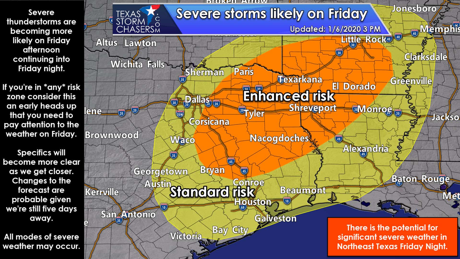
The severe weather outlook for Friday and Friday night. Please note this graphic was updated at 3 PM on January 6.
We now have a level three risk of severe weather for a potential event five days out. Having such high probabilities this early does not always result in a significant severe weather episode, but sometimes it does. Do not for a second think these risk lines are etched into stone. I want you to pay attention if you’re nearby any of these risk zones. Don’t get worked up over where the yellow or the orange lines are drawn. If you’re in or near either risk zone, this is your early warning that you better pay attention to weather come Friday.
A level three risk of severe weather encompasses all of Northeast Texas, eastern North Texas, the northeastern Brazos Valley, and East Texas Friday afternoon through early Saturday morning. This risk could include the threat of damaging straight-line winds, large hail, and tornadoes. The exact timing of the threat, along with the magnitude of each specific hazard, will be determined once we get closer to Friday. Those in this enhanced severe weather risk have a thirty percent (30%) chance of severe weather occurring within 25 miles of their location Friday afternoon and Friday night – a nearly one in three chance.
A level two risk of severe weather includes the eastern half of North Texas, portions of Central Texas, the northeastern Coastal Plains, the southwestern half of the Brazos Valley, Southeast Texas, and the Upper Texas Coast. The western delineation of the risk will depend on the timing of Friday’s storm system. The risk may get pulled a bit farther west or pushed a bit farther east in future outlooks. Damaging straight-line winds, large hail, and a tornado threat may develop. The exact timing of the threat, along with the magnitude of each specific hazard, will be determined once we get closer to Friday. Those in this level two severe weather risk have a fifteen percent (15%) chance of severe weather occurring within 25 miles of their location Friday afternoon and Friday night – a nearly one in five chance.
Again – please do not nitpick and get drawn (see what I did there?) into the exact line placements. I promise you they’re going to change several times between now and Friday afternoon. If you are near Interstate 35 from the Red River south to San Antonio and points east – you need to keep an eye on the weather on Friday and check back for forecast updates throughout the week as severe thunderstorms may occur.
I don’t think I need to remind folks that dangerous thunderstorms can occur at any time of the year. Mother nature does not care if it is January, March, May, October, or December.
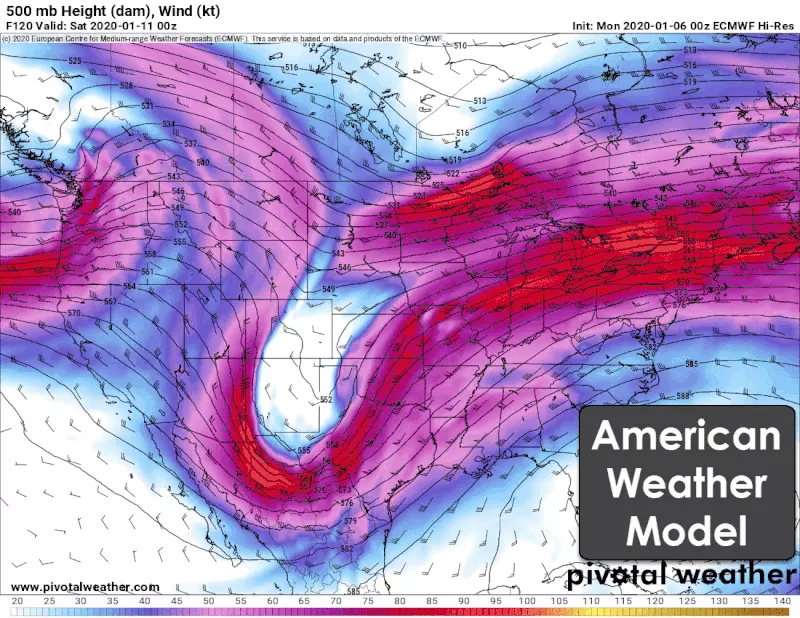
The above animation depicts two of our primary weather models. Winds around 18,500 feet above sea level are shown at 6 PM on Friday. I elected to include the animation to demonstrate that there remains disagreement on the timing of the upper-level storm system. The American weather model (GFS) is faster, while the European model is a bit slower. Their differences would result in a six to ten-hour difference in the forecast. That’s not too unusual for being five days out. Regardless of the model of choice, both models are showing a severe weather threat.
All the recent warm weather and the lack of an arctic cold front will allow for a large moisture-rich, unstable airmass to arrive ahead of the storm system on Friday. With that unstable airmass in place, the arriving storm system will bring other ingredients needed for severe weather – such as lift and strong wind shear. The combination of those features (plus more I’m just not nerdy enough to discuss this morning) will likely lead to the first severe weather event of 2020 for the United States this weekend. We’ll be on the starting line here in Texas, as usual, for the winter months. Unlike the last event a few days before Christmas, it looks like we’ll be getting in on the severe weather risk this time around. Still – things can and will change. We’ll monitor the latest data and bring you more information over the coming days. This is an excellent time to review your severe weather safety plans if you live in the eastern third of Texas. Even if it isn’t needed on Friday – it is always wise to review those safety plans while the weather is beautiful.
You can always get your latest local forecast directly from the National Weather Service. For more information on severe weather outlooks and how they’re made, along with details on the risk scale itself, visit our severe weather center.


0 Comments