
Tornadoes weren’t on the ordering menu today but Imelda didn’t seem to care. That’s a recurring theme with this storm and one characteristic I personally would have preferred it gone without. With the area of low-pressure northeast of Houston that would typically place Southeast Texas and the Upper Texas Coast in an unfavorable position for tornadic activity. However, strong thunderstorms were moving east/southeast late this afternoon through the Houston metro. Some sort of boundary moved in off the Gulf, possibly from prior storms, and resulted in a brief uptick in low-level wind shear. What was an unfavorable environment for tornadoes briefly came more favorable.
Based off video at least two brief tornadoes occurred this evening just east and southeast of Houston proper. The National Weather Service in Houston will likely conduct damage surveys tomorrow (if the weather allows) to determine the number of tornadoes and their damage rating. We’re going to focus on the overnight forecast as we quickly transition back to flash flooding concerns across the Upper Texas Coast, Southeast Texas, Far Southeast Texas, and portions of East Texas by Thursday morning.
An additional five to ten inches of rain is expected to fall tonight from just east of the Houston metro into Far Southeast Texas and portions of southern East Texas. This does include Beaumont, Port Arthur, north to Woodville and Jasper. Not everyone will receive a boatload of rain. Isolated rain totals over 15 inches are possible by late Thursday morning. I’ll discuss our reasoning behind that assessment below. Depending on how rain bands behave overnight we may be able to keep Houston just west of any potential heavy rain mischief, but that’s not a guarantee as rain-bands may redevelop at times. Southern and eastern portions of the Houston metro have received upwards of ten inches of rain over the last day and a half – so any more rain would cause problems. Flooding problems are ongoing at the time of this writing across southern Harris, Chambers, and Galveston counties.
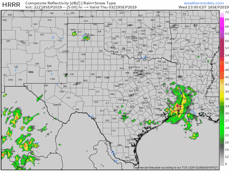
22Z HRRR: Simulated weather model radar from 10 PM this evening to 10 AM Thursday.
Our primary concern will be on where a band of very heavy rain sets up and essentially sits overnight. The HRRR (High-Resolution Rapid Refresh) model shows that occurring over far Southeast Texas and portions of southern East Texas. If this model solution were to verify, which it does seem to match current data, would result in a significant and potentially life-threatening flash flood event in/near Beaumont, Orange, Kountze, and Kirbyville. This is the kind of scenario that would have hourly rain-rates of two to four inches an hour for several hours.
Localized rain totals overnight may exceed fifteen inches. Nothing good happens when a location receives fifteen inches of rain in a twelve-hour period. Severe impacts would be likely including major flooding, numerous roadways underwater and/or washed out, along with flooding in locations that don’t flood on a regular basis.
The saving grace for Houston *may* be the low’s position later tonight. That may keep the heaviest rains east of Houston proper most of the night. If, and that’s a big if, we have rain bands develop farther west tonight or in the morning, we could see flash flooding rapidly become an issue in more of Southeast Texas, including Houston. Flash flooding would develop more quickly in locations that have already received several inches of rainfall over the past few days.
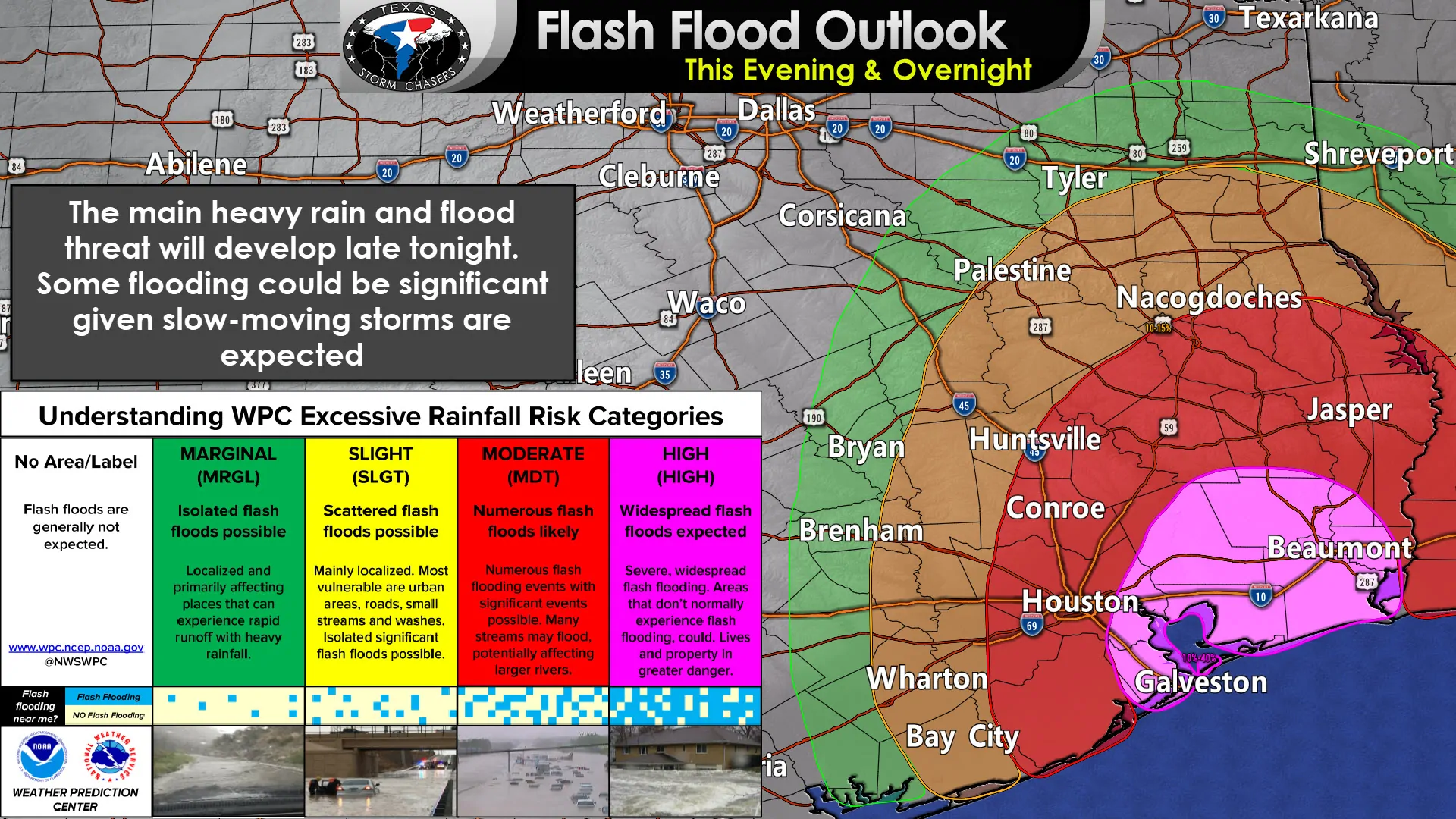
A high risk of flash flooding has been issued by the Weather Prediction Center tonight for far Southeast Texas and the Upper Texas Coast. We note their definition of a high risk includes “Widespread flash floods expected. Severe, widespread flash flooding. Areas that don’t normally experience flash flooding, could. Lives and property in greater danger. That would certainly apply to some locations late tonight if we have very heavy rains sitting over any urban population centers.
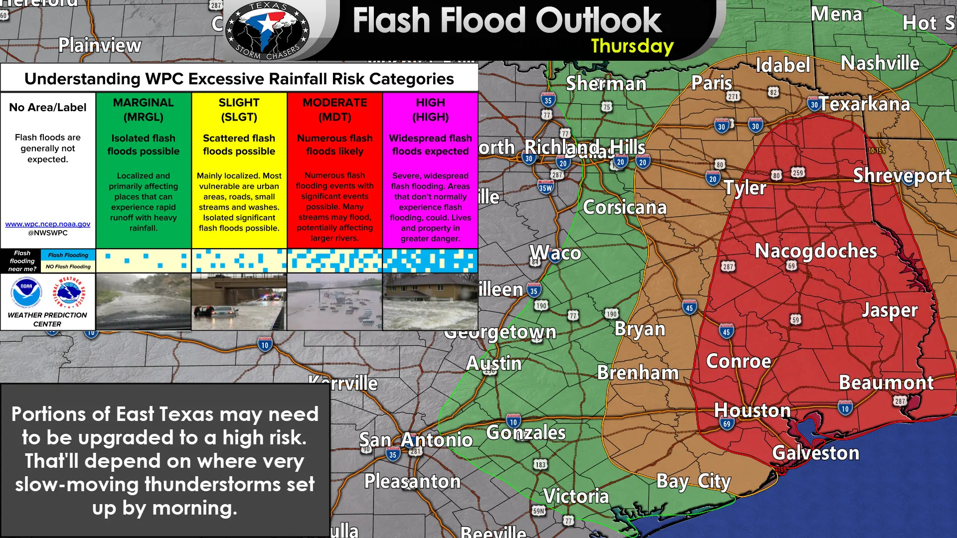
Heavy rains will continue into Thursday across Far Southeast Texas, East Texas, and Southeast Texas. Like today we’ll see convection blossom farther away from the low-pressure area during the daytime hours. Some of those storms will likely produce heavy rain, quite a bit of lightning, and perhaps some gusty winds. This will also allow heavier rains to start spreading farther north in East Texas and toward Northeast Texas on Thursday and Thursday Night. We note a large moderate risk of flash flooding is in place for tomorrow across Southeast Texas, East Texas, and even parts of Northeast Texas. We’ll deal with tomorrow’s issues once we get through tonight.
I’ll be here all night to provide updates here on our blog and on our social media platforms. You can keep up with the latest flash flood warnings and where the heaviest rains are falling with our free HD interactive weather radar here on our website and in our free mobile app.


0 Comments