
Good morning and welcome to June 19th. It isn’t every year that we have to deal with an organized severe weather threat this late in the ‘season’, but we’ve dealt with a tornado outbreak the day after Christmas – so really these severe weather threats can happen any time of year. Regardless, we do have the potential for severe weather this afternoon in North Texas and Northeast Texas. The squall line that moved through the aforementioned regions this morning likely left a few outflow boundaries. Those boundaries will have to be watched later today as they can be where thunderstorms first develop and they can also locally enhanced low-level wind shear. That enhanced low-level wind shear could result in a comparatively higher threat for a tornado *IF* an organized thunderstorm were to interact with it. We’ll chat about it all in greater detail below. Let’s take a glance at the latest severe weather outlook for today.
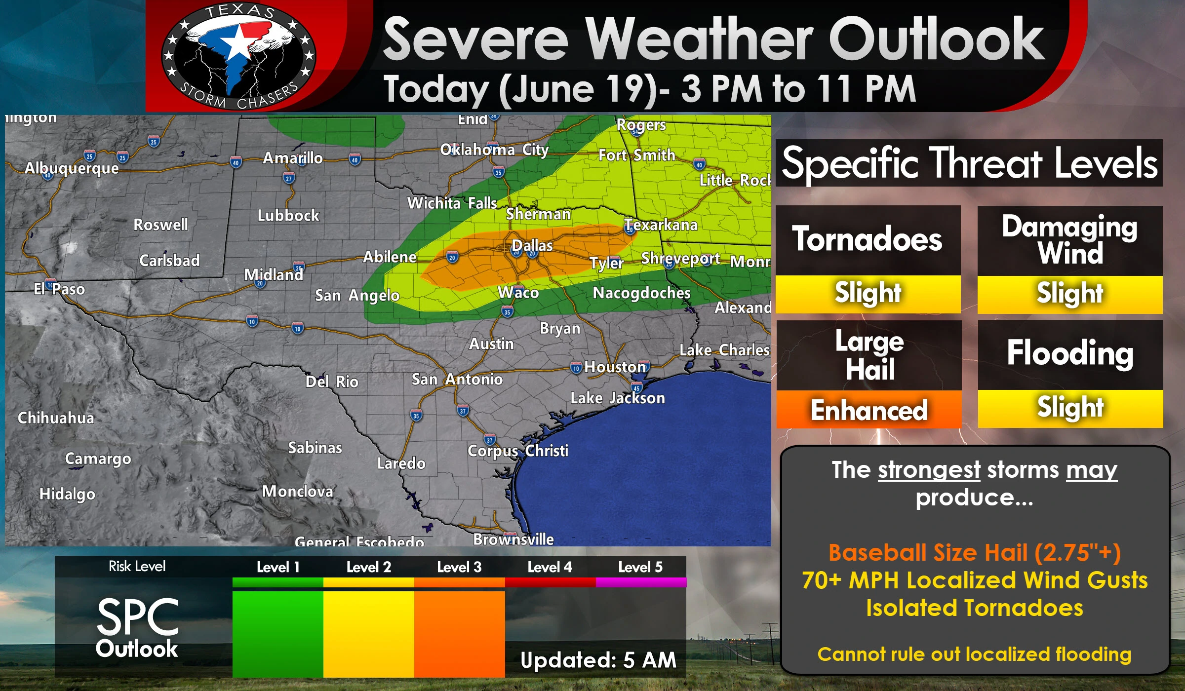
The Storm Prediction Center has upgraded portions of North Texas to a level 3 risk of severe weather this afternoon That corridor isn’t overly large, but does include all of the D/FW Metroplex extending back west toward Stephenville and east/northeast to Mount Pleasant. That upgrade was a result of increased probabilities of large hail this afternoon (30% within 25 miles of any given point, such as your home). A level 2 risk of severe weather surrounds that enhancement and runs from new Brownville and Bowie east through the Arklatex. A level 1 risk runs a bit farther to the northwest and to the south of the higher risk levels. The higher the risk the higher chance of severe weather in your area this afternoon and evening.
Let me be abundantly clear that I encourage folks not to fixate on the exact placements of each risk zone. Mother Nature doesn’t care where we draw lines and these late spring setups can often shift depending on where we have certain features set up. Weather models do not handle those features very well, so it’s more of a ‘watch and wait’ scenario. Those aforementioned outflow boundaries, wherever they set up, could be where we have the highest relative threat of severe storms develop later this afternoon. If you’re in or near any risk zone that means this is your heads up to keep an eye on the weather radar later today. You’ll know when there’s a storm because it’ll probably be 60,000 feet tall given the extremely unstable airmass we’re anticipating this afternoon. You can also use our free HD interactive weather radar here on our website and in our free mobile app (there’s a banner at the top of this page that’ll take you to our app).
What I’m telling you now could easily end up being different by the early afternoon hours, but here’s how things are looking at the time of this writing. Those storms moving through this morning should be exiting (or dissipating) by the mid-morning hours. Cloud cover should be clearing and mostly sunny skies should be underway across North Texas by the late morning hours. A very humid airmass will coincide with temperatures soaring into the 90s. It’s going to be a hot and steamy day. All that moisture and heat will result in the atmosphere becoming extremely unstable across North Texas. It’ll be a ‘powder-keg’ just waiting for a thunderstorm to take advantage of it.
We do have a storm system moving overhead this afternoon which will translate into higher winds aloft. Those winds aloft will help thunderstorms organize once they develop. Instead of the typical summer-time ‘popcorn’ storms that fire up and rain themselves out within an hour, we’ll be dealing with supercelluar storm modes, at least initially. The first storms of the day may end up firing near a boundary in the Arklatex southwest into Northeast Texas after 3-4PM. Those storms will generally move east (perhaps northeast at first) with a threat of large hail.

Simulated weather model radar from the HRRR this afternoon and evening. Remember, this is the kind of day where localized features may not be detected by weather models very well. Keep an eye to the sky and be ready for some forecast surprises.
When storms do fire farther west into North Texas they’ll likely do so in an explosive fashion. When they ‘break the cap’ they’re going to explode and probably become severe quite quickly. Assuming we are dealing with supercelluar storm modes versus a line or cluster those strongest supercells could easily produce very large hail up to the size of baseballs. If a longer-track, intense supercell develops we could see a threat of giant hail (softball size) somewhere in North Texas during the late afternoon or early evening hours.
Localized damaging wind gusts and a few tornadoes are also threats. The tornado threat will be tempered by weak low-level wind shear, but extreme instability value sand the presence of those boundaries (which can locally enhance low-level wind shear) do suggest some tornado threat will exist in North Texas and Northeast Texas this afternoon and early this evening.
Storms will eventually grow upscale into a squall line or cluster that’ll move east/northeast into Northeast and East Texas. That’ll be when the threat transitions over to damaging winds with some large hail. Storms may not be able to develop south into Central Texas or the Brazos Valley due to a stronger cap, but we will keep a close eye out just in case they do develop a bit farther south than what the current risk graphics indicate. Storms should be moving east/northeast out of Texas by midnight.
Localized flash flooding will be possible thanks to saturated soils and the potential for a quick couple inches of rain from the most intense storms. That flooding threat will be higher in urban areas with poor drainage and run-off.


0 Comments