
Crews from multiple National Weather Service offices have been busy conducting damage surveys from the May 29, 2019 outbreak. Those crews have confirmed at least twelve tornadoes occurred along with significant straight-line wind swaths. Some of those straight-line winds produced winds of 100 MPH – comparable to the tornadoes confirmed. I highlight that because it goes to show that straight-line winds can be just as dangerous as many of the tornadoes we deal with in Texas. That’s also a good tidbit of information to remember as we enter the summer season of overnight squall lines next week.
The most severe tornado damage found by survey crews were near the Cedar Creek Resovar near Kemp, the community of Whitton southwest of Canton, and a long-lived/large tornado east of Winnsboro that tracked northeast into Franklin County. All three of those tornadoes were rated EF2s – or ‘strong’ on the Enhanced-Fujita Scale. Tornadoes are rated based on the damage they produce. If a tornado does not impact structures or damage-indicators it is rated an EF0 or EF-U (Unknown).
The survey results below may be a bit tedious to read over. I’ve attempted to highlight each ‘tornado’ in bold to make it easier to find a specific track. These results are not final and some adjustments and/or additions may be made as crews continue to work.
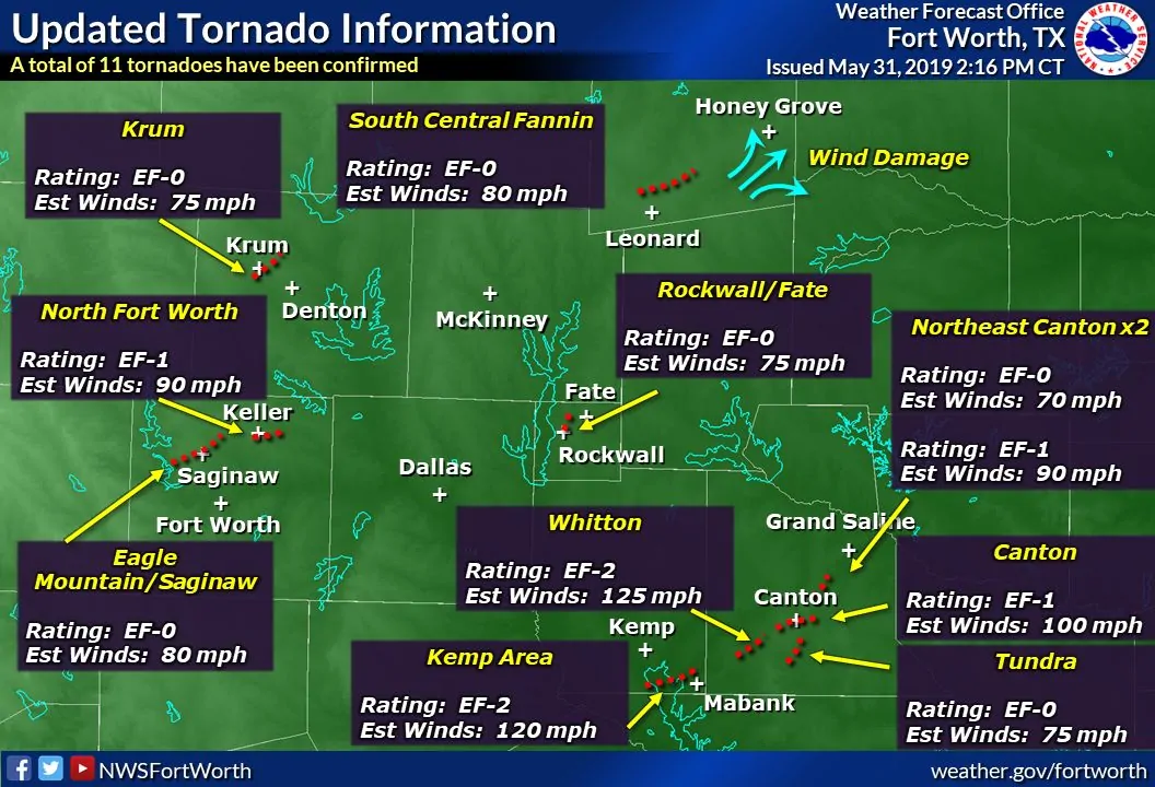
Click image for full-screen version
Eagle Mountain/Saginaw Area (Tarrant County)
Rating: EF0
Estimated Peak Wind: 80 mph
Path Length /statute/: 3.87 miles
Path Width /maximum/: 200 yards
Fatalities: 0
Injuries: 0
Start Date: 05/29/2019
Start Time: 01:19 PM CDT
Start Location: 2 SE Eagle Mountain / Tarrant County / TX
Start Lat/Lon: 32.8667 / -97.4199
End Date: 05/29/2019
End Time: 01:26 PM CDT
End Location: 1 NNE Saginaw / Tarrant County / TX
End Lat/Lon: 32.8864 / -97.3584
Survey Summary:
This tornado initially formed near the Villages of Eagle Mountain
subdivision, damaging one home where some of the bricks on the
front part of the house fell off. The tornado continued on a track
to the east-northeast between W Bailey Boswell Rd and WJ Boaz Rd.
In this neighborhood, a couple of trees were snapped, consistent
with 80 mph EF-0 winds, but most of the damage found was broken
tree branches. The tornado then moved over N Saginaw Blvd (US
287/81) damaging several business signs and bending power poles.
It continued to move east-northeast, dissipating between E Bailey
Boswell Road and Darlington Trail, where no more damage was
found.
Krum (Denton County)
Rating: EF0
Estimated Peak Wind: 75 mph
Path Length /statute/: 3.72 miles
Path Width /maximum/: 250 yards
Fatalities: 0
Injuries: 0
Start Date: 05/29/2019
Start Time: 01:22 PM CDT
Start Location: 1 SW Krum / Denton County / TX
Start Lat/Lon: 33.2571 / -97.2409
End Date: 05/29/2019
End Time: 01:31 PM CDT
End Location: 3 ENE Krum / Denton County / TX
End Lat/Lon: 33.2864 / -97.1892
Survey Summary:
An EF-0 tornado formed just south of the center of Krum. The
tornado moved northeast through the eastern portion of the
community, producing tree damage and isolated power line damage.
The tornado dissipated just northeast of the Krum High School.
North Fort Worth (Tarrant County)
Rating: EF1
Estimated Peak Wind: 90 mph
Path Length /statute/: 0.45 miles
Path Width /maximum/: 300 yards
Fatalities: 0
Injuries: 0
Start Date: 05/29/2019
Start Time: 01:31 PM CDT
Start Location: 4 SSE Haslet / Tarrant County / TX
Start Lat/Lon: 32.9115 / -97.3065
End Date: 05/29/2019
End Time: 01:34 PM CDT
End Location: 4 SE Haslet / Tarrant County / TX
End Lat/Lon: 32.9129 / -97.2989
Survey Summary:
A brief EF-1 tornado occurred across parts of the Heritage
neighborhood in North Fort Worth. Most of the damage was found in
an approximate 8 block area south of Heritage Trace Parkway. There
was tree damage, roof covering loss and broken windows. Two homes
in on Oliver Drive sustained the most damage but thankfully the
damage was minor. The tornado started near Burts Dr (just east of
Riverside Rd) and dissipated three minutes later near Kimbell Dr.
Rockwall/Fate (Rockwall County)
Rating: EF0
Estimated Peak Wind: 75 mph
Path Length /statute/: 3.06 miles
Path Width /maximum/: 25.0 yards
Fatalities: 0
Injuries: 0
Start Date: 05/29/2019
Start Time: 02:58 PM CDT
Start Location: 1 E Rockwall / Rockwall County / TX
Start Lat/Lon: 32.9247 / -96.44
End Date: 05/29/2019
End Time: 03:03 PM CDT
End Location: 3 NW Fate / Rockwall County / TX
End Lat/Lon: 32.9681 / -96.4285
Survey Summary:
Video from near the Leon Tuttle Athletic Complex showed the start
of the tornado over the ball fields. Some minor damage occurred as
bleachers were lifted and pushed into a backstop. A scoreboard
sustained some minor damage and metal sheet roofing was lifted
into the air. The tornado moved north and crossed the airfield at
Rockwall Municipal Airport, but no damage was reported there.
Picture evidence from numerous citizens in Rockwall and Fate shows
the condensation funnel of the tornado became more pronounced as
it moved north of W Holiday Road between N John King Blvd and N
Stodghill Rd ,through some low density residential areas and
ranchland. No additional damage was found along this track, and
the tornado is believed to have terminated before reaching FM 552
based on radar and picture evidence.
Tundra Area (Van Zandt County)
Rating: EF0
Estimated Peak Wind: 75 mph
Path Length /statute/: 2.96 miles
Path Width /maximum/: 100.0 yards
Fatalities: 0
Injuries: 0
Start Date: 05/29/2019
Start Time: 03:07 PM CDT
Start Location: 4 SSW Canton / Van Zandt County / TX
Start Lat/Lon: 32.4897 / -95.8883
End Date: 05/31/2019
End Time: 03:14 PM CDT
End Location: 2 SSE Canton / Van Zandt County / TX
End Lat/Lon: 32.52 / -95.8532
Survey Summary:
A tornado developed near Van Zandt CR 2213, then tracked northeast
across HWY 19 south of Canton. Shingle damage occurred to a home,
as well as tree branches were broken. The tornado then began to
dissipate east of Hwy 19, damaging another home on Van Zandt CR
4201 near Mill Creek.
Northeast of Canton #1 (Van Zandt County)
Rating: EF0
Estimated Peak Wind: 70 mph
Path Length /statute/: 0.24 miles
Path Width /maximum/: 50 yards
Fatalities: 0
Injuries: 0
Start Date: 05/29/2019
Start Time: 03:17 PM CDT
Start Location: 3 NE Canton / Van Zandt County / TX
Start Lat/Lon: 32.589 / -95.83
End Date: 05/31/2019
End Time: 03:18 PM CDT
End Location: 4 NE Canton / Van Zandt County / TX
End Lat/Lon: 32.5914 / -95.8271
Survey Summary:
A spotter reported debris being lofted by a tornado north of FM
17 and Interstate 20. This is the same location where a tornado
tracked later in the day and where signs of damage remain from a
tornado that crossed that area in 2017, so determining a path was
near impossible.
Kemp Area (Kaufman County)
Rating: EF2
Estimated Peak Wind: 120 mph
Path Length /statute/: 4.01 miles
Path Width /maximum/: 215.0 yards
Fatalities: 0
Injuries: 0
Start Date: 05/29/2019
Start Time: 04:24 PM CDT
Start Location: 3 N Seven Points / Kaufman County / TX
Start Lat/Lon: 32.3683 / -96.2125
End Date: 05/29/2019
End Time: 04:30 PM CDT
End Location: 3 WNW Mabank / Kaufman County / TX
End Lat/Lon: 32.3917 / -96.1505
Survey Summary:
A tornado began in southern Kaufman County on the northwest side
of Cedar Creek Reservoir, near FM 4042 and Valentine Rd. Notable
tree damage was observed at the start of the track. The tornado
crossed the reservoir and struck the peninsula where Cedar Creek
Golf Course is located. Significant tree damage occurred along the
track in the form of uprooted and snapped large hardwood trees.
Some trees were snapped near the base, but most were snapped about
half way up the trunk. The tornado appeared to strengthen to EF-2
winds as it crossed the golf course. On the east side of the
peninsula, the tornado significantly damaged a house, lifting the
roof off over an attached indoor swimming pool and part of the
roof over the main house. The tornado then crossed the reservoir
again, did minor tree damage across Hwy 175 and dissipated just
past the highway.
Whitton Area (Van Zandt County)
Rating: EF2
Estimated Peak Wind: 125 mph
Path Length /statute/: 7.24 miles
Path Width /maximum/: 700 yards
Fatalities: 0
Injuries: 0
Start Date: 05/29/2019
Start Time: 04:51 PM CDT
Start Location: 9 WSW Canton / Van Zandt County / TX
Start Lat/Lon: 32.4831 / -96.0012
End Date: 05/29/2019
End Time: 05:00 PM CDT
End Location: 2 W Canton / Van Zandt County / TX
End Lat/Lon: 32.5475 / -95.9059
Survey Summary:
A tornado developed near the community of Whitton, then moved
northeast, damaging several homes in its path. The most extensive
damage was found on Van Zandt CR 2502 and Van Zandt CR 2501,
where the EF-2 determination was made. Homes experienced significant
roof loss, and a manufactured home was destroyed and tossed well away
from its foundation. The tornado then continued moving northeast,
easily traceable from continuous tree damage along its path. This
tornado then occluded and dissipated as it approached the City of
Canton.
Canton (Van Zandt County)
Rating: EF1
Estimated Peak Wind: 100 mph
Path Length /statute/: 2.33 miles
Path Width /maximum/: 140.0 yards
Fatalities: 0
Injuries: 0
Start Date: 05/29/2019
Start Time: 05:08 PM CDT
Start Location: 1 W Canton / Van Zandt County / TX
Start Lat/Lon: 32.5447 / -95.8844
End Date: 05/29/2019
End Time: 05:15 PM CDT
End Location: 1 NE Canton / Van Zandt County / TX
End Lat/Lon: 32.5627 / -95.8508
Survey Summary:
A tornado developed near Canton High School then moved to the
northeast toward downtown Canton. Abundant tree damage occurred in
southwest Canton, then the tornado strengthened as it approached
downtown Canton. Structural damage to several businesses was found
as well as tree trunks snapped closer to Interstate 20. This
tornado lifted as it approached Interstate 20.
Northeast of Canton #2 (Van Zandt County)
Rating: EF1
Estimated Peak Wind: 90 mph
Path Length /statute/: 3.81 miles
Path Width /maximum/: 250.0 yards
Fatalities: 0
Injuries: 0
Start Date: 05/29/2019
Start Time: 05:18 PM CDT
Start Location: 3 NE Canton / Van Zandt County / TX
Start Lat/Lon: 32.5804 / -95.8161
End Date: 05/29/2019
End Time: 05:23 PM CDT
End Location: 4 SSE Fruitvale / Van Zandt County / TX
End Lat/Lon: 32.623 / -95.7792
Survey Summary:
A tornado developed northeast of Canton, then tracked to the
north-northeast affecting mostly vegetation. Several trees were
snapped and uprooted along the path. As the tornado began to
occlude, minor damage was found to a property along FM 17 and Van
Zandt CR 1222.
Fannin County
Rating: EF0
Estimated Peak Wind: 80 mph
Path Length /statute/: 10.84 miles
Path Width /maximum/: 300 yards
Fatalities: 0
Injuries: 0
Start Date: 05/29/2019
Start Time: 05:31 PM CDT
Start Location: 3 NW Leonard / Fannin County / TX
Start Lat/Lon: 33.4171 / -96.2788
End Date: 05/29/2019
End Time: 05:47 PM CDT
End Location: 4 NE Bailey / Fannin County / TX
End Lat/Lon: 33.4698 / -96.102
Survey Summary:
A severe thunderstorm produced a long, narrow swath of straight
line wind and tornado damage across southern Fannin County. This
path of damage extended approximately 25 miles, from southeast of
Trenton to south of Honey Grove. Most of the straight line wind
damage took the form of snapped and uprooted trees, associated
with wind speeds of 70-85 mph. Within the overall wind swath, the
survey team found damage consistent with at least one EF-0
tornado. This tornado formed approximately 3 miles southeast of
Trenton, and moved east-northeastward 11 miles before ending in
the Gober community. The tornado snapped and uprooted numerous
trees along the path, and produced minor structural damage to
several homes and outbuildings. Peak wind speeds associated with
the tornado were estimated to be 85 mph. Additional significant
tree, residential and outbuilding damage occurred 1 to 2 miles
northwest through northeast of the Bug Tussle Community in eastern
Fannin County. This damage was likely associated with very strong
downburst winds on the order of 85 to 95 mph. The most
significant structural damage was observed along Highway 34,
approximately 1.6 miles north of Bug Tussle, where a site-built
frame residence had much of its roof blown off. Maximum straight
line winds at this location were estimated to be 95-100 mph.
Northeast Wood County, TX to Southeast Franklin County, TX
Rating: EF-2
Estimated Peak Wind: 112 mph
Path Length /statute/: 9.09 miles
Path Width /maximum/: 850 yards
Fatalities: 0
Injuries: 0
Start Date: 05/29/2019
Start Time: 4:50 PM CDT
Start Location: 3 SE Winnsboro / Wood County / TX
Start Lat/Lon: 32.9229 / -95.2473
End Date: 05/29/2019
End Time: 5:12 PM CDT
End Location: 7 W Rocky Mound / Franklin County / TX
End Lat/Lon: 33.022 / -95.1532
Summary: The tornado first touched down along County Road 4510,
about 2.5 miles southeast of Winnsboro, TX, where it snapped
branches on a tree and uprooted a large tree. The tornado
continued to move northeast near the intersection of County Road
4420 and County Road 4430 snapping and uprooting numerous trees,
along with damaging a large poultry farm and completely lifting
the roof off a single wide manufactured home. The tornado then
continued a northeast path destroying an outbuilding on County
Road 4440 then crossing State Highway 11 and across County Road
4360 completely destroying a large poultry farm. The tornado
continued to move northeast into Franklin County near the Scroggins
area and northeast along the west side of Lake Bob Sandlin before
lifting.
A special thanks goes out to the Wood County Fire Marshal`s Office
and Office of Emergency Management, Franklin County Emergency
Management, and Texas Department of Public Safety and Emergency
Management for their assistance in completing the damage survey.


0 Comments