
A level two risk of severe weather, the standard risk level, is in effect this afternoon for the eastern third of the Texas Panhandle. A somewhat diffuse dryline will set up east of Interstate 27/Highway 287 by the early afternoon hours. The remainder of the dryline farther south from West Texas and the Big Country through the Edwards Plateau should remain capped and thunderstorm free today.
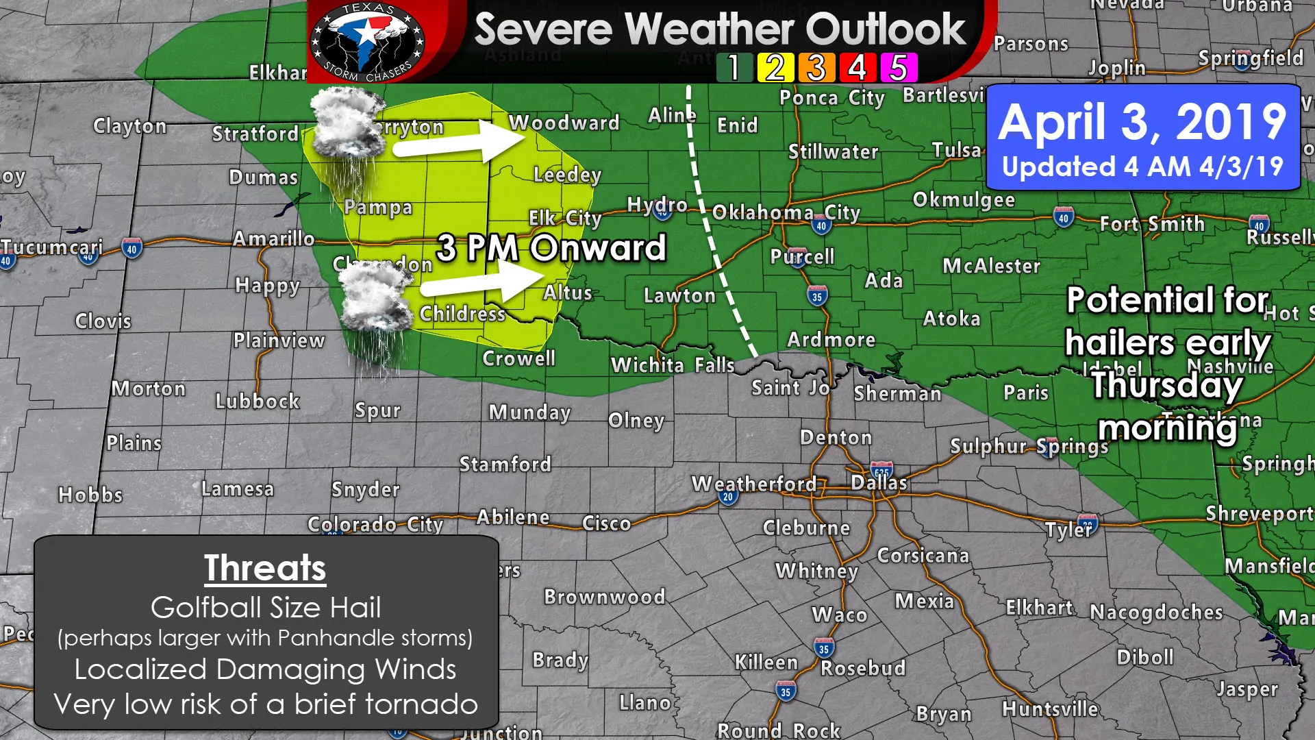
Moisture return today will be rushed and surface dewpoints will only make it into the upper 40s by 3 PM east of the dryline up in the Panhandle. That’s not bone dry, but with surface temperatures warming into the 70s, that’s not exactly a ‘prime’ airmass for severe weather development. Nevertheless, an approaching upper-level storm system will help increase instability levels in the mid-levels of the atmosphere. Short-range high-resolution weather models are fairly consistent in breaking the cap between 3-5 PM with isolated to widely scattered thunderstorm development thereafter.
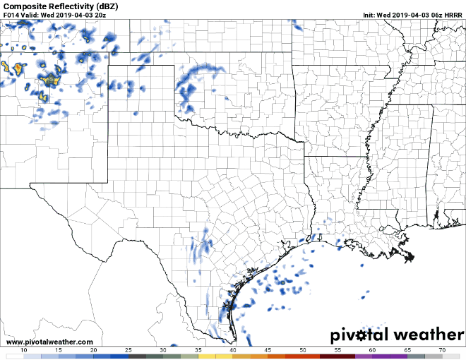
06Z HRRR Simulated Weather Radar from 3 PM this afternoon through 10 AM Thursday. This is only a simulation and won’t verify 100%, but it tends to do fairly well with overall timing and approx. locations.
The meager surface moisture will result in higher cloud bases. That’ll keep the tornado threat very low, but perhaps enhance the potential of localized damaging winds in the form of microbursts. Large hail is going to be the primary threat with storms today. Hailstones may exceed the size of golf balls in the stronger storms. I cannot entirely rule out a brief tornado if we end up with a deviant supercell (moving more east versus northeast) closer to sunset, but as I said, cloud bases should be too high to support much (if any) tornado threat. Seeing as I’ll be chasing out there this afternoon I wouldn’t mind a brief birdfart in an open field, but that isn’t on my expectation sheet today.
Storms that do get going in the Panhandle will move east/northeast into Oklahoma by the early evening hours. Storm coverage won’t be overly high thanks to a strong cap and that meager surface moisture. If we actually had dewpoints above 60 degrees in the Panhandle this afternoon we’d be looking at a major severe weather outbreak with several tornadic supercells. Alas, that won’t be the case (not saying it’s a bad thing).
Late tonight into Thursday morning
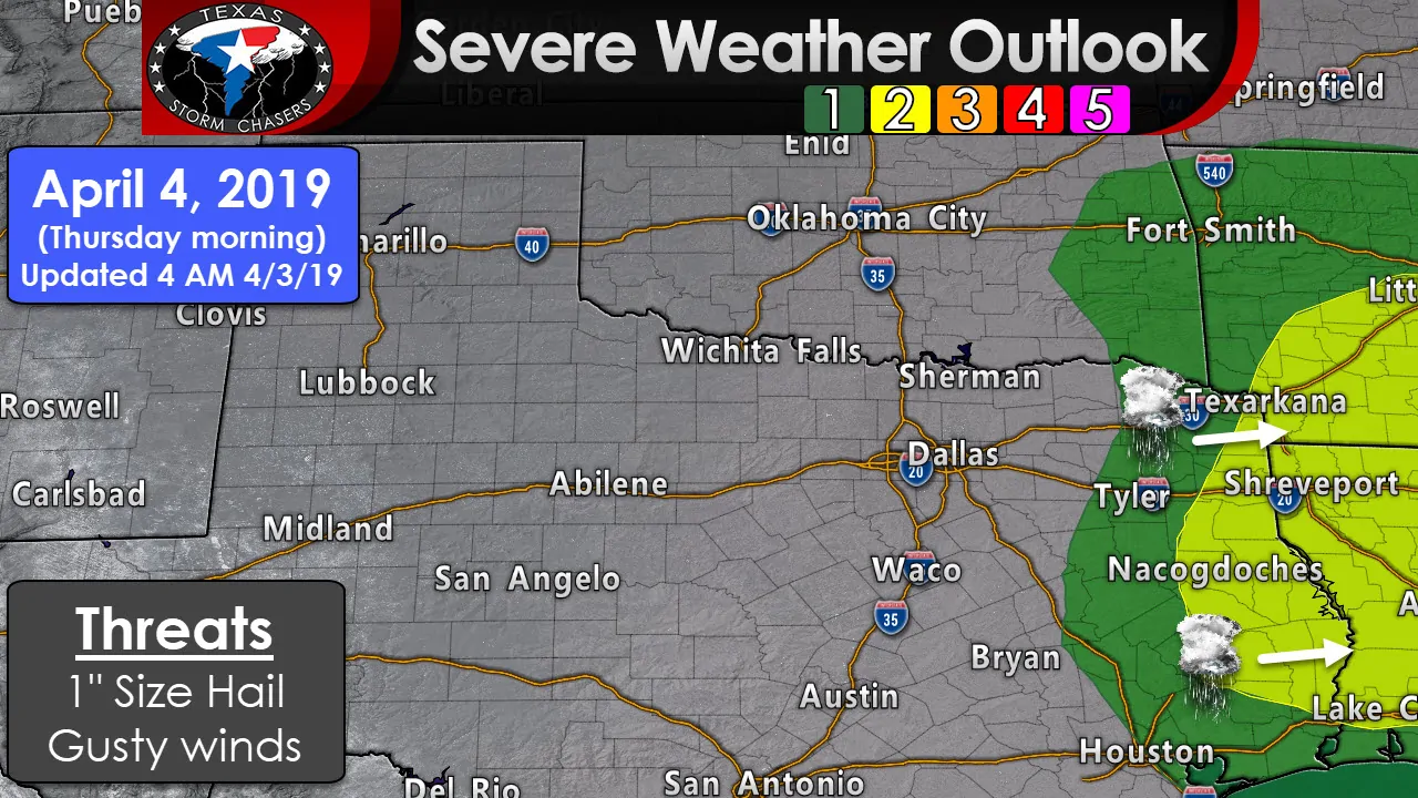
I can’t rule out a storm or two before sunrise Thursday morning in Northeast Texas, but the higher threat of storm development will be after 7 AM across Northeast Texas and East Texas. A level tow risk is in place for far East Texas tomorrow morning as storms fire up not long after sunrise. The strongest storms may produce hail and localized gusty winds. I’m not seeing much of a tornado risk in East Texas, but I can’t entirely rule out a tornado. That’ll be something we’ll have to watch with trends in future model data. It may be a situation similar to today where storms are high-based or elevated. They’d be capable of producing hail, but only a very low risk of a tornado. Storms will move east out of Texas by the early afternoon.
Friday night through Saturday night
A widespread precipitation event is expected to begin Friday night from Northwest Texas south through the Concho Valley. More scattered storms are possible farther west during the day Friday. This will translate into a big gullywasher for areas near Interstate 35 and points east on Saturday into Saturday Night. Generally speaking on a regional basis, we’re looking at 1 to 4 inches of rain in the aforementioned areas. Locally higher amounts are possible. That kind of rain will result in at least a localized potential for minor flooding. Some severe weather may also occur, but those details are unclear at this time. Nothing is screaming ‘major severe weather threat of doom’ at this point, but it is April. Any time you get a chance of storms in April you’re bound to have a risk for some gusty winds and hail. We’ll focus more on this weekend’s threat once we get past this evening and tomorrow.
Today’s chase plans
Yours truly needs to hit the sack since I’ll be heading out to the Texas Panhandle this afternoon with Paige (and perhaps Jason) on the hunt for some stormies. We’ll go live for our Facebook supporters group early this afternoon with a pre-chase video explaining our thoughts before storms get going. If all goes well we’ll have some cool photography to share later this evening. My personal goals for today are low. I just want some cool storm structure and the chance for evening lightning photography.


0 Comments