
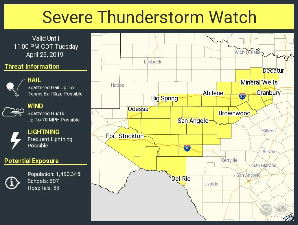
A severe thunderstorm watch has been issued for the Concho Valley, Big Country, and western North Texas. This watch is in effect through the afternoon and evening with an expiration time of 11 PM. Del Rio, Fort Stockton, Odessa, Big Spring, San Angelo, Abilene, Brownwood, Mineral Wells, Decatur, and Granbury are included in this watch. D/FW is not included in this watch, although the chance of storms will increase this evening as storms move in from the west. The strongest storms may be capable of producing hail up to the size of tennis-balls and localized damaging wind gusts up to 70 MPH. Heavy rainfall may cause isolated flash flooding.
 Severe Thunderstorm Watch Number 95
   NWS Storm Prediction Center Norman OK
   230 PM CDT Tue Apr 23 2019

   The NWS Storm Prediction Center has issued a

   * Severe Thunderstorm Watch for portions of
     Southwest into western north Texas

   * Effective this Tuesday afternoon and evening from 230 PM until
     1100 PM CDT.

   * Primary threats include...
     Scattered large hail and isolated very large hail events to 2.5
       inches in diameter possible
     Scattered damaging wind gusts to 70 mph possible

   SUMMARY...Thunderstorm development is expected along a slow-moving
   front the next few hours from southwest Texas into western north
   Texas, and over the high terrain west of Del Rio.  The storm
   environment along and south of the watch will favor splitting
   supercells capable of producing isolated very large hail and
   damaging gusts.  Storm clusters should persist into the early
   overnight hours along the front, with a gradual transition to
   locally heavy rainfall as the main concern.
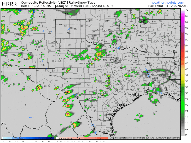
18Z HRRR simulated weather radar from 4 PM this afternoon until 7 AM Wednesday. This is only a model simulation, so it probably won’t be exactly spot-on. Click on the image for a full-screen version.
Storms will increase in coverage through the afternoon and evening hours near a stationary cool front. That front will act as a source of lift and tend to have the highest coverage of rain through the overnight hours. That setup could result in ‘training’ storms tonight. Concern over heavy rainfall and localized flash flooding will increase overnight and into Wednesday. We’ll keep an eye on rainfall data.


0 Comments