
A few strong to marginally severe storms may be ongoing this morning across portions of Texoma, Northeast Texas, and East Texas. Those storms should move east into Lousiana by this afternoon. Isolated redevelopment across far East Texas and Southeast Texas may occur this afternoon. If that redevelopment does occur those storms could become strong with a threat of hail and localized gusty winds. Otherwise, we’re expecting a lull this evening and overnight, but the break will be short-lived.
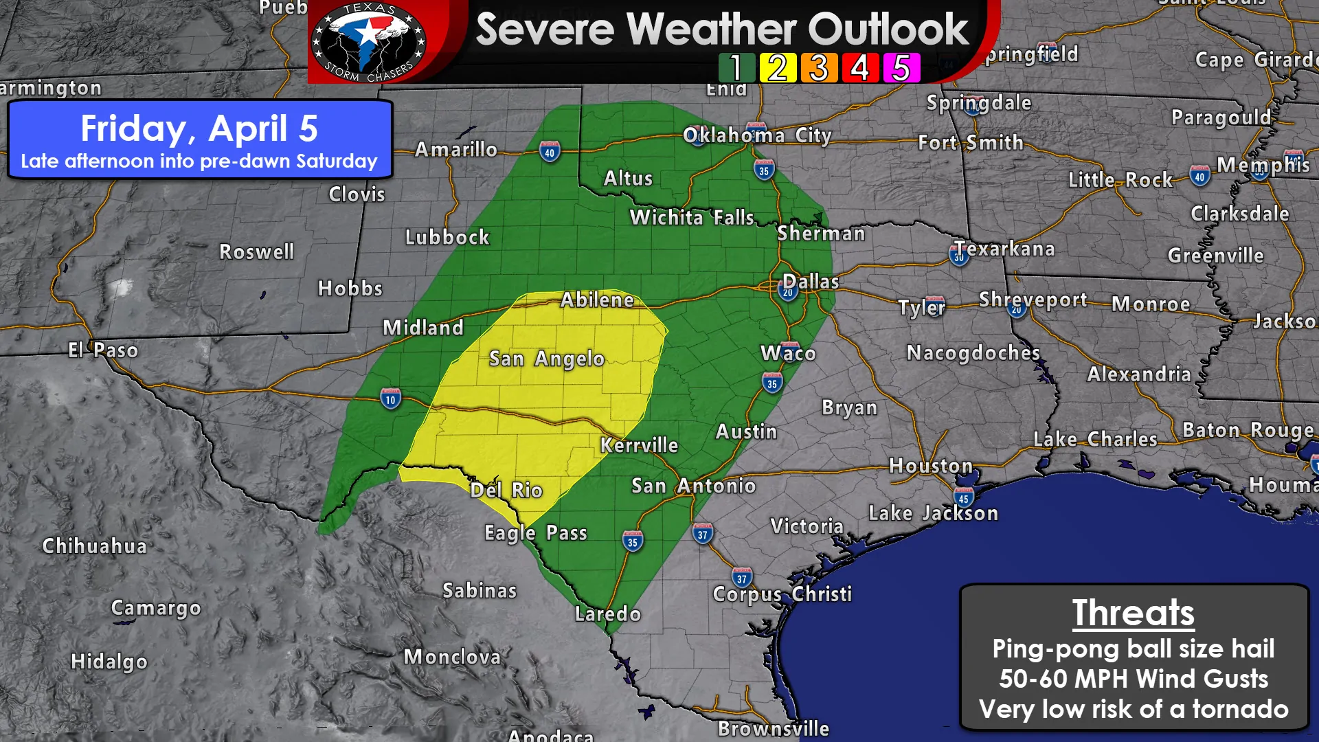
Scattered thunderstorms may begin developing between 3 and 5 PM tomorrow east of a dryline located across the eastern Permian Basin, West-Central Texas, into western portions of the Big Country and Concho Valley. Some of those storms will probably be severe with a risk of large hail. How quickly moisture can return, specifically dewpoint values will play a role in the overall intensity of the afternoon activity. If dewpoints are able to climb into the upper 50s to 60s we’d have a higher threat of more substantial severe weather (big hail, a non-zero tornado risk). Those storms will make their way toward Northwest Texas by Thursday evening while slowly weakening.
Friday Night into Saturday morning
Additional thunderstorms are expected to develop Friday evening across the Permian Basin as stronger upper-level lift arrives. This line of storms will probably become strong to severe with hail and damaging wind gusts possible. Surface dewpoint values in the Permian Basin aren’t expected to be all that impressive with dews in the 40s to the lower 50s. That’s enough to support elevated thunderstorms with hail and gusty winds but would tend to be too low to support much of a surface-based storm threat (thus keeping the tornado threat very low).
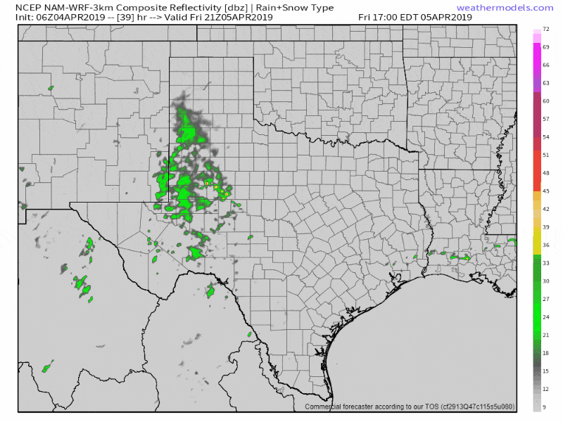
6Z 3KMNAM Simulated Weather Radar for Friday afternoon through Saturday morning. This is at the extended range for this higher-resolution model and thus is likely to be less accurate. However, it depicts the scenerio of an eastward moving squall line. Don’t get hung up on specifics beyond that. Also, this does not include Saturday afternoon/evening where more storms may fire up ASSUMING the atmosphere can destabilize behind morning storms.
Wind fields ahead of the line of storms will intensify Friday night as the storms move east. Those increasing winds will help to pump higher moisture values into the Concho Valley, Big Country, and Hill Country by early Saturday morning. More moisture means more instability for storms to work with (even if its the middle of the night). In addition to increasing moisture values, those strong winds will help the squall line increase and maintain organization as it moves east. Like the thunderstorm event about one month ago, we may be dealing with a case of storms producing damaging straight-line gusts and brief tornadoes as they move east late Friday night into the morning hours on Saturday. Hail is also probable with the stronger storms.
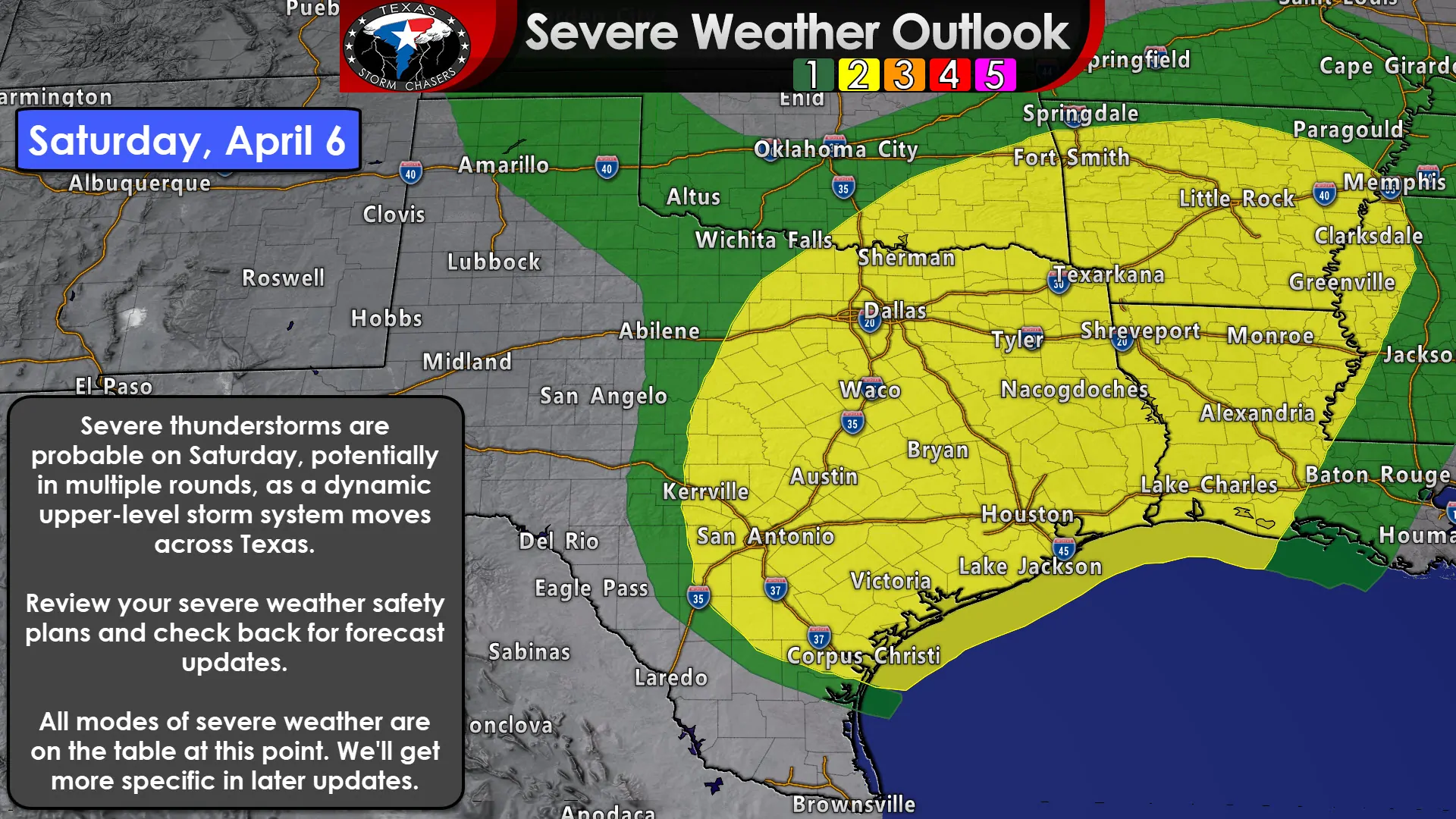
That squall line, or perhaps a broken line of thunderstorms, would likely move east into North Texas, Central Texas, and South-Central Texas around sunrise on Saturday – and could still contain severe storms. The dryline would still be located back from near Childress to San Angelo, so depending on how quickly storms clear out, we could see another round of strong to severe storms fire up Saturday afternoon east of that dryline. Those would move east Saturday evening with a severe weather threat. The environment across East Texas late Saturday morning into the afternoon would also be supportive of severe thunderstorms. Saturday’s severe weather outlook features a large ‘zone’ of severe weather potential. I expect that we’ll see that refined in future updates as we get closer in range.
That’s the forecast, but…
Tomorrow and especially Saturday is a low-confidence forecast. This is April and severe weather chances are just the typical spring regimen in the southern United States. We’ll probably be getting busy Friday night and on Saturday. I wouldn’t be surprised if we had to deal with multiple rounds of storms on Saturday as an upper-level storm system slowly moves across Texas. The scenario I described above will likely change as we get closer to Saturday and in range of more accurate and high-resolution weather model data. Be sure to check back for the latest forecast. Rain/storm chances will continue into Saturday night and Sunday, especially across the eastern third to the eastern half of Texas. Eventually, storm chances will end from west to east on Sunday.
The heat is on come next week
Above-average temperatures are likely by Tuesday and Wednesday of next week. That means we’ll be seeing a lot of the 80s and 90s across Texas by Wednesday. I wouldn’t be surprised if we saw a couple of triple-digit high temperatures sneak in somewhere. April is looking active in the severe weather department with another storm system around Friday-Saturday of next week – and that one already has indications of being a severe weather maker somewhere in the southern United States before another blast of below-average temperatures. Welcome to April folks. Our spring severe weather season is here. We’ll be watching and posting updates to keep y’all informed.


0 Comments